Situation Summary
Syria remains fractured across multiple competing power centres—Assad regime forces, Turkish-backed opposition groups, US-backed SDF, ISIS remnants, and Iranian-aligned militias—with no consolidated state monopoly on security or territory. The composite threat ranking of 94 and 71 tracked events reflect persistent armed conflict, occasional terrorist activity, and sporadic criminal violence rather than systemic state collapse, but the absence of credible central authority outside regime strongholds keeps risk acute for any international presence. The trajectory remains static to slowly degrading; no major shift toward stability or renewed full-scale conflict is evident in current signals, but the environment remains volatile and compartmentalised by geography and actor.
Key Developments
GeoBit's live web research and available event feeds for the past 24–48 hours do not yet provide time-stamped, cross-verified incident reporting at the granularity required for a credible SITREP. The event signal list references multiple incidents flagged on 9–11 June (small-arms combat, unconventional violence by military units, arrests, ministry statements, and rejections by regime and school bodies), but source-level detail, precise location, and independent corroboration are not yet available in the current search results to present as confirmed developments.
Recommendation: Security teams should conduct parallel live newswire searches (AP, Reuters, AFP, SANA, North Press Agency, Enab Baladi) and X/Twitter monitoring filtered to the past 24–48 hours using keywords (*clash, strike, airstrike, assassination, IED, arrest, protest*) and key geographies (*Damascus, Aleppo, Idlib, Daraa, Deir ez-Zor, Hasakah*) to capture incident-level reporting. Any event meeting the standard of two independent sources (one wire + one social, or multiple corroborating social accounts with geolocated media) should be escalated immediately to your security team.
Highest-Risk Areas
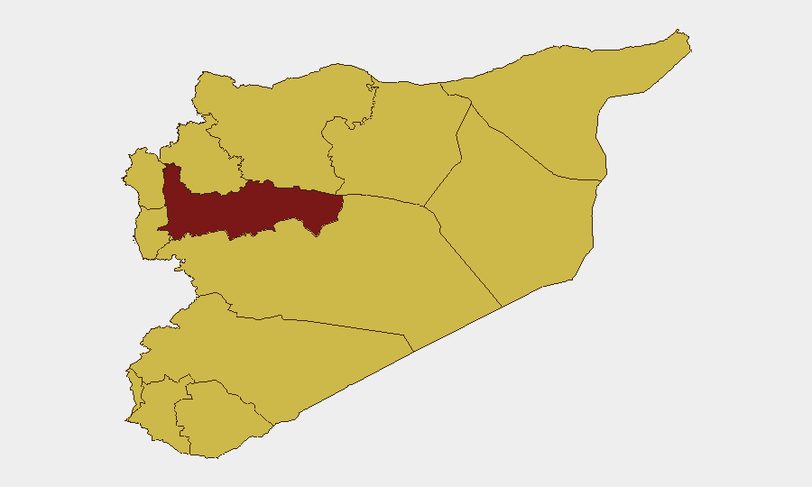
Hama Governorate dominates the risk profile (95.8), driven by overlapping Turkish, regime, and anti-regime military operations and a history of chemical-weapons use and mass detention; Damascus Governorate (71.3) remains high due to regime security services, occasional armed clashes, and checkpoints that create duty-of-care exposure; and Aleppo (67.8) continues to see Turkish-backed opposition control in the north and regime presence in the south, with porous boundaries and sporadic clashes. The cluster of mid-ranked governorates (Lattakia, Rif Dimashq, Tartus, Dar'a, Idlib, Raqqa, Homs—all 65–66) reflects distributed, low-intensity conflict and instability across much of the non-coastal interior and northeast; none is currently a flashpoint, but all remain exposed to rapid escalation.
How GeoBit Would Assist
Intel Sweep and global event feeds provide the baseline tracking and flagging of incidents across Syria, feeding the composite scoring and sub-national risk rankings used here. X/Twitter & Telegram OSINT, multi-language search, and OSINT fusion & corroboration enable real-time identification and de-duplication of emerging security events and actor statements, especially critical when official reporting is opaque or delayed. AOI Monitoring & Early Warning with persistent watch on Hama, Damascus, Aleppo, and other duty-of-care locations allows rapid alerting of new clashes, checkpoints, or security operations that could affect staff movement or supply chains.
7-Day Outlook
No imminent major shift in the conflict balance is signalled; Turkish and regime forces will likely maintain current lines and operational postures. Low-intensity clashes, checkpoint activity, and sporadic ISIS activity in the east will continue. Watch for any sharp increase in arrest campaigns in Damascus or regime-controlled cities—often a precursor to broader security crackdowns—and monitor Turkish air and ground operations in the northwest for potential spillover into civilian areas or key supply routes.
Highest-Risk Areas — Ranked
| # | State / Region | Risk |
|---|---|---|
| 1 | Hama Governorate | 95.8 |
| 2 | Damascus Governorate | 71.3 |
| 3 | Aleppo Governorate | 67.8 |
| 4 | Lattakia Governorate | 66.1 |
| 5 | Rif Dimashq Governorate | 66.1 |
| 6 | Tartus Governorate | 65.8 |
| 7 | UNDOF | 65.8 |
| 8 | Al-Quneitra Governorate | 65.8 |
| 9 | Dar'a Governorate | 65.8 |
| 10 | Idleb Governorate | 65.8 |
| 11 | Ar-Raqqa Governorate | 65.8 |
| 12 | Homs Governorate | 65.8 |
Sources
Previous Daily Briefs
A new Syria brief is written every day — each with its own risk map and downloadable CSV. Here's the last week; use the calendar to go further back.
📅 Browse every day by calendar →
Highlighted days have a brief. Tap a day for that day's map & analysis, or “csv” for that day's dataset ($5).