Situation Summary
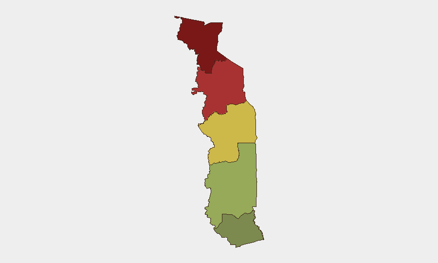
Togo remains a low-to-moderate threat environment globally (rank #59, composite score 21) with no confirmed security incidents in the last 24–48 hours. The country's risk profile is heavily concentrated in its northern border regions—Savanes and Kara—where cross-border activity, resource competition, and proximity to Burkina Faso's instability drive elevated threat scores. The southern maritime and central zones remain substantially lower-risk, though localized weather-related disruptions (flooding, drainage) have affected border communities.
Key Developments
No discrete security or civil unrest incidents were confirmed in Togo within the last 24–48 hours across open-source and social-media channels.
A three-day civil protection exercise, Operation Lignite Coast 2026, was conducted in early July (prior to the current 24–48 hour window) by Togo's National Civil Protection Agency and the North Dakota National Guard in Lomé and coastal areas, focused on disaster-preparedness and incident-response protocols. This was a planned training activity, not a real-world incident.
Ongoing localized context: Border communities along the Ghana–Togo frontier continue to experience drainage and flooding issues following seasonal rains; these are chronic, not acute, developments and do not constitute security incidents.
No travel advisories, critical infrastructure alerts, political instability reports, terrorist activity claims, or major crime incidents were issued or confirmed in the past 48 hours.
Highest-Risk Areas
The Savanes Region (risk 92) and Kara Region (risk 78) drive Togo's overall threat profile, reflecting their proximity to Burkina Faso and the Sahel's broader instability, porous borders, and historical exposure to cross-border militant and trafficking networks. The Centrale Region (risk 65) presents moderate concern, while Plateaux (45) and Maritime (28) regions are substantially lower-risk. Organizations with personnel or assets in the north should maintain heightened situational awareness and contingency protocols; southern and coastal operations face routine rather than elevated exposure.
How GeoBit Would Assist
AOI Monitoring & Early Warning would provide persistent watch over Savanes and Kara regions with automated alerting on security movements, border crossings, or militia activity. OSINT Fusion (Twitter/Telegram, local media, cross-language analysis) combined with Network & Actor Analysis would detect emerging threat actors, smuggling routes, or protest mobilization before they escalate. GIS & Spatial Analysis and Satellite & Imagery Analysis enable tracking of force deployments, camp activity, and infrastructure threats with minimal reliance on public reporting. These tools allow security teams to shift from reactive incident response to predictive posture in high-risk northern zones.
7-Day Outlook
No imminent spike in security incidents is signaled by current intelligence. However, seasonal factors (rainy-season flooding in border areas, cross-border trafficking activity tied to agricultural cycles, and potential militia recruitment in northern zones) remain standing risks. Organizations should expect baseline northern-region exposure to persist; any material escalation would likely be preceded by social-media chatter, humanitarian alerts, or diplomatic warnings that GeoBit's monitoring infrastructure could detect in real-time.
Highest-Risk Areas — Ranked
| # | State / Region | Risk |
|---|---|---|
| 1 | Savanes Region | 92 |
| 2 | Kara Region | 78 |
| 3 | Centrale Region | 65 |
| 4 | Plateaux Region | 45 |
| 5 | Maritime Region | 28 |
Sources
Previous Daily Briefs
A new Togo brief is written every day — each with its own risk map and downloadable CSV. Here's the last week; use the calendar to go further back.
📅 Browse every day by calendar →
Highlighted days have a brief. Tap a day for that day's map & analysis, or “csv” for that day's dataset ($5).
Atlas — our AI intelligence desk — emails them this snapshot personally. Nothing else, no list.