Situation Summary
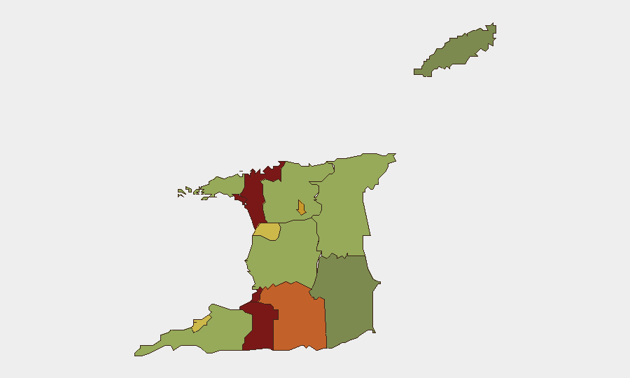
Trinidad and Tobago remains a lower-tier global security concern (composite threat score 16), with no major nationwide crises reported in open sources over the past 24–48 hours. However, sub-national risk is highly concentrated in urban and gang-affected zones, particularly San Juan-Laventille (risk 95) and Port of Spain (risk 88), where gang violence, extortion, and armed robbery remain persistent drivers of corporate and personal security exposure. The security environment is stable at the macro level but operationally fragmented—risk is acute in specific neighborhoods and transport corridors, not diffuse across the country.
Key Developments
No specific, verifiable security incidents in Trinidad and Tobago dating to 21–22 June 2026 could be cross-confirmed from available open-source channels. Routine police operations (arrests, warrant exercises) are reported regularly by the Trinidad and Tobago Police Service (TTPS), but the most recent publicly available media release visible to GeoBit intelligence sources is dated 19 June 2026—outside the current 24–48-hour window. No large-scale civil unrest, infrastructure disruption, or national-level emergency declarations are evident in global news or social media indexed to the last two days. Local crime incidents (shootings, robberies, gang clashes) occur regularly in high-risk zones but are typically reported with lag on official channels and fragmented across local media.
Highest-Risk Areas
Four zones dominate Trinidad and Tobago's internal risk profile: San Juan-Laventille (95), Port of Spain (88), Penal-Debe (82), and San Fernando (80). These areas are hubs of gang activity, turf disputes, and armed crime; San Juan-Laventille in particular is synonymous with organized violence and extortion targeting both residents and transit users. Port of Spain, the capital and commercial center, combines high foot traffic with active criminal networks, making it a flashpoint for kidnapping, robbery, and carjacking. Mid-tier risk zones (Arima, Chaguanas, Point Fortin) see lower absolute incident density but remain secondary concern areas for companies with supply chains or personnel in those regions. Lower-risk areas (Diego Martin, Sangre Grande, Couva) offer relatively safer operational environments but are not immune to criminal activity.
How GeoBit Would Assist
Security teams should deploy AOI Monitoring & Early Warning on San Juan-Laventille, Port of Spain, San Fernando, and transport corridors (Beetham Highway, Churchill-Roosevelt) to receive alerting on emerging gang activity, roadblocks, or unrest. X/Twitter and social OSINT (geolocated posts, community alerts, TTPS media releases) combined with sentiment and temporal analysis will provide real-time ground truth on incidents, protests, and disruptions faster than traditional news cycles. Routing & Network Analysis enables duty-of-care teams to model and pre-clear alternative routes for personnel and asset movements away from known hotspots.
7-Day Outlook
No major escalation is anticipated in the next seven days based on available indicators. Gang-driven street crime will continue at baseline rates in high-risk zones; seasonal rainfall (June–November) may briefly disrupt transport but poses no acute security threat. Corporate teams should maintain elevated situational awareness in San Juan-Laventille, Port of Spain, and San Fernando while leveraging real-time OSINT monitoring for early warning of any cluster of incidents that could signal a localized escalation.
Highest-Risk Areas — Ranked
| # | State / Region | Risk |
|---|---|---|
| 1 | San Juan-Laventille | 95 |
| 2 | Port of Spain | 88 |
| 3 | Penal-Debe | 82 |
| 4 | San Fernando | 80 |
| 5 | Princes Town | 75 |
| 6 | Arima | 72 |
| 7 | Chaguanas | 68 |
| 8 | Point Fortin | 65 |
| 9 | Diego Martin | 58 |
| 10 | Siparia | 55 |
| 11 | Couva-Tabaquite-Talparo | 52 |
| 12 | Sangre Grande | 48 |
Previous Daily Briefs
A new Trinidad and Tobago brief is written every day — each with its own risk map and downloadable CSV. Here's the last week; use the calendar to go further back.
📅 Browse every day by calendar →
Highlighted days have a brief. Tap a day for that day's map & analysis, or “csv” for that day's dataset ($5).