Situation Summary
Mauritania's overall security threat profile remains low (composite score 23), with no credible reports of armed conflict, terrorism, or major civil unrest in the last 24–48 hours. The immediate security landscape is dominated by a severe maritime migration crisis unfolding off the Atlantic coast, with multiple boat incidents resulting in over 140 dead or missing and ongoing search-and-rescue operations straining coastal infrastructure. Secondary disruption from flooding on the Route de l'Espoir in central Mauritania has paralyzed a key east–west transport corridor, while minor parliamentary disciplinary actions reflect routine domestic political friction.
Key Developments
- Off Nouakchott, Atlantic coast (14–18 July, reported 21 July): A migrant vessel from The Gambia carrying ~160 people ran out of fuel and drifted for 25 days; Mauritanian coast guard rescued 37–38 survivors; approximately 120–143 are dead or missing. UNHCR and national authorities coordinated three disembarkations in Nouakchott and Nouadhibou between 14–18 July, bringing 387 migrants ashore safely.
- Off Mauritania's Atlantic coast (18 July, reported 18–21 July): Coast guard rescued 179 migrants from a boat that departed Senegal bound for the Canary Islands; no deaths reported in this operation, but hospital evacuations and processing underway.
- Route de l'Espoir, El Ghaïra, Assaba region (mid-July, ongoing): Heavy flooding has caused complete closure of a section of this main east–west highway, creating significant logistical and travel disruption for central and southern regions.
- National Assembly, Nouakchott (17 July, reported in last 48h): Parliament's president signed a disciplinary decision imposing temporary exclusion and censure on two deputies (Mariem Cheikh Samba Dieng and Ghamou Achour Salem) for breaching parliamentary discipline; no public unrest reported.
- Maritime SAR operations ongoing: Multiple concurrent search-and-rescue events off the Atlantic coast confirm sustained irregular migration flows and indicate continued pressure on port infrastructure, health services, and security/immigration systems in Nouakchott and Nouadhibou.
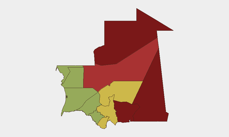
Highest-Risk Areas
Tiris Zemmour (risk 95) and the eastern border regions—Hodh Ech Chargui (85) and Hodh El Gharbi (80)—remain the highest-risk zones, driven primarily by proximity to conflict spillover from Mali and Algeria and porous border management. Adrar (78) and Tagant (68) follow, reflecting similar cross-border vulnerabilities and sparse state presence. Coastal and central regions (Trarza, Assaba, Brakna) carry moderate risk (55–62), concentrated on maritime irregularities, flood-related disruption, and humanitarian pressures rather than armed instability. The capital region and northern port cities, while lower-ranked, are experiencing acute operational strain from the current migration crisis.
How GeoBit Would Assist
Security teams with personnel or assets in Mauritania would prioritize AOI Monitoring & Early Warning for coastal disembarkation sites (Nouakchott, Nouadhibou) and the Route de l'Espoir corridor to track SAR operations and transport disruptions in real time. Maritime & Aviation tracking and OSINT fusion (cross-checking X/Twitter, local news, and agency feeds) enable early detection of new migrant-vessel incidents and casualty trends before operational impact. Alternative route and network analysis tools support contingency planning for staff transit and supply chains vulnerable to flooding or port congestion during mass disembarkations.
7-Day Outlook
Maritime migration incidents are likely to persist through the remainder of July, sustained by seasonal sea conditions and ongoing irregular flows from West Africa toward Europe. Flooding on the Route de l'Espoir is expected to remain a constraint on east–west transport; repair timelines are not yet confirmed. No significant escalation in armed conflict, terrorism, or political unrest is forecast for the next 7 days, though continued coast-guard operations and humanitarian coordination may generate localized security activity and service disruptions in major port cities.
Highest-Risk Areas — Ranked
| # | State / Region | Risk |
|---|---|---|
| 1 | Tiris Zemmour | 95 |
| 2 | Hodh Ech Chargui | 85 |
| 3 | Hodh El Gharbi | 80 |
| 4 | Adrar | 78 |
| 5 | Tagant | 68 |
| 6 | Guidimaka | 65 |
| 7 | Assaba | 62 |
| 8 | Gorgol | 58 |
| 9 | Trarza | 55 |
| 10 | Inchiri | 52 |
| 11 | Brakna | 48 |
| 12 | Dakhlet Nouadhibou | 45 |
Sources
Previous Daily Briefs
A new Mauritania brief is written every day — each with its own risk map and downloadable CSV. Here's the last week; use the calendar to go further back.
📅 Browse every day by calendar →
Highlighted days have a brief. Tap a day for that day's map & analysis, or “csv” for that day's dataset ($5).
Atlas — our AI intelligence desk — emails them this snapshot personally. Nothing else, no list.