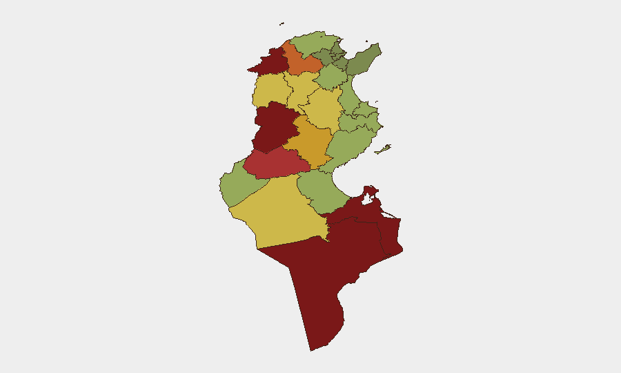
Situation Summary
Tunisia remains in a volatile political and socioeconomic environment characterized by civil unrest, media suppression, and labor-union activism. The week of October 14–20 saw the largest anti-government demonstration in years, alongside ongoing arrests of activists and journalists, signaling deepening friction between the regime and civil society. The national threat ranking (score 28, #76 globally) reflects moderate risk with civil unrest as the primary driver; however, sub-national disparities are acute, with western and southern border regions significantly more unstable than the capital.
Key Developments
- Tunis, 14 October: Court released activists Aya Sadraoui and Ghaith Hamrouni after detention related to Palestine-solidarity marching, marking one of few documented releases during an otherwise restrictive period.
- Tunisia, nationwide, 14 October: Reuters documented approximately 20 journalists facing criminal charges for reporting or social-media activity, with four already imprisoned; reflects a documented escalation in press restrictions.
- Tunis, 17 October: Thousands participated in the largest anti-President Kais Saied protest in years, organized by the UGTT trade-union federation and civil-society coalitions; demonstrators cited democratic restrictions, economic mismanagement, arrest of critics, and attacks on labor rights.
- Tunis, 17 October: Police deployed hundreds of officers and imposed closures and movement restrictions across parts of the capital in response to the demonstration; no major violence reported, but heavy security posture evident.
- Métlaoui and Mdhilla, Gafsa Governorate, 14 October: Security operations arrested multiple wanted suspects for theft, attempted murder, drug trafficking, and fraud; authorities recovered cannabis, 34 narcotic pills, and drug-packaging equipment, indicating ongoing organized-crime activity in western regions.
- Background context: Prior-week events (7–9 October) included riots over living conditions in Sidi Bouzid (police response with tear gas) and police blockades of unemployed-graduate protests attempting to reach central authorities; these predate the current reporting window but underscore sustained youth mobilization and economic grievance.
Highest-Risk Areas
Western and southern border governorates dominate the sub-national risk profile. Kasserine (risk 92), Jendouba (88), and Tataouine (85) are the acute concern zones, followed by Médenine and Gafsa (78). These regions are driven by a combination of geographic isolation, weaker state capacity, economic marginalization, cross-border trafficking networks, and historical grievances. Kasserine in particular has been a flashpoint for youth unrest and irregular-migration tensions. By contrast, central and coastal zones remain comparatively stable, though Tunis itself has become a focal point for organized political protest.
How GeoBit Would Assist
Security and duty-of-care teams would employ AOI Monitoring & Early Warning to track protest activity and police deployments in Tunis and key cities on a persistent basis, with real-time alerting for closure or curfew declarations. Intel Sweep and multi-language OSINT fusion (X/Twitter, Telegram, YouTube) would provide early signals of planned demonstrations or labor actions before they materialize. Risk & Threat Assessment and GIS & Spatial Analysis would enable teams to differentiate risk by governorate—critical for route planning and asset positioning—while Routing & Network Analysis would support alternative-journey planning around active protest zones or security cordons.
7-Day Outlook
The October 17 demonstration signals widening civil discontent and will likely embolden further labor and activist mobilization in the coming weeks. Media crackdowns and activist arrests may accelerate, increasing the temperature in Tunis. Western and southern regions will continue to be the primary source of localized unrest, crime, and trafficking-related security incidents; monitoring these zones for spillover toward central regions remains a priority.
Highest-Risk Areas — Ranked
| # | State / Region | Risk |
|---|---|---|
| 1 | Kasserine | 92 |
| 2 | Jendouba | 88 |
| 3 | Tataouine | 85 |
| 4 | Médenine | 83 |
| 5 | Gafsa | 78 |
| 6 | Béja | 75 |
| 7 | Sidi Bouzid | 72 |
| 8 | Al Kaf | 70 |
| 9 | Kébili | 68 |
| 10 | Kairouan | 65 |
| 11 | Siliana | 62 |
| 12 | Tozeur | 58 |
Sources
Previous Weekly Briefs
A new Tunisia brief is written every Monday, covering the week — each with its own risk map and downloadable CSV. Use the calendar to go further back.
- October 13, 2026
- October 6, 2026
- September 29, 2026
- September 22, 2026
- September 15, 2026
- September 8, 2026
- September 2, 2026
📅 Browse past briefs by calendar →
Highlighted days have a brief. Tap a day for that day's map & analysis, or “csv” for that day's dataset ($5).
Atlas — our AI intelligence desk — emails them this snapshot personally. Nothing else, no list.