Situation Summary
Angola remains a moderate regional security concern (global ranking #46, composite threat score 48) with a fragmented geographic risk profile dominated by one critically elevated zone. No major security incidents, armed clashes, civil unrest, or infrastructure disruptions have been independently confirmed in the past 24–48 hours. Current reporting emphasizes commercial activity (offshore energy development) rather than acute threat developments. The country's overall trajectory remains stable, though localized vulnerabilities in border and resource-extraction zones warrant sustained monitoring.
Key Developments
No credible, independently corroborated security, conflict, or civil-unrest incidents meeting the 24–48-hour window have been identified in Angola from open-source, newswire, or diplomatic channels.
Note on recent signals: Two "public statement" events flagged by the GeoBit platform (both 2026-06-26, Angola vs. Africa) and a recent cholera event remain unconfirmed by mainstream sources and lack sufficient detail for operational assessment at this time. Web research did not surface verification of these signals in credible sources. A routine health monitoring alert regarding cholera presence in Angola should be tracked but does not constitute an acute security event.
Recent open-source coverage (Baker Hughes offshore systems award, June 25) reflects commercial energy development rather than security risk.
Highest-Risk Areas
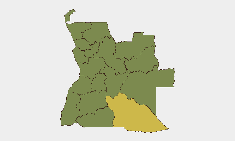
Cuando Cubango Province significantly exceeds all other regions (risk score 63.8 versus 33.8 baseline for all others), indicating a distinct and concentrated threat driver in Angola's southwestern border zone. The disparity warrants focused investigation into the underlying risk vectors—likely involving cross-border activity, resource-sector vulnerabilities, or localized instability—but current reporting does not identify specific active incidents in that province in the past 48 hours. The remaining eleven provinces cluster at uniform moderate risk (33.8), suggesting either broadly distributed lower-level concerns or data-aggregation effects. Luanda, the capital, ranks alongside secondary provinces rather than standing apart, indicating that capital-city security remains within the national mean rather than elevated.
How GeoBit Would Assist
Corporate security teams with operations or personnel in Angola—particularly in Cuando Cubango, the Lundas, or Cabinda—should employ Area-of-Interest (AOI) Monitoring & Early Warning for persistent watch and alert triggers on localized incidents. Intel Sweep and multi-language OSINT fusion (including X/Twitter, Telegram, and regional media) can bridge current gaps in corroboration of the platform's unconfirmed signals and establish timeline and severity. GIS & Spatial Analysis and Satellite & Imagery capabilities support route-risk assessment and asset-location verification in remote or high-risk zones, complementing traditional travel advisories.
7-Day Outlook
No acute escalation is anticipated in the next 7 days based on available indicators. Monitoring should remain focused on the Cuando Cubango risk anomaly and on verification of the platform's unconfirmed June 26 signals; if those resolve to genuine incidents, risk trajectory may require revision. Routine cholera surveillance should continue; if community spread or healthcare disruption occurs, humanitarian and operational planning may need adjustment.
Highest-Risk Areas — Ranked
| # | State / Region | Risk |
|---|---|---|
| 1 | Cuando Cubango Province | 63.8 |
| 2 | Lunda Norte Province | 33.8 |
| 3 | Lunda Sul Province | 33.8 |
| 4 | Cabinda Province | 33.8 |
| 5 | Zaire Province | 33.8 |
| 6 | Bengo Province | 33.8 |
| 7 | Luanda Province | 33.8 |
| 8 | Uíge Province | 33.8 |
| 9 | Cuanza Norte Province | 33.8 |
| 10 | Cuanza Sul Province | 33.8 |
| 11 | Malanje Province | 33.8 |
| 12 | Bié Province | 33.8 |
Sources
Previous Daily Briefs
A new Angola brief is written every day — each with its own risk map and downloadable CSV. Here's the last week; use the calendar to go further back.
📅 Browse every day by calendar →
Highlighted days have a brief. Tap a day for that day's map & analysis, or “csv” for that day's dataset ($5).