Situation Summary
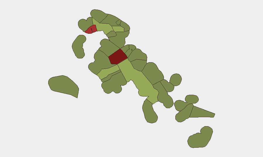
The Bahamas presents a composite threat profile dominated by localized crime concentration in Nassau (New Providence) and Freeport (Grand Bahama), with no active civil unrest, political instability, or systemic infrastructure failure as of 21 July 2026. The security environment is characterized by routine armed robbery and gang violence rather than organized unrest, though recent isolated safety incidents—including a fatal hit-and-run with armed police engagement, a multi-vehicle crash on a critical transport link, and ongoing aviation capacity degradation—indicate fragmented vulnerabilities across transport and public safety. The national threat trajectory remains stable but operationally constrained by inter-island aviation disruption stemming from the 10 July Flamingo Air crash.
Key Developments
- New Providence, Carmichael Road (southwest Nassau) – Fatal hit-and-run with armed police response
Date: 19 July 2026. A 59-year-old male was fatally struck in an apparent hit-and-run incident; police engaged in a gunfire exchange while pursuing suspects, resulting in one arrest. The incident underscores active armed-crime risk in Nassau's southwestern neighborhoods and required emergency armed response.
- New Providence, Sir Sidney Poitier Bridge – Multi-vehicle crash from brake failure
Date: 17 July 2026. A Mack truck with failed brakes caused a pile-up involving multiple vehicles and toll-booth infrastructure on this key access route to Paradise Island. No serious injuries were reported, but the event highlighted heavy-vehicle safety gaps and disrupted a critical inter-island transport chokepoint.
- Bimini, North Bimini – Occupational electrocution fatality
Date: 18 July 2026. A 68-year-old worker died from contact with a high-voltage electrical transformer while painting; the incident raises occupational-safety and infrastructure-integrity concerns affecting routine work operations on outer islands.
- Nationwide inter-island aviation – Persistent capacity degradation
Status: Ongoing impact as of 21 July 2026, stemming from the 10 July Flamingo Air Cessna 402 crash (10 fatalities). Replacement lift remains unrestored, continuing to degrade transport reliability and travel-planning feasibility across the archipelago in the current operational window.
- Green Turtle Cay, Abaco (Gillam Bay) – Community opposition to coastal development
Reported within 48 hours. Residents have voiced strong concerns over a proposed development lacking prior consultation and environmental safeguards. While not violent, this reflects localized socio-environmental tension with potential for escalation to legal challenge or protest activity.
Highest-Risk Areas
New Providence (risk 92) and Freeport (risk 78) drive national risk primarily through endemic armed robbery, gang-affiliated violence, and routine homicide concentrated in informal settlements and nighttime commercial districts. Central Abaco (52), Central Andros (48), and Exuma (45) register elevated scores tied to inter-island connectivity vulnerability, limited law-enforcement presence, and economic fragility. The sub-national ranking reflects both active crime intensity and geographic isolation from rapid-response resources.
How GeoBit Would Assist
Teams operating in-country would deploy Intel Sweep and global event feeds for continuous 24-48-hour incident detection in Nassau and Freeport; AOI Monitoring & Early Warning on high-risk neighborhoods and critical infrastructure (Sir Sidney Poitier Bridge, inter-island aviation hubs); and Routing & Network Analysis to identify secure alternative transport corridors during disruptions. Maritime & Aviation tracking would provide real-time visibility on inter-island service restoration and capacity constraints affecting duty-of-care compliance.
7-Day Outlook
No escalation in civil unrest or political instability is forecast over the next seven days. Operational risk will remain driven by routine crime in urban centers, inter-island transport constraints (until aviation capacity recovers), and isolated infrastructure-safety incidents. Security teams should maintain standard crime-avoidance protocols in Nassau and Freeport while monitoring Flamingo Air replacement service schedules.
Highest-Risk Areas — Ranked
| # | State / Region | Risk |
|---|---|---|
| 1 | New Providence | 92 |
| 2 | City of Freeport | 78 |
| 3 | Central Abaco | 52 |
| 4 | Central Andros | 48 |
| 5 | Exuma | 45 |
| 6 | East Grand Bahama | 42 |
| 7 | South Andros | 38 |
| 8 | North Abaco | 35 |
| 9 | North Eleuthera | 33 |
| 10 | South Abaco | 32 |
| 11 | Cat Island | 30 |
| 12 | Mangrove Cay | 28 |
Previous Daily Briefs
A new Bahamas brief is written every day — each with its own risk map and downloadable CSV. Here's the last week; use the calendar to go further back.
📅 Browse every day by calendar →
Highlighted days have a brief. Tap a day for that day's map & analysis, or “csv” for that day's dataset ($5).
Atlas — our AI intelligence desk — emails them this snapshot personally. Nothing else, no list.