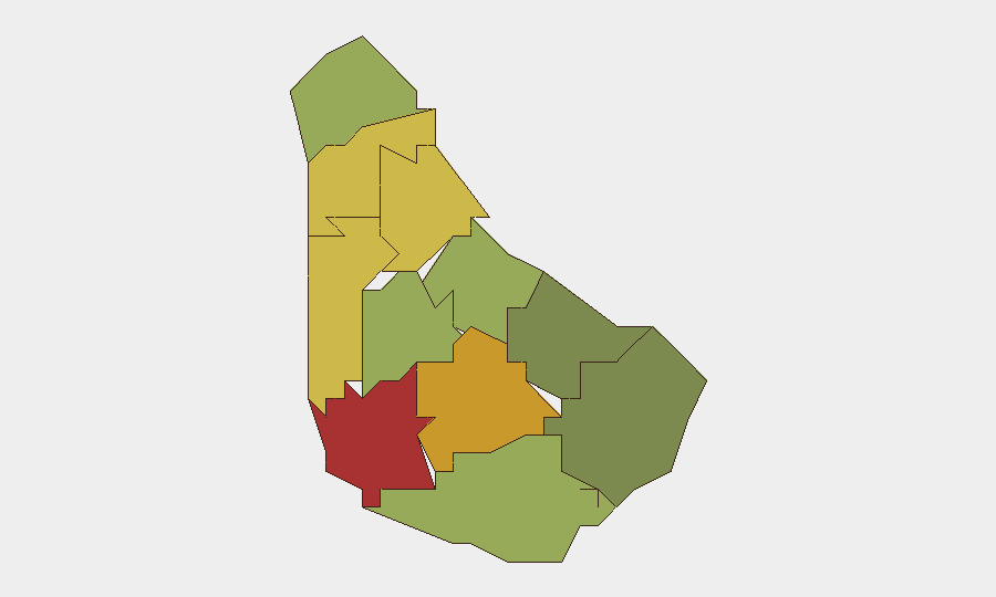
Situation Summary
Barbados remains in a stable, low-threat operating environment with no validated acute security, civil-unrest, or infrastructure incidents recorded in the last 48 hours. The composite threat score of 13 places the island in the global low-risk tier. Security forces are conducting heightened festival policing operations ahead of Crop Over Grand Kadooment, a planned measure rather than a reactive response to incident escalation.
Key Developments
- Bridgetown & Island-wide – 27–28 July 2026 – No acute incidents detected. Consolidated security monitoring across web research, social media, and event feeds confirms a stable security environment with no validated security, crime spikes, civil unrest, or infrastructure disruptions in the 48-hour window.
- Eagle Hall Junction, Black Rock Main Road, Holders Land (Saint Michael) – Late July 2026 – Barbados Police Service and Barbados Defence Force announced joint security operations for Crop Over Festival climax. Measures include drone and CCTV surveillance, checkpoint deployment, traffic diversions, and rapid-response teams. This represents planned festival security, not incident-driven response.
- Island-wide – Late July 2026 – Barbados Water Authority issued a cyber-fraud alert regarding a fraudulent TikTok account ("Barbados Water Works") impersonating the authority and falsely claiming bill-payment capabilities via PayPal. The alert highlights emerging online fraud targeting residents and advises reporting the account to authorities.
- Christ Church – Late July 2026 – Police investigation launched following the death of 21-year-old Cammeron Ifill by shooting. Temporal confirmation places this at the margin of the 48-hour window; included as a recent development pending clearer time-stamping.
- Belfield, Saint Michael – Late July 2026 – Local reporting notes a fatal shooting with unclear timestamp. Included as a possible recent incident but cannot be firmly validated within the specified 48-hour period.
Highest-Risk Areas
Saint Michael (risk 78) and Saint George (risk 72) anchor the sub-national threat ranking, reflecting urban concentration, population density, and baseline crime patterns in and around Bridgetown. Saint James (68) and Saint Andrew (65) follow, suggesting that northern and western parishes carry elevated exposure to underlying crime and social-friction factors. The risk gradient descends sharply toward southern and eastern parishes (Saint Philip at 28, Saint John at 35), indicating that risk is geographically concentrated in the more densely populated western corridor. Organizations with personnel or assets in Saint Michael and Saint George should maintain heightened situational awareness despite the current stable operational picture.
How GeoBit Would Assist
Teams operating in Barbados should deploy AOI Monitoring & Early Warning on high-risk parishes—particularly Saint Michael, Saint George, and Saint James—to detect emerging crime clusters or civil-unrest signals before escalation. Intel Sweep and X/Twitter OSINT capabilities provide real-time detection of breaking incidents, fraud campaigns, and public-safety advisories (as exemplified by the recent BWA fraud alert). Risk & Threat Assessment modules enable ongoing duty-of-care evaluation as Crop Over activities conclude and routine policing patterns reassert.
7-Day Outlook
Barbados is forecast to remain in a low-threat posture over the next week. Crop Over festival operations will continue to draw enhanced police and defence-force deployment, creating temporary traffic and movement constraints in Bridgetown and western parishes but not materially elevating security risk. Baseline crime patterns and online-fraud activity are expected to persist at routine levels.
Highest-Risk Areas — Ranked
| # | State / Region | Risk |
|---|---|---|
| 1 | Saint Michael | 78 |
| 2 | Saint George | 72 |
| 3 | Saint James | 68 |
| 4 | Saint Andrew | 65 |
| 5 | Saint Peter | 62 |
| 6 | Saint Joseph | 58 |
| 7 | Saint Thomas | 52 |
| 8 | Saint Lucy | 48 |
| 9 | Christ Church | 42 |
| 10 | Saint John | 35 |
| 11 | Saint Philip | 28 |
Sources
Previous Daily Briefs
A new Barbados brief is written every day — each with its own risk map and downloadable CSV. Here's the last week; use the calendar to go further back.
📅 Browse every day by calendar →
Highlighted days have a brief. Tap a day for that day's map & analysis, or “csv” for that day's dataset ($5).
Atlas — our AI intelligence desk — emails them this snapshot personally. Nothing else, no list.