Situation Summary
Belize remains a structurally high-crime environment concentrated in urban centers, particularly Belize City and Orange Walk District, but the country is currently experiencing routine baseline conditions with no acute civil, political, or security crisis. The past 24–48 hours have been marked by infrastructure disruption (ISP outages) and routine administrative developments rather than conflict or violence escalation. No new mass-casualty incidents, large-scale protests, or border emergencies have emerged in current reporting, and the security posture remains stable relative to historical norms for the country.
Key Developments
- National (27 July, 2026) – Major ISPs BTL and SMART experienced intermittent outages affecting nationwide connectivity; both providers acknowledged service disruptions with no indication of sabotage or malicious intent. Business operations and emergency communications may experience localized delays.
- Belize Rural Central (past 48 hours) – A UDP political candidate filed a corruption complaint against sitting PUP area representative Oscar Mira with the Integrity Commission; confined to administrative/political channels with no associated public unrest or protest activity reported.
- Belmopan (late July, concluded) – Over 40 emergency-response personnel (BDF, Coast Guard, National Fire Service, BSAR Institute) completed a week-long CARICOM Disaster Relief Unit training programme on hurricane-season readiness; reflects improved civil-protection capacity ahead of Atlantic storm season.
- Cayo District (current cycle) – A case of animal abuse went viral nationally; authorities and rescuers intervened and secured the animal. Minor public-order relevance but no civil unrest or organized response.
- Baseline crime status – No new, verifiable shootings or gang violence incidents have been reported in the past 24–48 hours; however, Belize City and Orange Walk District remain structurally elevated risk zones driven by gang and trafficking activity (most recent dated escalation was 8 July, outside the current reporting window).
Highest-Risk Areas
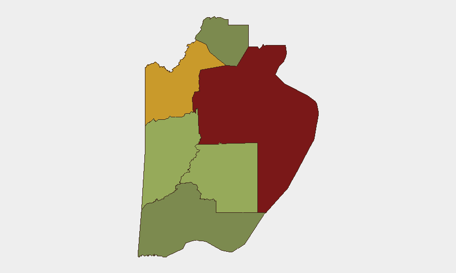
Belize District (risk score 95) and Orange Walk District (risk score 72) remain the country's primary security drivers, both characterized by chronic gang presence, inter-cartel competition, and trafficking routes. Cayo District (58) carries moderate-elevated risk linked to rural gang activity and cross-border movement; Stann Creek, Toledo, and Corozal districts pose lower but non-negligible threat levels. Urban concentration of risk means corporate and NGO personnel in Belmopan, San Ignacio, and particularly Belize City should maintain heightened awareness; rural and peripheral zones present lower day-to-day hazard but require updated routing and communications protocols during hurricane season.
How GeoBit Would Assist
Security teams with personnel or assets in Belize would benefit from GeoBit's AOI Monitoring & Early Warning capability to track Belize City and Orange Walk District for emerging gang or trafficking escalation; Intel Sweep and OSINT Fusion to correlate local news, social media, and law-enforcement signals for early indication of violence or unrest; and Routing & Network Analysis to identify secure transit corridors and backup routes around high-risk urban zones. Persistent monitoring during hurricane season can also integrate Environmental & Health and Humanitarian data to anticipate displacement or service disruption.
7-Day Outlook
No acute security deterioration is anticipated in the next 7 days. Attention should focus on restoration of ISP services, ongoing hurricane-season preparedness, and routine monitoring of Belize City gang activity. The political-integrity complaint filed in Belize Rural Central is unlikely to generate escalated tension absent broader institutional stress.
Highest-Risk Areas — Ranked
| # | State / Region | Risk |
|---|---|---|
| 1 | Belize District | 95 |
| 2 | Orange Walk District | 72 |
| 3 | Cayo District | 58 |
| 4 | Stann Creek District | 48 |
| 5 | Toledo District | 35 |
| 6 | Corozal District | 22 |
Sources
Previous Daily Briefs
A new Belize brief is written every day — each with its own risk map and downloadable CSV. Here's the last week; use the calendar to go further back.
📅 Browse every day by calendar →
Highlighted days have a brief. Tap a day for that day's map & analysis, or “csv” for that day's dataset ($5).
Atlas — our AI intelligence desk — emails them this snapshot personally. Nothing else, no list.