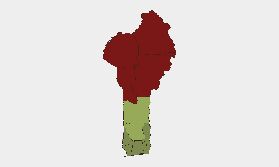
Situation Summary
Benin remains stable at the national level with no acute security incidents reported in the last 24–48 hours. The country's composite threat score of 43 places it in the lower-risk range globally; no discrete events are currently tracked. However, sustained sub-national volatility in the northern departments—particularly Alibori, Atakora, Donga, and Borgou—reflects ongoing exposure to transnational militant activity, cross-border trafficking, and spillover from regional conflicts in the Sahel. Southern coastal zones remain comparatively secure, though Gulf of Guinea maritime risk persists.
Key Developments
- Brussels, Belgium – 24 June 2026
High-level political engagement: the President of Benin met with the European Council President. This reflects diplomatic activity but carries no direct security implications for on-ground operations in Benin.
- Gulf of Guinea Maritime Advisory – Standing (not within 24–48h window)
U.S. maritime authorities maintain persistent piracy, armed robbery, and kidnapping warnings for vessels off Benin and neighboring Gulf of Guinea states. Most recent specific incidents cited (March 2026) fall outside the current reporting window; this is a chronic rather than acute development.
- No internal security incidents reported 23–25 June 2026
Extensive monitoring of news wires, regional outlets, social media, and official advisories confirms no terrorist attacks, major violent crime, protests, infrastructure disruptions, or new travel warnings specific to Benin in this period.
Highest-Risk Areas
Northern departments—Alibori (92), Atakora (88), Donga (85), and Borgou (83)—account for the highest composite risk scores and drive the country's overall security picture. These zones are contiguous with Burkina Faso and Mali, where militant franchises (including JNIM and ISIS-aligned groups) operate; cross-border incursions, trafficking, and recruitment activity persist. Southern departments (Littoral, Ouémé, Atlantique) score significantly lower (22–28), reflecting urban stability and lower militant presence, though maritime crime risks apply to coastal operations. Zou and Collines departments occupy a middle band (42–45), suggesting moderate localized instability or criminal activity.
How GeoBit Would Assist
AOI Monitoring & Early Warning should be established on Alibori, Atakora, and Donga departments to detect cross-border militant movements or trafficking activity with automated alerting. OSINT Fusion (multi-language social media, news feeds, entity extraction, sentiment analysis) would provide real-time visibility on emerging protests, civil unrest, or recruitment campaigns in northern zones. Routing & Network Analysis would support duty-of-care teams in planning alternative routes for personnel or cargo movements, circumventing highest-risk corridors. For maritime operations, Maritime Tracking combined with Event Feed Integration would flag piracy reports and vessel incidents in the Gulf of Guinea in real time.
7-Day Outlook
No acute security escalation is forecast for the next seven days. Benin's northern departments will likely maintain baseline sub-national risk (militant/trafficking activity without major tactical shifts), while southern and coastal zones remain operationally stable. Personnel and asset movements should continue to apply standing northern-zone precautions; maritime transits require Gulf of Guinea advisory awareness.
Highest-Risk Areas — Ranked
| # | State / Region | Risk |
|---|---|---|
| 1 | Alibori Department | 92 |
| 2 | Atakora Department | 88 |
| 3 | Donga Department | 85 |
| 4 | Borgou Department | 83 |
| 5 | Zou Department | 45 |
| 6 | Collines Department | 42 |
| 7 | Plateau Department | 38 |
| 8 | Kouffo Department | 35 |
| 9 | Mono Department | 32 |
| 10 | Atlantique Department | 28 |
| 11 | Littoral | 25 |
| 12 | Ouémé Department | 22 |
Sources
Previous Daily Briefs
A new Benin brief is written every day — each with its own risk map and downloadable CSV. Here's the last week; use the calendar to go further back.
📅 Browse every day by calendar →
Highlighted days have a brief. Tap a day for that day's map & analysis, or “csv” for that day's dataset ($5).