Situation Summary
Bhutan remains a low-threat environment with a composite security score of 2 globally and no confirmed conflict, civil unrest, or major crime incidents in the last 24–48 hours. The primary near-term risk is natural hazard–driven rather than human security: very heavy rainfall across the country from 20–23 June has elevated flood and landslide risk, particularly in southern and central districts, with potential for road, bridge, and infrastructure disruption. Overall security trajectory remains stable; natural-hazard management and monsoon-season travel planning are the operative duty-of-care priorities.
Key Developments
- Countrywide – 20–23 June 2026 – Severe weather alert: Bhutan is under elevated flood and landslide risk due to very heavy rainfall expected through 23 June. Impact zones include southern and central districts where monsoon effects are most acute. Road access and rural connectivity may be temporarily compromised.
- No new conflict, unrest, or crime incidents reported: Major international wires, regional South Asia news outlets, and security monitoring channels show no new reports of protests, political violence, cross-border clashes, terrorism, or significant criminal activity in Bhutan as of 23 June.
- One flagged event under investigation (2026-06-21): GeoBit's platform flagged one event on 21 June; details and status remain under investigation and will be reported once corroborated.
Highest-Risk Areas
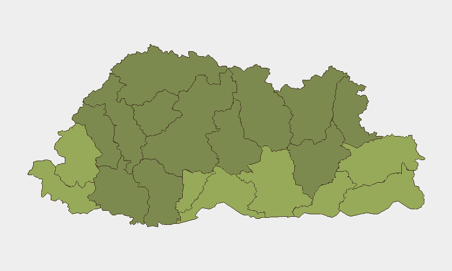
Samtse, Sarpang, and Haa districts (risk scores 58, 55, and 52 respectively) are the highest-risk sub-national zones, driven primarily by their southern and western border proximity and historical susceptibility to monsoon-season infrastructure disruption. Pemagatshel and Samdrup Jongkhar (scores 50 and 48) follow, reflecting similar geography and seasonal weather exposure. These rankings reflect natural-hazard and seasonal infrastructure risk rather than acute political or conflict drivers; however, remote border terrain and limited road redundancy mean that disruptions in these zones can isolate communities and hamper supply chains. Northern districts (Gasa, Lhuntse) show lower composite risk, reflecting less monsoon intensity and lower cross-border traffic exposure.
How GeoBit Would Assist
Security and risk teams with personnel or assets in Bhutan should deploy AOI (Area-of-Interest) Monitoring & Early Warning on high-risk southern and central districts to receive real-time alerts on weather, infrastructure disruption, or emerging security signals. Routing & Network Analysis can identify alternative travel corridors and supply-chain redundancies ahead of monsoon-season road closures. Continuous Intel Sweep and multi-language OSINT across local news, social media, and regional feeds will provide early warning of any shift in the threat baseline, particularly around border areas where geopolitical dynamics warrant persistent watch.
7-Day Outlook
Heavy rainfall is forecast to persist through 23 June, with gradual stabilization expected thereafter; road conditions in southern districts should begin to normalize by 24–25 June, though secondary landslide risk may remain elevated for 48 hours post-rainfall. No escalation of political, security, or conflict risks is anticipated based on current reporting. Duty-of-care focus should remain on travel planning, asset/personnel location safety during the rainfall window, and supply-chain continuity.
Highest-Risk Areas — Ranked
| # | State / Region | Risk |
|---|---|---|
| 1 | Samtse District | 58 |
| 2 | Sarpang District | 55 |
| 3 | Haa District | 52 |
| 4 | Pemagatshel District | 50 |
| 5 | Samdrup Jongkhar District | 48 |
| 6 | Tsirang District | 45 |
| 7 | Zhemgang District | 42 |
| 8 | Trashigang District | 40 |
| 9 | Mongar District | 38 |
| 10 | Gasa District | 35 |
| 11 | Lhuntse District | 32 |
| 12 | Wangdue Phodrang District | 30 |
Sources
Previous Daily Briefs
A new Bhutan brief is written every day — each with its own risk map and downloadable CSV. Here's the last week; use the calendar to go further back.
📅 Browse every day by calendar →
Highlighted days have a brief. Tap a day for that day's map & analysis, or “csv” for that day's dataset ($5).