Situation Summary
Brunei remains a low-threat environment (global rank #165) with no major security incidents reported in the past week. However, transboundary haze from southern Borneo has degraded air quality to "very unhealthy" levels, triggering school closures and visibility reductions to approximately 2 km—the primary near-term operational concern. Routine law-enforcement activity and a planned bilateral military exercise proceed without disruption to the broader security posture.
Key Developments
- 1–3 September, Countrywide (Brunei-Muara District): Air-quality deterioration forced early school closures on 1 September and triggered home-based learning directives for 2–3 September as official readings entered "very unhealthy" territory; visibility dropped to ~2 km on 31 August and remained poor through early September, affecting travel, outdoor operations, and public health.
- 31 August–5 September, Rimba Air Base & Brunei airspace: U.S. Pacific Air Forces and Royal Brunei Air Force conducted PACIFIC ANGEL 26-1, a bilateral search-and-rescue and disaster-response exercise opening formally on 31 August; exercise activities may generate temporary airspace restrictions and military aircraft movements through the week.
- 3 September, Kuala Belait (Sungai Tujoh Control Post): A 24-year-old Bruneian was fined BND 67,000 by Kuala Belait Magistrate's Court for possessing 468 unauthorized vape devices; case underscores strict customs and contraband enforcement at border control points.
- 1 September, Kampong Pengkalan Gadong, Bandar Seri Begawan: Royal Brunei Police Force's Gambling Suppression and Vice Prevention Unit detained a 33-year-old foreign woman in a hotel for alleged involvement in "immoral activities" under Section 294A of the Penal Code; police indicated continued routine enforcement operations targeting hotel-sector compliance.
- 31 August–5 September, Nationwide: Regional aviation and environment reports tracked Brunei's haze conditions as part of broader transboundary air-quality disruption; forecasts indicate sustained hot, dry conditions with minimal rainfall through the first week of September, suggesting ongoing visibility and operational constraints.
- 4 September, Brunei Cybersecurity Conference (venue unspecified, likely Bandar Seri Begawan): International cybersecurity workshop announced; event represents low-threat professional activity but noted for situational awareness.
Highest-Risk Areas
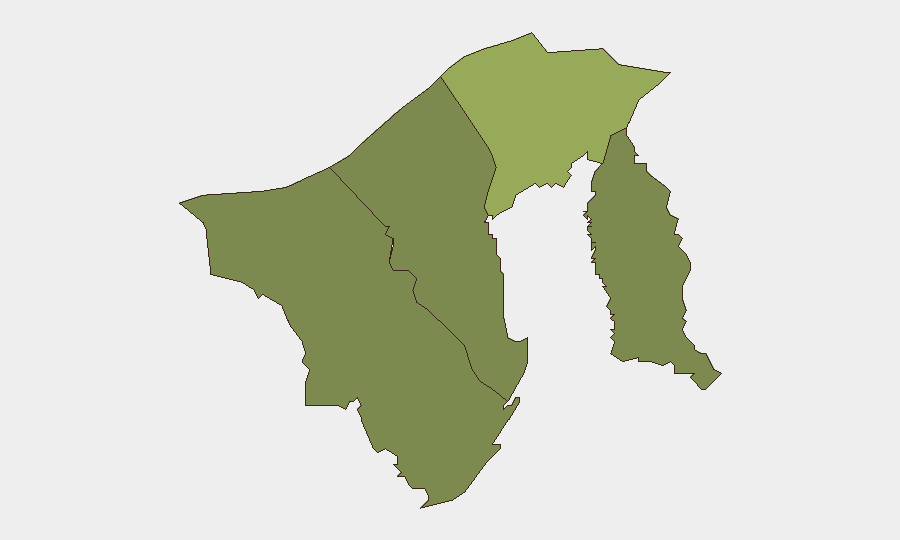
Brunei-Muara District (risk score 45) drives the majority of recorded risk and remains the focus of enforcement and incident reporting, reflecting its status as the capital and largest urban center. Tutong, Belait, and Temburong districts score significantly lower (20, 15, and 10 respectively), indicating geographically concentrated risk. The current week's primary threat—transboundary haze—is countrywide and affects all districts; however, Brunei-Muara, as the commercial and administrative hub with higher population density, experiences proportionally greater operational disruption.
How GeoBit Would Assist
Security teams would deploy AOI Monitoring & Early Warning capability to track real-time air-quality and visibility data, with automated alerting for threshold breaches affecting operations or travel. Environmental & Health intelligence and multi-source OSINT fusion enable rapid correlation of regional haze sources, wind patterns, and forecast timelines to anticipate disruption windows. Routing & Network Analysis tools support alternative route and journey planning when visibility degradation affects road and air travel safety.
7-Day Outlook
Haze conditions are forecast to persist through early September with minimal rainfall expected, maintaining visibility constraints and air-quality warnings. Routine law-enforcement activity and the bilateral military exercise will continue without material escalation. No significant security incidents are anticipated; risk remains concentrated on environmental health and operational disruption rather than security threats.
Highest-Risk Areas — Ranked
| # | State / Region | Risk |
|---|---|---|
| 1 | Brunei-Muara District | 45 |
| 2 | Tutong District | 20 |
| 3 | Belait District | 15 |
| 4 | Temburong District | 10 |
Sources
Previous Weekly Briefs
A new Brunei brief is written every Monday, covering the week — each with its own risk map and downloadable CSV. Use the calendar to go further back.
- August 31, 2026
- August 29, 2026
- August 26, 2026
- August 24, 2026
- August 22, 2026
- August 20, 2026
- August 18, 2026
📅 Browse past briefs by calendar →
Highlighted days have a brief. Tap a day for that day's map & analysis, or “csv” for that day's dataset ($5).
Atlas — our AI intelligence desk — emails them this snapshot personally. Nothing else, no list.