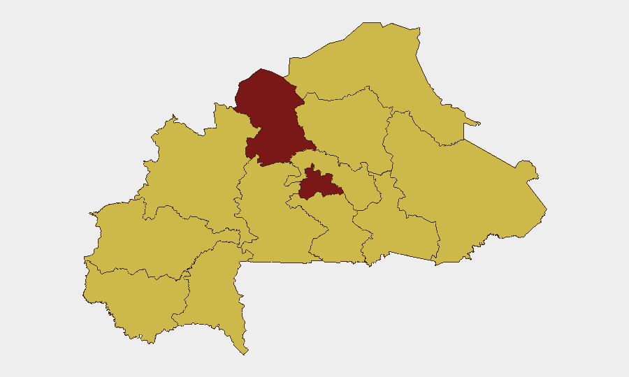
Situation Summary
Burkina Faso remains classified at global threat rank #17 (composite score 97) with persistent volatility concentrated in the North and Centre regions. The last 24–48 hours have yielded sparse incident-level reporting in open sources; available signals point to ongoing governance and judicial activity rather than new tactical security events. Baseline risk posture remains elevated across 12 sub-national zones, with the North at 97.8 composite risk—substantially above all other regions—reflecting sustained armed-group and military pressure. The security environment reflects a pattern of chronic instability rather than acute escalation at this reporting window.
Key Developments
- Ouagadougou / National (23–24 June 2026): Ongoing pressure on journalists and civic actors reported across the capital and nationwide; characterized as a human-rights concern with limited corroborating incident detail in 48-hour open-source window.
- National Judicial Sector (24 June 2026): Two arrest/detention events involving magistrate authority recorded; specific locations, facility designations, and charge details remain unconfirmed; operational significance not yet clarified by multi-source reporting.
- Multi-Border Sectors (22–23 June 2026): Modern surveillance tower installation and border-surveillance infrastructure expansion reported across frontier zones; assessed as state security posture measure rather than response to discrete incident.
- No confirmed attack/clash events (last 24–48h): Uncorroborated social-media claims of attacks on military positions around 22–23 June lack independent verification, precise location, or casualty confirmation; excluded from operational summary pending corroboration.
- Regional Statement Activity (25 June 2026): ECOWAS issued public statement regarding Burkina Faso; full text and operational implications require secondary-source review.
Note: Open newswires, African regional outlets, and verified social-media feeds have not published discrete incident reports (armed clashes, mass casualty events, infrastructure failures, or travel advisories) specifically time-bounded to the last 24–48 hours in Burkina Faso. Governance and rights-related activity is ongoing but lacks incident-level precision.
Highest-Risk Areas
The North region (risk 97.8) drives the national threat score and represents the dominant security concern, reflecting sustained armed-group operations, military engagement, and displacement pressure. The Centre region (82.8) follows as the secondary hotspot, likely driven by armed activity in peripheral zones and governance-related incidents in or near Ouagadougou. The remaining ten regions cluster at 67.8, indicating a widespread but lower-intensity security baseline across the country's periphery, with volatility stemming from cross-border infiltration, criminal activity, and intermittent military operations. North and Centre together account for the bulk of tracked recent events and represent the primary focus for duty-of-care and asset-protection planning.
How GeoBit Would Assist
Corporate security teams should deploy AOI Monitoring & Early Warning on North and Centre regions to detect emerging incidents (clashes, protests, infrastructure disruption) in near-real time. Intel Sweep combined with X/Twitter and Telegram OSINT and multi-language search enable continuous monitoring of journalist activity, judicial proceedings, and military operations without reliance on delayed newswire reporting. GIS & Spatial Analysis overlaid with border & disputed-territory search capabilities help route personnel and assets away from high-volatility zones and inform contingency-planning for cross-border staff movements.
7-Day Outlook
No discrete tactical escalation is evident in the 24–48-hour window, but baseline volatility in the North and Centre is expected to persist. Judicial and media-pressure trends suggest continued governance-related tension; monitoring for coordinated arrests, visa restrictions on international observers, or further press closures would provide early warning of internal instability. Security teams should maintain heightened readiness posture and assume no near-term de-escalation without explicit diplomatic or military developments.
Highest-Risk Areas — Ranked
| # | State / Region | Risk |
|---|---|---|
| 1 | North | 97.8 |
| 2 | Centre | 82.8 |
| 3 | Upper-Basins | 67.8 |
| 4 | Boucle du Mouhoun | 67.8 |
| 5 | Central-West | 67.8 |
| 6 | Central-South | 67.8 |
| 7 | Central-East | 67.8 |
| 8 | Waterfalls | 67.8 |
| 9 | Southwest | 67.8 |
| 10 | Sahel | 67.8 |
| 11 | Central-North | 67.8 |
| 12 | East | 67.8 |
Sources
Previous Daily Briefs
A new Burkina Faso brief is written every day — each with its own risk map and downloadable CSV. Here's the last week; use the calendar to go further back.
📅 Browse every day by calendar →
Highlighted days have a brief. Tap a day for that day's map & analysis, or “csv” for that day's dataset ($5).