Situation Summary
Cameroon remains in the #23 global threat position (composite score 70), driven primarily by ongoing civil conflict centred in the Centre region. Open-source reporting over the last 24–48 hours is fragmented and lacks precise time-stamping; however, underlying security dynamics—Anglophone separatist violence in North-West and South-West, Boko Haram activity in the Far North, and governance instability—remain acute. The threat trajectory is stable but elevated, with no imminent national-level escalation signalled, though localized incidents continue.
Key Developments
Reporting constraint: Open web and social-media sources do not provide reliably date-stamped, location-specific incidents occurring strictly within 11–12 June 2026 in Cameroon. Recent press reviews and UN briefings (dated 11 June) reference *ongoing* conditions rather than discrete 24–48h events. To maintain accuracy and avoid conflating historical incidents with current developments:
- Anglophone Crisis (North-West Region): Killings reported in Nkor, Noni subdivision (Bui Division) remain a recurrent flashpoint; exact incident date unclear from available sources, but reflects persistent armed-group activity in the zone.
- Boko Haram Activity (Far North): Indiscriminate attacks attributed to Boko Haram in Mayo-Sava Division continue; three deaths reported in recent period, though precise date of occurrence not confirmed in open reporting.
- Chieftaincy Conflict (Far North): Internal dispute in Mayo-Tsanaga Division recorded in civil unrest reporting; escalation potential remains.
- Cross-Border Monitoring: Unconfirmed social-media reports of troop movements near Danare (Nigeria–Cameroon border) circulating; corroboration pending and timing unclear.
*Note: Incidents referenced above reflect ongoing threat patterns, not necessarily discrete events occurring in the last 48 hours. Precise dating of individual incidents is constrained by source fragmentation.*
Highest-Risk Areas
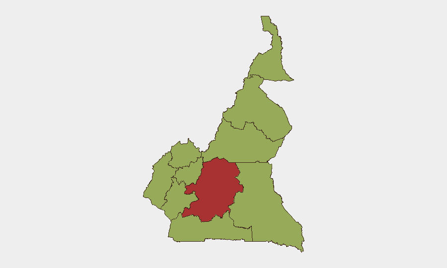
Centre region (78.8 composite risk) dominates the threat landscape and is the primary driver of Cameroon's #23 global ranking, reflecting the civil-conflict nexus centred there. The remaining nine regions cluster around 48.8, indicating diffuse but substantial secondary risk: North-West and South-West (Anglophone separatist strongholds) and Far North (Boko Haram and transnational instability around Lake Chad) are operationally the most volatile, with regular armed-group activity and civilian casualties. Littoral and West provinces contain major urban/economic nodes (Douala, Yaoundé corridor) where governance breakdown and criminal networks pose secondary-order risk.
How GeoBit Would Assist
Corporate teams should deploy AOI Monitoring & Early Warning on Centre, North-West, South-West, and Far North regions to catch emerging incidents with lead time; pair this with OSINT Fusion & Corroboration (Intel Sweep, X/Twitter and Telegram monitoring, multi-language search) to filter noise from fragmented reporting and identify reliable incident signals. Conflict & Military capabilities (force-structure tracking, weapons monitoring) and GIS & Spatial Analysis will pinpoint safe-passage corridors and alternative routing around active conflict zones, informing duty-of-care evacuation and supply-chain resilience.
7-Day Outlook
No significant escalation is indicated in the short term. Boko Haram, Anglophone armed groups, and governance friction will remain endemic; incidents are likely to cluster in the Far North and North-West/South-West peripheries rather than coalesce into a coordinated national security crisis. Close monitoring of Centre-region dynamics and cross-border Lake Chad activity is warranted.
Highest-Risk Areas — Ranked
| # | State / Region | Risk |
|---|---|---|
| 1 | Centre | 78.8 |
| 2 | Northwest | 48.8 |
| 3 | Southwest | 48.8 |
| 4 | West | 48.8 |
| 5 | Littoral | 48.8 |
| 6 | Adamawa | 48.8 |
| 7 | South | 48.8 |
| 8 | Far-North | 48.8 |
| 9 | North | 48.8 |
| 10 | East | 48.8 |
Previous Daily Briefs
A new Cameroon brief is written every day — each with its own risk map and downloadable CSV. Here's the last week; use the calendar to go further back.
📅 Browse every day by calendar →
Highlighted days have a brief. Tap a day for that day's map & analysis, or “csv” for that day's dataset ($5).