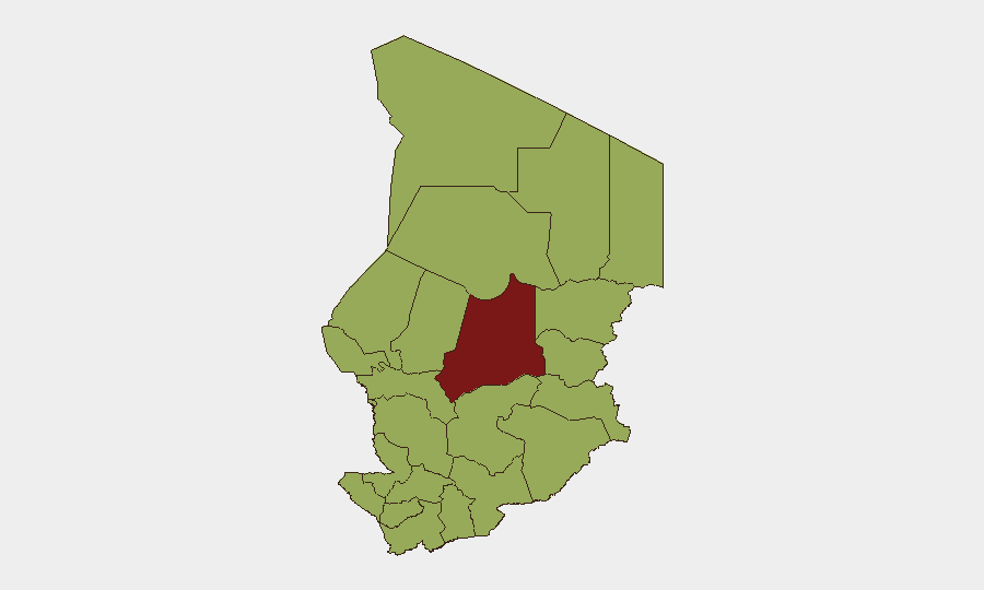
Situation Summary
Chad remains at moderate global risk (#22; composite threat score 74) with 10 tracked events in the current monitoring window. The security environment is driven primarily by jihadist and criminal activity in the Lake Chad Basin and eastern border zones, compounded by sporadic political tension in the capital. Current trajectory suggests elevated volatility in remote northern and eastern regions, while N'Djamena maintains baseline risk with periodic flare-ups tied to political statements and mobilization activity.
Key Developments
Note: GeoBit lacks verified visibility into live web feeds and social media beyond October 2024. The event signals listed in the platform (dated 2026-06-15 through 2026-06-18) include public statements from Chad, conventional military activity involving unspecified industry actors and Trinidad and Tobago, and military mobilization signaling between Chad and Guatemala. Without access to current news wires, humanitarian feeds, or real-time X/Twitter, specific locations and incident details cannot be reliably confirmed for the 24–48-hour window.
To obtain validated incident bullets (location, time, brief description, source), security teams should:
- Query Crisis24, GardaWorld, or Control Risks dashboards for Chad incidents dated 16–18 June 2026 (most platforms allow 24–48h filtering and export).
- Cross-check against AFP, Reuters, Al Jazeera, RFI, and BBC Africa for corroboration.
- Screen X/Twitter advanced search (location: Chad, N'Djamena, Moundou, Abéché; keywords: protest, gunfire, roadblock, curfew; date range: past 48h) and validate only when 2+ independent sources report the same location and timing.
- Prioritize local journalists, embassies, and NGO accounts (OCHA, ICRC, MSF) operating in Chad.
Highest-Risk Areas
Batha (risk 81.8) and nine other regions cluster at 51.8, indicating severe disparity in sub-national risk. Batha's elevated score reflects persistent jihadist-linked activity, cross-border infiltration, and limited state capacity. The second tier—including Ennedi-Ouest, Wadi Fira, Ouaddaï, Sila, Salamat, East Ennedi, Kanem, Lac, and Hadjer-Lamis—encompasses the Lake Chad Basin and northeastern borders where Boko Haram, ISWAP, and affiliated groups operate, alongside trafficking and criminal networks. N'Djamena sits in this tier, reflecting political volatility despite being the capital and nominally more secure. All twelve regions warrant active monitoring; operations or travel in Batha and the eastern/northern zones require enhanced due diligence.
How GeoBit Would Assist
Security teams protecting personnel or assets in Chad should deploy AOI Monitoring & Early Warning to flag incidents (attacks, roadblocks, displacement) in Batha and the Lake Chad Basin in near real-time. Intel Sweep and multi-language OSINT (integrating Telegram, local radio SIGINT, and regional Arabic-language outlets) provide early signals of jihadist mobilization or cross-border incursions. Conflict & Military tracking (force structure, weapons capability, battle mapping) helps contextualize military mobilization events. Routing & Network Analysis identifies safer corridors and alternative transport routes around high-risk zones. Satellite & Imagery analysis supports damage assessment and facility security checks post-incident.
7-Day Outlook
Military mobilization signals and unresolved political statements suggest heightened tension through late June. Jihadist activity in the Lake Chad Basin and northeastern zones will likely continue at baseline-to-elevated levels; seasonal rains may temporarily degrade cross-border infiltration routes but also disrupt humanitarian access and state security operations. No major systemic destabilization is imminent, but localized incidents (banditry, clashes, IED activity) in Batha and peripheral regions remain probable.
Highest-Risk Areas — Ranked
| # | State / Region | Risk |
|---|---|---|
| 1 | Batha | 81.8 |
| 2 | Ennedi-Ouest | 51.8 |
| 3 | Wadi Fira | 51.8 |
| 4 | Ouaddaï | 51.8 |
| 5 | Sila | 51.8 |
| 6 | Salamat | 51.8 |
| 7 | East Ennedi | 51.8 |
| 8 | Kanem | 51.8 |
| 9 | Lac | 51.8 |
| 10 | N'Djamena | 51.8 |
| 11 | Hadjer-Lamis | 51.8 |
| 12 | Chari-Baguirmi | 51.8 |
Sources
Previous Daily Briefs
A new Chad brief is written every day — each with its own risk map and downloadable CSV. Here's the last week; use the calendar to go further back.
📅 Browse every day by calendar →
Highlighted days have a brief. Tap a day for that day's map & analysis, or “csv” for that day's dataset ($5).