Situation Summary
Chad remains a composite threat level #29 globally (score 67/100), with persistent instability concentrated in the northeast and north-central regions. The country faces overlapping pressures from Sudanese refugee flows, transnational militant activity, and reported weapons transits linked to Sudan's conflict. No major discrete security incidents have been reported in the last 24–48 hours within Chad's borders; however, underlying structural vulnerabilities—particularly in Batha region—remain acute and warrant continuous monitoring.
Key Developments
24–48 Hour Window: Open-source reporting does not confirm new, clearly datable incident-level events within Chad territory for 2026-06-18 to 2026-06-19 meeting multi-source confirmation standards. The GeoBit event stream reflects diplomatic/administrative actions (statements, arrests linked to U.S./international actors, military mobilization language toward Guatemala) rather than localized security incidents in Chad itself.
Near-Border Context (June 18, 2026): Critical Threats Project reporting indicates that Emirati-linked aircraft continue to land at multiple Chadian airports for onward weapons transit to Sudan's RSF; this represents ongoing logistical risk but not a discrete dated incident. This activity underscores Chad's role as a transit corridor and potential flashpoint for unintended escalation.
Humanitarian Development (June 17, 2026): Doctors Without Borders announced dismissal of 18 staff members following investigation into sexual exploitation and abuse of Sudanese refugee women and girls in Chad; 59 alleged cases documented. While the disclosure is current, the incidents span an earlier period; this reflects governance risk within humanitarian operations rather than a new security event.
Hepatitis E Alert: A recent disease event flagged in GeoBit signals warrants public-health inclusion in duty-of-care briefings, particularly for Sudanese refugee populations and humanitarian workers.
Highest-Risk Areas
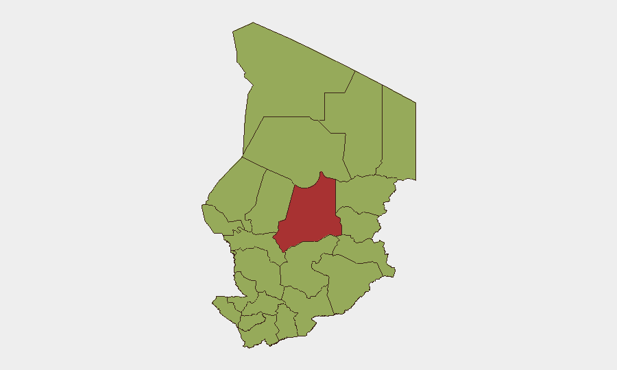
Batha region (risk 77) dominates the threat landscape, driven by militant activity, cross-border trafficking, and weak state presence. N'Djamena (51.3) registers elevated risk due to capital-city concentration of political actors, diplomatic friction, and petty crime affecting expat/business communities. The remaining ten tracked regions cluster at risk 47, reflecting diffuse instability across the Sahel periphery—Lac, Kanem, Hadjer-Lamis, and Ennedi zones are migration corridors and ungoverned spaces exploited by armed groups. Wadi Fira and Ouaddaï pose secondary but significant risk from militant infiltration and resource scarcity.
How GeoBit Would Assist
Area-of-Interest (AOI) Monitoring & Early Warning with persistent alerting on Batha, N'Djamena, and border zones would flag escalation before it reaches crisis scale. Routing & Network Analysis supports security teams planning alternative routes for personnel and supply convoys away from high-risk corridors. Conflict & Military capability—including force-structure tracking and border/disputed-territory search—enables assessment of militant group posture and Chadian Armed Forces disposition, informing evacuation and asset-protection protocols.
7-Day Outlook
Short-term escalation risk remains low to moderate, absent new diplomatic ruptures or border incursions. However, the ongoing weapons-transit activity through Chadian airspace and continued refugee influx from Sudan sustain cumulative pressure on state capacity and create conditions for opportunistic militant expansion or criminal activity. Security teams should maintain heightened vigilance in Batha and maintain current communication protocols with host-nation authorities and NGO partners.
Highest-Risk Areas — Ranked
| # | State / Region | Risk |
|---|---|---|
| 1 | Batha | 77 |
| 2 | N'Djamena | 51.3 |
| 3 | Ennedi-Ouest | 47 |
| 4 | Wadi Fira | 47 |
| 5 | Ouaddaï | 47 |
| 6 | Sila | 47 |
| 7 | Salamat | 47 |
| 8 | East Ennedi | 47 |
| 9 | Kanem | 47 |
| 10 | Lac | 47 |
| 11 | Hadjer-Lamis | 47 |
| 12 | Chari-Baguirmi | 47 |
Sources
Previous Daily Briefs
A new Chad brief is written every day — each with its own risk map and downloadable CSV. Here's the last week; use the calendar to go further back.
📅 Browse every day by calendar →
Highlighted days have a brief. Tap a day for that day's map & analysis, or “csv” for that day's dataset ($5).