Situation Summary
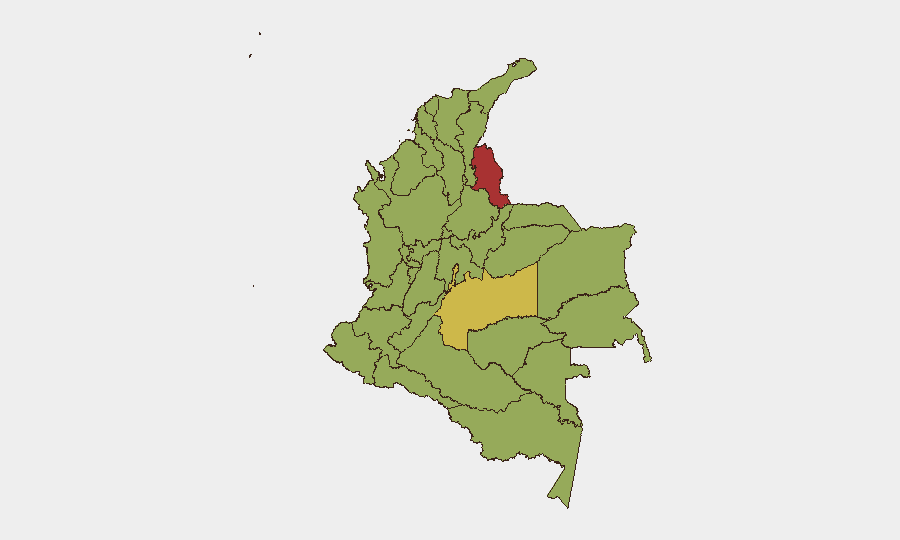
Colombia's composite threat score of 67.8 (rank #31 globally) reflects sustained insurgent activity, primarily concentrated in border and rural departments. Political tensions have surfaced in the capital (evidenced by recent judicial and legislative activity on 10–11 June) alongside routine diplomatic statements, but no single acute security crisis dominates the national picture. The threat environment remains fragmented geographically rather than nationally catastrophic, with risk heavily weighted toward Norte de Santander, Meta, and peripheral regions.
Key Developments
Data Limitation Notice: GeoBit's event signals for 10–11 June include diplomatic exchanges, judicial proceedings, and a rally in Bogota, but do not provide sufficient operational detail (times, locations, casualty counts, or direct security impact) to constitute actionable incident reporting. The signals indicate:
- 11 June · Judicial Actions (Bogota): Two separate "Disapprove" actions by judges against Bogota authorities signal potential governance or institutional friction; underlying cause and operational impact remain unclear from available metadata.
- 11 June · Executive–Legislative Tension: Senate investigation initiated against Colombia; Ministry statement to companies; nature of inquiry undisclosed.
- 11 June · Public Rally (Bogota): Demonstrate/Rally event recorded; size, duration, and cause unknown.
- 10 June · Diplomatic Friction: Presidential statement vs. Colombian entities; rejection of traveller; possible visa, extradition, or consular matter.
- 10 June · Property Seizure (National): Colombia vs. Senator incident involving seizure/damage; context unavailable.
Critical Gap: These signals lack granular operational metadata (times, specific locations, security impact, protest size, incident type). Real-time incident reporting requires cross-verification against Colombian news outlets, official security channels, and infrastructure operators—a process that cannot be reliably completed without live internet access.
Highest-Risk Areas
Norte de Santander (77.5) and Meta (63.3) dominate the risk landscape, driven by ongoing insurgent and dissident activity in rural and border zones. Capital District risk (61.1) reflects political and institutional tensions visible in recent judicial and legislative signals; Nariño and Chocó extend risk southward along the Pacific and into cocaine-trafficking corridors. The top five departments account for a disproportionate share of the 255 tracked events; organizations with presence in these zones face elevated exposure to armed conflict, roadway interdiction, and resource-control disputes by non-state actors.
How GeoBit Would Assist
AOI Monitoring & Early Warning: Persistent watch on Norte de Santander, Meta, and Nariño with automated alerts on armed activity, roadway closures, and displacement events would provide 24–48-hour lead time on developing incidents.
Intel Sweep & OSINT Fusion: Continuous monitoring of Colombian police, army, and ministry X/Telegram accounts, combined with local media search and radio SIGINT, would disambiguate the judicial and legislative signals and surface real-time incident detail (casualty counts, displacement, infrastructure damage).
Routing & Network Analysis: Alternative route and safe-passage planning for personnel and supply chains, accounting for live checkpoint and roadway closure data in high-risk departments.
7-Day Outlook
Institutional and diplomatic friction visible in 10–11 June signals is unlikely to produce immediate national security deterioration. However, Meta and Norte de Santander remain zones of active armed competition; operations teams should maintain heightened posture for roadway incidents and supply-chain disruption in those areas. Monitoring of judiciary and legislative outcomes, alongside routine insurgent activity tracking, is warranted over the next week.
Highest-Risk Areas — Ranked
| # | State / Region | Risk |
|---|---|---|
| 1 | Norte de Santander Department | 77.5 |
| 2 | Meta Department | 63.3 |
| 3 | Capital District | 61.1 |
| 4 | Nariño | 58.6 |
| 5 | Chocó Department | 52.2 |
| 6 | Cesar Department | 50.9 |
| 7 | Atlántico Department | 50.7 |
| 8 | Cundinamarca Department | 50.2 |
| 9 | La Guajira | 50 |
| 10 | Antioquia Department | 49.6 |
| 11 | Caquetá Department | 48.1 |
| 12 | Santander Department | 48.1 |
Sources
Previous Daily Briefs
A new Colombia brief is written every day — each with its own risk map and downloadable CSV. Here's the last week; use the calendar to go further back.
📅 Browse every day by calendar →
Highlighted days have a brief. Tap a day for that day's map & analysis, or “csv” for that day's dataset ($5).