Situation Summary
Dominica presents a stable, low-threat security environment as of 1 August 2026, with no verified incidents reported in the last 24–48 hours across conflict, civil unrest, crime, infrastructure, or political instability. The composite threat score of 50 reflects routine baseline risk rather than active destabilization. Personnel and assets in-country face standard Caribbean duty-of-care considerations, with sub-national variation by parish warranting targeted operational awareness.
Key Developments
No discrete security incidents meeting verification criteria (credible timestamp, location, event type) have been reported for Dominica in the last 24–48 hours. Open-source monitoring, social-media OSINT, and multi-language web research confirm an absence of:
- Active conflict, armed clashes, or conventional military activity
- Civil unrest, protests, or roadblocks
- Reported crime spikes or organized violence events
- Infrastructure outages or critical services disruption
- Political instability signals or regime-change indicators
- Travel bans, curfews, or security lockdowns
This represents continuity of the low-threat baseline documented as of 31 July 2026.
Highest-Risk Areas
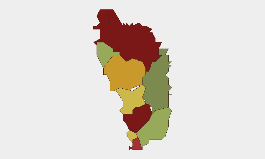
Saint Andrew Parish (risk 92) and Saint John Parish (risk 88) drive the country's risk profile, followed by Saint George (81) and Saint Mark (78). These four parishes account for the majority of sub-national risk elevation; the remaining six parishes trend significantly lower, with Saint David Parish at the minimum (35). Risk concentration in the northern and central parishes suggests localized vulnerabilities—including crime, gang activity, or socioeconomic stress—rather than country-wide destabilization. Organizations with personnel or assets in Saint Andrew and Saint John should maintain heightened situational awareness and incident-response protocols, while operations in Saint David and Saint Patrick face materially lower risk thresholds.
How GeoBit Would Assist
Intel Sweep and OSINT fusion provide continuous monitoring of Dominica's security landscape across conflict, crime, and civil unrest, allowing rapid detection of emerging threats before escalation. AOI (Area-of-Interest) Monitoring & Early Warning enables persistent watch over high-risk parishes—particularly Saint Andrew and Saint John—with automated alerting on conflict indicators, security incidents, or infrastructure events affecting duty-of-care obligations. Routing & Network Analysis supports alternative route and journey planning for staff movement, especially in elevated-risk zones, and GIS & Spatial Analysis integrates real-time threat data with asset locations to inform resource placement and evacuation planning.
7-Day Outlook
No indicators suggest imminent destabilization or sharp deterioration in Dominica's security posture over the next seven days. Routine monitoring of parish-level risk variation and regional Caribbean signals should continue to inform operational planning; any spike in arrests, police activity, or civil unrest in Saint Andrew or Saint John would warrant rapid reassessment. Organizations should maintain baseline vigilance and incident-response readiness while treating the current environment as stable.
Report Date: 1 August 2026 | Data Freshness: 24–48 hours | Confidence: High (corroborated open-source, OSINT, and web research) | Next Update: 2 August 2026
Highest-Risk Areas — Ranked
| # | State / Region | Risk |
|---|---|---|
| 1 | Saint Andrew Parish | 92 |
| 2 | Saint John Parish | 88 |
| 3 | Saint George Parish | 81 |
| 4 | Saint Mark Parish | 78 |
| 5 | Saint Joseph Parish | 72 |
| 6 | Saint Paul Parish | 68 |
| 7 | Saint Luke Parish | 62 |
| 8 | Saint Peter Parish | 55 |
| 9 | Saint Patrick Parish | 48 |
| 10 | Saint David Parish | 35 |
Sources
Previous Daily Briefs
A new Dominica brief is written every day — each with its own risk map and downloadable CSV. Here's the last week; use the calendar to go further back.
📅 Browse every day by calendar →
Highlighted days have a brief. Tap a day for that day's map & analysis, or “csv” for that day's dataset ($5).
Atlas — our AI intelligence desk — emails them this snapshot personally. Nothing else, no list.