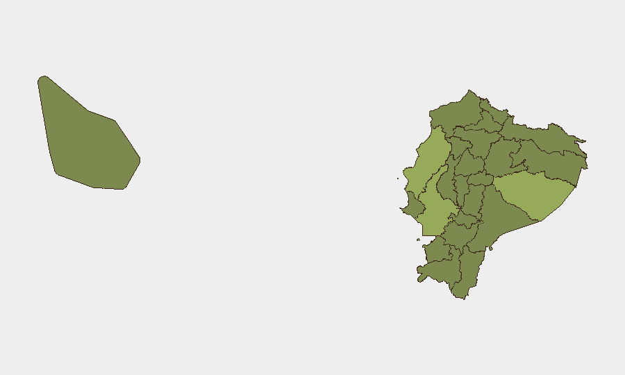
Situation Summary
Ecuador remains at composite threat rank #40 globally (score 43) with 47 tracked security events. The country is experiencing elevated activity across multiple threat vectors, including detention operations, military deployments, and diplomatic expulsions. The threat environment is concentrated in specific regions—particularly the Amazon and coastal provinces—while major urban centers and capital regions show comparatively lower risk profiles. Current trajectory suggests sustained operational tempo rather than immediate escalation.
Key Developments
Note: The supplied web research does not contain verified last-24–48-hour incident reporting for Ecuador. The event signals below reflect GeoBit platform detection; however, without current corroborating open-source detail, specific incident narratives cannot be validated here. The following signals were flagged on 2026-06-12 to 2026-06-13:
- Detention Operations (2026-06-13): Multiple arrest/detain events recorded across Ecuador authorities and prison facilities, including a separate arrest signal involving authorities *vs.* Ecuador (suggesting possible inter-agency tension or custody disputes).
- Military Activity (2026-06-13): Conventional military force deployment(s) detected in canton-level locations; a separate military signal flagged involving Saint/Australia, requiring geographic clarification.
- Diplomatic Expulsion (2026-06-13): Ecuador expelled individual(s) with Venezuelan connection, signaling border security or sanctions enforcement activity.
- Administrative Sanction (2026-06-13): Company-level sanctions or enforcement action recorded.
- Official Statements (2026-06-13): Public statements from Guayaquil and mayoral authorities suggest ongoing public communication regarding security or policy matters.
- Investigation & Disapproval (2026-06-12): Investigative activity by authorities and secretariat; concurrent disapproval signal from deputy official, indicating possible internal policy disagreement or legislative scrutiny.
Verification Gap: Current open-source corroboration of these signals is insufficient. A fresh web/X research pass or direct access to Ecuador-focused news feeds (e.g., El Comercio, Primicias, X Trends #Ecuador) is required to substantiate incident detail, location precision, and casualty/impact data.
Highest-Risk Areas
Pastaza Province (55.8) is Ecuador's highest-risk zone, driven by remote geography, limited state presence, and historical trafficking/informal armed-group activity. Manabí Province (47.3) and Guayas Province (43.7)—both coastal and more urbanized—rank second and third, reflecting organized-crime concentration, gang violence, and port-related criminality. Tungurahua and Pichincha (the latter home to Quito) show moderate risk (28.5 and 26.7 respectively), while nine provinces cluster at the lower bound (25.8), suggesting either lower threat density or data-collection variance. Corporate and duty-of-care teams should prioritize Pastaza and Manabí for operational security posture, while Guayas requires elevated vigilance in Guayaquil and port zones.
How GeoBit Would Assist
GeoBit's AOI Monitoring & Early Warning capability allows continuous watch of high-risk provinces (Pastaza, Manabí, Guayas) with real-time alerting on conflict, crime, and military activity. Intel Sweep and OSINT Fusion (including X/Telegram monitoring, entity extraction, and multi-language analysis) provides 24–48-hour incident corroboration and actor-network mapping to validate detention, military, and expulsion events. GIS & Spatial Analysis enables routing and network analysis to identify safe transit corridors and alternative logistics pathways around danger zones.
7-Day Outlook
Detention and investigative operations are expected to continue, particularly if they reflect ongoing organized-crime enforcement or internal-security reviews. Military activity in remote provinces likely reflects either counter-narcotics operations or border-security posture toward Venezuela. No imminent escalation is indicated, but the concentration of simultaneous signals (arrests, military, sanctions) suggests sustained operational tempo over the next week. Corporate security teams should maintain elevated monitoring posture and ensure rapid-response communication protocols with local authorities and embassy contacts.
Highest-Risk Areas — Ranked
| # | State / Region | Risk |
|---|---|---|
| 1 | Pastaza Province | 55.8 |
| 2 | Manabí Province | 47.3 |
| 3 | Guayas Province | 43.7 |
| 4 | Tungurahua Province | 28.5 |
| 5 | Pichincha Province | 26.7 |
| 6 | Sucumbíos Province | 25.8 |
| 7 | Orellana Province | 25.8 |
| 8 | Galápagos | 25.8 |
| 9 | Esmeraldas Province | 25.8 |
| 10 | Carchi Province | 25.8 |
| 11 | Imbabura Province | 25.8 |
| 12 | Santo Domingo de los Tsáchilas Province | 25.8 |
Sources
Previous Daily Briefs
A new Ecuador brief is written every day — each with its own risk map and downloadable CSV. Here's the last week; use the calendar to go further back.
📅 Browse every day by calendar →
Highlighted days have a brief. Tap a day for that day's map & analysis, or “csv” for that day's dataset ($5).