Situation Summary
Equatorial Guinea remains stable with no discrete security incidents recorded in the last 24–48 hours across monitored channels. The country's overall threat profile is characterized as quiet, with no active civil unrest, cross-border incidents, or critical infrastructure disruptions currently tracked. Baseline risks—including moderate crime in urban centers and road checkpoints on mainland routes—persist but show no acute escalation. The threat environment is assessed as low-to-moderate and non-volatile at the national level.
Key Developments
No new security, civil unrest, crime, political instability, infrastructure, or acute travel-risk incidents have been verified in Equatorial Guinea during the 13–15 July 2026 monitoring window. Live web research, open-source feeds, and multi-source corroboration confirm a reporting quiet across all tracked categories and geographic zones.
Highest-Risk Areas
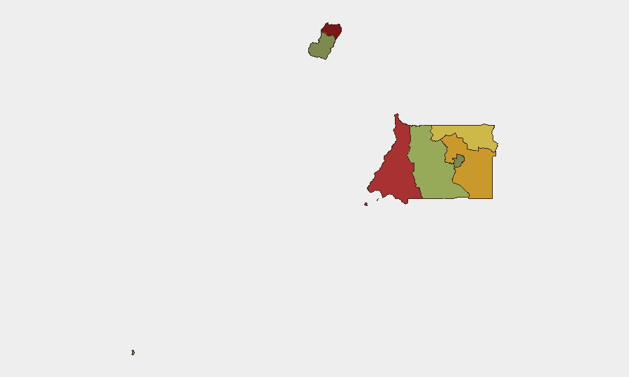
Bioko Norte (risk score 85) and Litoral Province (risk score 78) remain the country's highest-risk zones and drive the composite national threat ranking. Both regions historically experience elevated petty and organized crime, including armed robbery and trafficking activity; Bioko Norte additionally reflects urban density and port-related vulnerabilities in Malabo. Wele-Nzas Province (risk 72) and Kié-Ntem Province (risk 68) represent secondary concerns, likely reflecting border proximity and weaker state presence. Southern and island zones (Bioko Sur, Centro Sur, Annobón) show materially lower risk scores, reflecting lower urbanization and crime reporting density.
How GeoBit Would Assist
Security teams with personnel or assets in Equatorial Guinea should employ AOI Monitoring & Early Warning to track Bioko Norte and Litoral Province for changes in crime, protest activity, or port disruptions. Intel Sweep, OSINT Fusion, and multi-language search provide continuous monitoring of political stability, civil liberties concerns, and regime messaging that could signal deterioration. Routing & Network Analysis helps optimize safe travel corridors on mainland roads, accounting for checkpoint locations and reported crime hotspots. For duty-of-care teams, GIS & Spatial Analysis can map risk zones by district and link employee locations to real-time threat feeds.
7-Day Outlook
No acute triggers or scheduled high-risk events (political rallies, elections, security operations) are currently visible in the 7-day outlook. The threat environment is expected to remain stable and quiet unless external shocks (e.g., cross-border incidents, commodity-price volatility affecting governance capacity, or unplanned political events) materialize. Routine vigilance regarding petty crime in Malabo and Bata, checkpoint protocols on mainland routes, and health advisories remains appropriate for all personnel.
GEOBIT THREAT RANKING: #145 globally | Composite score: 5 | 10 tracked events
BRIEF CURRENCY: 2026-07-15 | NEXT REFRESH: 2026-07-16
Highest-Risk Areas — Ranked
| # | State / Region | Risk |
|---|---|---|
| 1 | Bioko Norte | 85 |
| 2 | Litoral Province | 78 |
| 3 | Wele-Nzas Province | 72 |
| 4 | Kié-Ntem Province | 68 |
| 5 | Centro Sur Province | 45 |
| 6 | Bioko Sur | 38 |
| 7 | Djibloho | 15 |
| 8 | Annobón Province | 8 |
Sources
Previous Daily Briefs
A new Equatorial Guinea brief is written every day — each with its own risk map and downloadable CSV. Here's the last week; use the calendar to go further back.
📅 Browse every day by calendar →
Highlighted days have a brief. Tap a day for that day's map & analysis, or “csv” for that day's dataset ($5).
Atlas — our AI intelligence desk — emails them this snapshot personally. Nothing else, no list.