Situation Summary
Eritrea remains a low-frequency threat environment (global rank #136, composite score 6) with no corroborated security incidents reported in the last 24–48 hours. The threat landscape is geographically concentrated in the western and southern border regions, where historical tensions, illicit movement, and limited state control create persistent baseline risk. The security posture appears stable at the national level, though localized vulnerabilities in peripheral zones warrant continuous monitoring for early warning signals.
Key Developments
No new, corroborated incidents meeting recency and specificity criteria were identified in the last 24–48 hours (July 9–11, 2026). Web research and OSINT sources yielded no dated reports of fresh protests, clashes, attacks, infrastructure disruption, or acute travel-risk events inside Eritrea during this window. Older references to security-service roundups and civilian raids exist in the available material but lack clear timestamps placing them within July 9–11 and cannot be verified as discrete, current events. Regional developments (e.g., neighboring Sudan and Somalia situations, Eritrean refugee flows into Ethiopia) are documented but fall outside the scope of in-country Eritrea security incidents.
Highest-Risk Areas
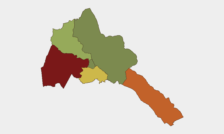
Gash-Barka (risk 92) and Southern Red Sea Region (risk 75) dominate the threat profile and account for the majority of composite risk in Eritrea. Gash-Barka's elevated score reflects its position as a porous, sparsely governed western frontier with historical cross-border movement, pastoral conflict dynamics, and limited security-force presence. The Southern Red Sea Region similarly carries maritime and smuggling vectors, combined with remote coastal and inland terrain where state authority is attenuated. By contrast, Maekel Region (risk 18)—which includes the capital, Asmara—and the Northern Red Sea Region (risk 0) show substantially lower threat indices, indicating that security apparatus presence and urban governance correlate with reduced incident frequency. Organizations with personnel or assets should prioritize awareness of western and southern corridor access routes and regulatory compliance.
How GeoBit Would Assist
Area-of-Interest (AOI) Monitoring & Early Warning on Gash-Barka and Southern Red Sea Region borders would enable persistent watch for cross-border movement, illicit activity, or localized unrest before escalation. Intel Sweep, OSINT Fusion & Corroboration, and multi-language web/social OSINT would systematize real-time detection of new incidents, protest signals, or regime-response activity across Eritrea, filtering noise from verified events. Routing & Network Analysis would allow security teams to plan alternative logistics and personnel movement routes that avoid high-risk corridors and maintain supply-chain continuity. Satellite and imagery analysis can supplement persistent monitoring of remote areas where traditional reporting is sparse.
7-Day Outlook
No acute escalation triggers are evident over the near term. Baseline risk in border zones will remain elevated; localized tensions tied to pastoral resources, cross-border smuggling, or community-level disputes may surface episodically but are unlikely to generate nationwide unrest or international incident. Duty-of-care teams should maintain routine AOI monitoring and contingency protocols while treating Eritrea as a lower-priority threat relative to regional peers.
Highest-Risk Areas — Ranked
| # | State / Region | Risk |
|---|---|---|
| 1 | Gash-Barka | 92 |
| 2 | Southern Red Sea Region | 75 |
| 3 | Debub Region | 68 |
| 4 | Anseba | 55 |
| 5 | Maekel Region | 18 |
| 6 | Northen Red Sea Region | 0 |
Sources
Previous Daily Briefs
A new Eritrea brief is written every day — each with its own risk map and downloadable CSV. Here's the last week; use the calendar to go further back.
📅 Browse every day by calendar →
Highlighted days have a brief. Tap a day for that day's map & analysis, or “csv” for that day's dataset ($5).
Atlas — our AI intelligence desk — emails them this snapshot personally. Nothing else, no list.