Situation Summary
Eswatini presents a stable near-term security environment with no confirmed acute incidents reported in the past 24–48 hours across civil unrest, conflict, major crime, infrastructure disruption, or travel impediments. The 2026 Global Peace Index reflects marginal change and no active deterioration in the domestic security environment over the past 12 months. Underlying structural vulnerabilities—including baseline crime, emergency-response constraints, and political tensions—persist but have not triggered immediate operational disruption to corporate activity or movement within the country.
Key Developments
- Nationwide (Eswatini), 27–28 July 2026: Open-source monitoring confirms absence of credible, location-specific security incidents (protests, roadblocks, violence, infrastructure failure) across news, social media, and civil-society feeds. Situation characterized as stable with no acute incident trajectory.
- Cross-border narcotics interdiction (North West Province, South Africa), 23 July 2026: South African authorities arrested two Eswatini nationals with 13 bags of dagga on the N12 near Klerksdorp. Incident occurs in South Africa, not Eswatini territory; no follow-on security incidents or destabilization reported within Eswatini in subsequent reporting window.
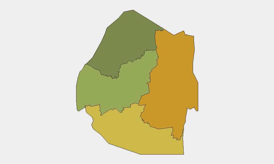
- Lubombo and Shiselweni regions (Eswatini), status as of late July 2026: Elevated baseline risk noted in these regions (crime, emergency-response limitations, political tensions), but no new discrete incidents confirmed in the last 24–48 hours; structural vulnerabilities persist without acute trigger.
Highest-Risk Areas
Lubombo (composite risk 72) and Shiselweni (risk 68) carry elevated baseline risk profiles significantly above Manzini Region (55) and Hhohho Region (35). These southern and eastern regions are characterized by higher rates of property and violent crime, constrained emergency-response infrastructure, and lingering political-community sensitivities. Crime and limited state capacity, rather than acute civil unrest or conflict, drive the risk differential. Corporate operations and personnel in these regions warrant heightened situational awareness and asset-protection protocols, though the risk remains chronic rather than acute at present.
How GeoBit Would Assist
Security teams with personnel or assets in Eswatini should employ AOI Monitoring & Early Warning to maintain persistent watch on Lubombo and Shiselweni, with alerting configured for protest activity, roadblocks, or crime-cluster signals. Intel Sweep and multi-language OSINT (including X/Twitter and local media feeds) provide continuous 24–48-hour updates on civil disturbance, political announcements, and cross-border crime that could affect duty-of-care obligations. Routing & Network Analysis assists in pre-positioning alternative travel routes and safe corridors in higher-risk regions, and GIS & Spatial Analysis can map crime patterns and incident density to inform site-security and personnel-movement decisions.
7-Day Outlook
No indicators suggest imminent escalation in civil unrest, political crisis, or major crime events within the next seven days. Baseline security posture and structural risk factors are expected to remain stable and chronic. Security teams should maintain standard monitoring and alert thresholds; travel and operations may proceed under existing protocols, with elevated caution in Lubombo and Shiselweni.
Highest-Risk Areas — Ranked
| # | State / Region | Risk |
|---|---|---|
| 1 | Lubombo | 72 |
| 2 | Shiselweni | 68 |
| 3 | Manzini Region | 55 |
| 4 | Hhohho Region | 35 |
Sources
Previous Daily Briefs
A new Eswatini brief is written every day — each with its own risk map and downloadable CSV. Here's the last week; use the calendar to go further back.
📅 Browse every day by calendar →
Highlighted days have a brief. Tap a day for that day's map & analysis, or “csv” for that day's dataset ($5).
Atlas — our AI intelligence desk — emails them this snapshot personally. Nothing else, no list.