Situation Summary
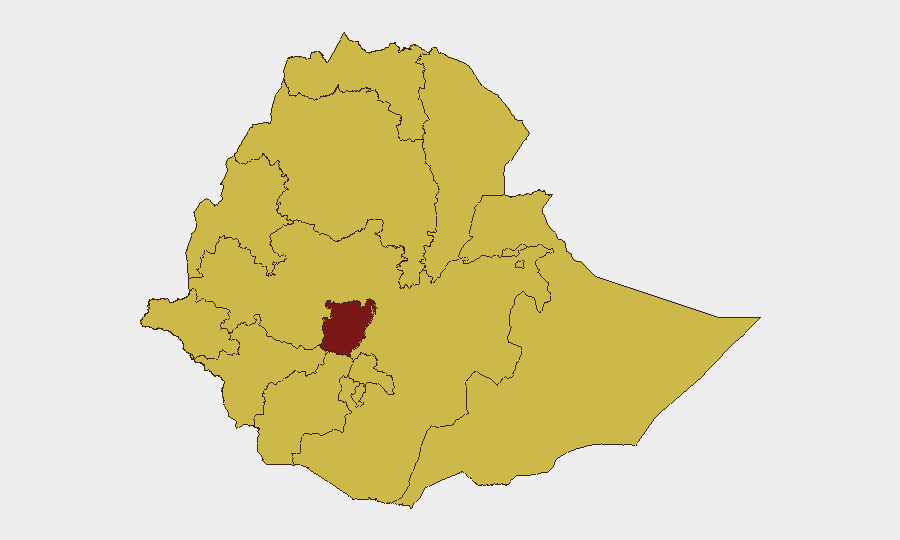
Ethiopia remains in a state of protracted civil conflict with a composite threat ranking of #9 globally, driven primarily by competing armed factions and state fragmentation across multiple regions. Recent signals indicate elevated arrest and detention activity (2026-06-15), concurrent with international investigations by Nigerian and Lagos authorities—suggesting either transnational criminal or security cooperation dimensions. Concurrent disease alerts (Marburg virus, malaria) compound humanitarian and population health risks. The security environment remains volatile and regionally uneven, with Central Ethiopia Regional State rated at critical risk (100) and ten additional regions at elevated risk (70).
Key Developments
- 2026-06-15 · Arrest/Detention Activity (nationwide). Multiple concurrent arrest and detention events logged across Ethiopia involving both operative and community actors on a single date. No specific location or underlying cause yet confirmed in available reporting; investigation ongoing to determine if these represent security sweeps, counter-terrorism operations, or other enforcement actions.
- 2026-06-15 · International Investigation (Lagos/Nigeria vs. Ethiopia). Nigerian and Lagos authorities initiated investigations involving Ethiopian persons or entities. Nature and jurisdiction unclear from current signals; may indicate transnational financial crime, human trafficking, weapons smuggling, or diplomatic/security cooperation. Requires follow-up via diplomatic channels and financial-crime intelligence.
- Recent · Disease Alert (Marburg Virus, Ethiopia). Two separate Marburg virus disease notifications registered in Ethiopia's recent event stream. Geographic scope, case count, and containment status not yet specified. Marburg carries ~50% case fatality rate and poses secondary security risks (treatment facility access, population displacement, export of cases).
- Recent · Malaria Alert (Ethiopia). Malaria activity recorded across Ethiopia; prevalence expected in lower-altitude, wetter zones (Gambela, Afar, southern Oromia, parts of Somali). No outbreak declaration noted, but endemic presence complicates medical support for staff in field operations.
Highest-Risk Areas
Central Ethiopia Regional State dominates the risk landscape (composite score 100), likely reflecting concentration of armed-group activity, state security operations, or both. Nine additional regions—including Tigray, Amhara, Afar, Benishangul-Gumuz, Somali, Gambela, South West Ethiopia Peoples, and Oromia—share elevated risk scores (70), indicating either active conflict zones, state-control instability, or criminal activity corridors. Addis Ababa itself is rated at risk level 70, suggesting that capital-city operations cannot be assumed safe; kidnapping, political detention, and indirect fire remain credible hazards. Organizations with staff or assets in these zones should treat them as high-consequence environments requiring continuous threat monitoring and contingency planning.
How GeoBit Would Assist
AOI Monitoring & Early Warning would establish persistent watch over critical business locations (offices, warehouses, residences) in Addis Ababa and regional hubs, with automated alerting on nearby security events (clashes, checkpoints, armed deployments). OSINT Fusion & Corroboration (via X/Twitter, Telegram, local media, and radio SIGINT) would cross-check arrest waves and investigative activity in real time, clarifying intent and scale. Routing & Network Analysis would generate alternative transportation and supply-chain routes to bypass active conflict zones and security cordons, critical for staff movement and logistics continuity.
7-Day Outlook
Arrest and detention activity is likely to persist or escalate as competing factions consolidate control and state security forces intensify operations. Disease outbreaks (Marburg, malaria) may drive internal displacement and restrict access to certain zones. No near-term ceasefire or de-escalation signals are evident; organizations should assume current operational constraints will hold and plan for potential deterioration in Central Ethiopia and border regions.
Highest-Risk Areas — Ranked
| # | State / Region | Risk |
|---|---|---|
| 1 | Central Ethiopia Regional State | 100 |
| 2 | Tigray | 70 |
| 3 | Amhara Region | 70 |
| 4 | Afar Region | 70 |
| 5 | Benishangul-Gumuz Region | 70 |
| 6 | Somali Region | 70 |
| 7 | Gambela Region | 70 |
| 8 | South West Ethiopia Peoples | 70 |
| 9 | Addis Ababa | 70 |
| 10 | South Ethiopia Regional State | 70 |
| 11 | Oromia Region | 70 |
| 12 | Sidama | 70 |
Sources
Previous Daily Briefs
A new Ethiopia brief is written every day — each with its own risk map and downloadable CSV. Here's the last week; use the calendar to go further back.
📅 Browse every day by calendar →
Highlighted days have a brief. Tap a day for that day's map & analysis, or “csv” for that day's dataset ($5).