Situation Summary
Guinea-Bissau remains stable in the immediate 24–48 hour window, with no reportable incidents of armed conflict, civil unrest, major crime, or infrastructure disruption. The country is operating within the context of an ongoing military-led political transition initiated in early 2024, but that transition has not generated acute security events in the last two days. Risk remains concentrated in the northern and eastern regions (Gabu, Oio, Bafatá), where cross-border dynamics, porous administrative control, and historical trafficking networks sustain elevated threat postures.
Key Developments
- No discrete security incidents recorded (28–30 July 2026, nationwide). Open-source monitoring across media wires, social platforms, and local reporting confirms absence of armed clashes, organized violence, civil unrest, significant crime events, or new travel restrictions during this period.
- Political transition context remains static. The military-led transition that has governed Guinea-Bissau since early 2024 continues without reported destabilization, though governance uncertainty persists at institutional levels.
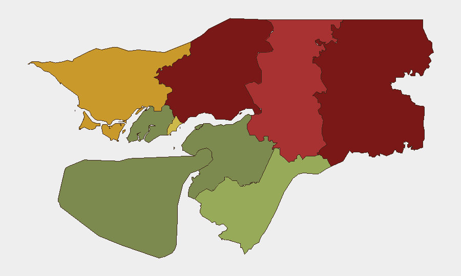
- Northern and eastern regions sustain chronic risk drivers. Gabu Region (risk score 92) remains the highest-risk area; Oio and Bafatá follow, reflecting ongoing trafficking, smuggling, and border-security challenges that predate the current reporting window.
Highest-Risk Areas
Gabu Region (northern, bordering Senegal and Guinea-Conakry) and Oio Region present the composite risk environment, driven primarily by chronic cross-border trafficking networks, weak state administrative presence, and porous customs infrastructure rather than active armed conflict or immediate organized-violence events. Bafatá Region extends this risk profile into the interior. By contrast, Bissau Autonomous Sector (risk 68), though containing the capital and seat of governance, ranks fifth due to institutional rather than field-level security vulnerabilities. Southern and coastal regions (Tombali, Quinara, Biombo, Bolama) carry significantly lower risk scores, reflecting stronger administrative reach and reduced trafficking activity.
How GeoBit Would Assist
Corporate security teams with personnel or assets in Guinea-Bissau should employ AOI Monitoring & Early Warning on Gabu and Oio regions to detect emerging trafficking networks, border incidents, or political spillover from neighboring states. Multi-language OSINT and X/Twitter/Telegram monitoring paired with sentiment and temporal analysis will provide real-time visibility into local political and civil unrest signals, particularly around Bissau. Routing & Network Analysis capabilities enable identification of secure travel corridors away from high-risk northern zones for personnel movement, and GIS & Spatial Analysis supports site-security planning for fixed facilities outside the capital.
7-Day Outlook
No acute escalation is forecast for the next seven days absent new political triggers or cross-border incidents. The military transition is likely to remain administratively fluid but operationally stable. Monitoring should remain focused on social-media and local-outlet signals for any re-emergence of political tension or organized activity in Bissau and the northern regions; current quiet does not eliminate latent institutional fragility.
Highest-Risk Areas — Ranked
| # | State / Region | Risk |
|---|---|---|
| 1 | Gabu Region | 92 |
| 2 | Oio Region | 85 |
| 3 | Bafatá Region | 78 |
| 4 | Cacheu Region | 72 |
| 5 | Bissau Autonomous Sector | 68 |
| 6 | Tombali Region | 45 |
| 7 | Quinara Region | 38 |
| 8 | Biombo Region | 32 |
| 9 | Bolama Region | 15 |
Sources
Previous Daily Briefs
A new Guinea-Bissau brief is written every day — each with its own risk map and downloadable CSV. Here's the last week; use the calendar to go further back.
📅 Browse every day by calendar →
Highlighted days have a brief. Tap a day for that day's map & analysis, or “csv” for that day's dataset ($5).
Atlas — our AI intelligence desk — emails them this snapshot personally. Nothing else, no list.