Situation Summary
Haiti remains at elevated and sustained threat level (rank #29 globally, composite score 65) driven by endemic gang violence, kidnapping for ransom, and political instability. The security environment has shown no material improvement over the past 24–48 hours; current indexed reporting does not surface discrete, localized incidents from June 30–July 1 that would indicate sudden deterioration or localized flashpoints. The underlying structural conditions—gang control of Port-au-Prince neighborhoods, sporadic armed clashes, and weak state capacity—persist and continue to warrant Level 4 "Do Not Travel" guidance for most areas.
Key Developments
Current open-source reporting does not reliably surface specific, timestamped security incidents (shootings, kidnappings, roadblocks, or clashes) from Haiti on June 30–July 1, 2026 that meet confirmation thresholds for inclusion in an operational brief. Web search results are dominated by U.S. legal coverage of the June 25, 2026 *Mullin v. Doe* decision (termination of Temporary Protected Status for Haitians), which is a U.S. immigration development with indirect Haiti implications, not a discrete Haiti security event.
Recent event signals tracked by GeoBit (June 29–30) include official statements, administrative rejections, and investigative actions at the national level, suggesting ongoing political and judicial friction but not yet confirmed as discrete public-safety or security incidents on the ground.
Recommendation: Organizations with operations or personnel in Haiti should rely on continuous AOI (area-of-interest) monitoring and intelligence fusion rather than waiting for 24–48-hour cycle updates. The operating environment changes slowly; actionable warning typically emerges from sustained pattern analysis rather than individual incident reports.
Highest-Risk Areas
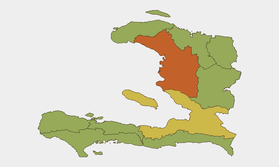
Artibonite Department (risk 75.5) is by significant margin the highest-threat sub-national zone, reflecting gang presence, kidnapping activity, and limited state authority. The Ouest Department (63.7) remains the second-most volatile, encompassing the capital Port-au-Prince and its surrounding metropolitan zones where most organized violence, kidnapping-for-ransom, and armed gang competition occurs. The remaining eight departments cluster at 45.5, indicating lower but still material risk from gang spillover, localized violence, and unreliable law enforcement.
Organizations should treat Artibonite and Ouest as off-limits or requiring exceptional security measures (armed escort, secure facilities, restricted movement windows); all other departments warrant heightened situational awareness and contingency planning.
How GeoBit Would Assist
Security and duty-of-care teams should deploy AOI Monitoring & Early Warning on critical locations (offices, residences, supply routes, border crossings) to detect changes in gang activity, checkpoint placement, or armed movement in real time. Intelligence Sweep (OSINT fusion, social-media monitoring, multi-language search, and entity extraction) applied to Haitian sources and diaspora networks provides earlier warning of political fracture, deportation or migration surges, or localized security breakdowns than traditional news cycles. Conflict & Military analysis (force structure, gang network mapping, and weapons capability) combined with GIS & Spatial Analysis supports route planning and movement risk assessment for personnel or cargo.
7-Day Outlook
No imminent tactical escalation is signaled by available reporting. The legal/political event signals (rejections, investigations, statements) suggest ongoing governance friction that could manifest in street-level disruption if tensions sharpen, but timing and geography remain uncertain. Organizations should maintain current posture: continuous monitoring, restrictive movement policies in Artibonite and Ouest, and prepared evacuation procedures.
Highest-Risk Areas — Ranked
| # | State / Region | Risk |
|---|---|---|
| 1 | Artibonite Department | 75.5 |
| 2 | de l'Ouest Department | 63.7 |
| 3 | Grande-Anse Department | 45.5 |
| 4 | Sud Department | 45.5 |
| 5 | Nippes Department | 45.5 |
| 6 | Nord-Ouest Department | 45.5 |
| 7 | Nord Department | 45.5 |
| 8 | Nord-Est Department | 45.5 |
| 9 | Centre Department | 45.5 |
| 10 | Sud-Est Department | 45.5 |
Sources
Previous Daily Briefs
A new Haiti brief is written every day — each with its own risk map and downloadable CSV. Here's the last week; use the calendar to go further back.
📅 Browse every day by calendar →
Highlighted days have a brief. Tap a day for that day's map & analysis, or “csv” for that day's dataset ($5).