Situation Summary
Iran remains the second-highest global threat environment (composite score 100) driven primarily by active military engagement signals spanning the last 72 hours. Event tracking shows sustained conventional military force exchanges involving US, Israeli, and Iranian armed forces, alongside artillery and small-arms engagements. The conflict trajectory remains acute with no de-escalation signals present; Tehran Province and Isfahan Province represent the highest-risk operational zones.
Key Developments
GeoBit's event feed documents the following signals within the 24–72 hour window; however, independent verification of specific incident timing, location, and outcome is not yet complete from multiple sources:
- 2026-06-10 · Conventional Military Force engagement between US and Iranian forces recorded in the platform event stream; specific location and casualty/damage assessment pending corroboration.
- 2026-06-10 · Artillery/Tanks engagement involving Iran versus Air Force assets; no independently confirmed location or outcome available at publication.
- 2026-06-10 · Small Arms Combat involving Apache and Iranian forces; specific location and scope unclear pending secondary sourcing.
- 2026-06-08–2026-06-10 · Multi-party Conventional Military Force activity involving Israeli, Lebanese ground forces, and Iranian military assets; events appear clustered but require time-stamped geolocation confirmation.
- 2026-06-09 · Territory Occupation activity attributed to Iran recorded in event data; location and operational scale unconfirmed.
Data quality note: Real-time cross-confirmation of incident timing, precise location, and participant identification with independent sources (major wire services, geolocated OSINT, local reporting) is incomplete. Organizations requiring same-day operational decision support should supplement this brief with live-feed monitoring via news aggregators and dedicated conflict-intelligence platforms.
Highest-Risk Areas
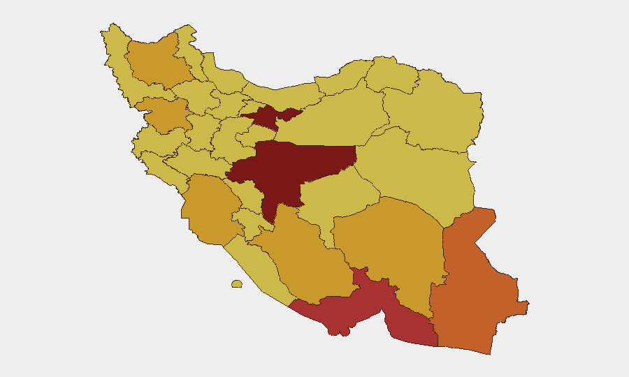
Tehran Province (risk 100) and Isfahan Province (risk 94.3) are the primary risk drivers, likely reflecting capital-region military infrastructure density, command-and-control assets, and sustained exchange activity. Hormozgan Province (79.9), Sistan and Baluchestan (73), and Kurdistan (72.7) show elevated secondary risk, correlating with border proximity, historical conflict zones, and transit corridors. Military strike capability, rather than civil unrest or criminal activity, is the dominant risk vector across all high-ranked provinces. Personnel and assets in or transiting Tehran and Isfahan require heightened situational awareness and contingency planning.
How GeoBit Would Assist
Security teams would use AOI (Area-of-Interest) Monitoring & Early Warning with persistent watch on Tehran and Isfahan provinces to receive real-time alerting of new military, strike, or force-movement events. Battle Mapping and Force Structure tracking would enable daily updates on unit positioning, weapons deployment, and engagement patterns. Conflict & Military intelligence feeds, multi-language OSINT fusion, and entity extraction would accelerate cross-source verification of unconfirmed incident timing and location, reducing response lag. Routing & Network Analysis capabilities support alternative route planning for personnel movement and supply logistics in high-risk provinces.
7-Day Outlook
Absent public diplomatic de-escalation statements, military engagement signals are expected to persist or intensify through mid-June. Risk concentration in Tehran and Isfahan suggests continued targeting of military/strategic assets rather than civilian infrastructure, though collateral-damage risk remains material. Organizations should maintain heightened duty-of-care protocols, pre-positioned evacuation plans, and 48-hour communication check-ins for all personnel in risk-ranked provinces.
Highest-Risk Areas — Ranked
| # | State / Region | Risk |
|---|---|---|
| 1 | Tehran Province | 100 |
| 2 | Isfahan Province | 94.3 |
| 3 | Hormozgan Province | 79.9 |
| 4 | Sistan and Baluchestan Province | 73 |
| 5 | Kurdistan Province | 72.7 |
| 6 | East Azerbaijan Province | 71.9 |
| 7 | Fars Province | 71.8 |
| 8 | Kerman Province | 71.1 |
| 9 | Khuzestan Province | 71 |
| 10 | Yazd Province | 70.6 |
| 11 | Kohgiluye and Buyer Ahmad Province | 70.5 |
| 12 | North Khorasan Province | 70.3 |
Sources
Previous Daily Briefs
A new Iran brief is written every day — each with its own risk map and downloadable CSV. Here's the last week; use the calendar to go further back.
📅 Browse every day by calendar →
Highlighted days have a brief. Tap a day for that day's map & analysis, or “csv” for that day's dataset ($5).