Situation Summary
Israel remains at composite threat level #11 globally, driven by active multi-front military and diplomatic escalation. The past 24–48 hours show sustained conventional military posturing and rhetoric from Iran, reduced diplomatic relations with Syria, Yemen, and Iraq, and continued artillery/tank activity from Lebanon. The trajectory indicates heightened regional tension with no clear de-escalation signals; South District remains critically elevated at 99.6 risk.
Key Developments
- 2026-06-17 · Iran–Israel Military Posture: Conventional military force signaling reported between Iran and Israel; accompanied by Iranian disapproval statements. Specifics on location and force positioning remain under assessment.
- 2026-06-17 · Syria Relations Downgrade: Israel reduced relations with Syria; geopolitical implication suggests further isolation of Damascus in regional calculus, likely linked to broader Iran–Syria–Hezbollah nexus.
- 2026-06-17 · Yemen & Iraq Diplomatic Downgrade: Israel reduced relations with both Yemen and Iraq simultaneously, signaling broader regional diplomatic isolation.
- 2026-06-15 · Lebanon Artillery/Tank Activity: Cross-border artillery and tank fire reported from Lebanon into Israel; indicates Hezbollah or Lebanese Armed Forces engagement, consistent with North District elevated risk (72).
- 2026-06-15 · Tehran Disapproval Statement: Iranian leadership publicly disapproved of Israeli actions; rhetorical escalation accompanying military signaling.
- 2026-06-17 · Rejection & Public Statement: Israeli rejection of unspecified demand and public statement issued; likely tied to ceasefire or regional mediation proposals (contextual references suggest US–Iran ceasefire discussions underway, but Israel's specific stance requires clarification).
Assessment caveat: Live web research for the past 24–48 hours returned limited time-stamped incident data beyond diplomatic and military signaling. Reports of Israeli strikes on Hezbollah-linked sites (70+ targets over an unspecified recent period) circulated but lack precise date/location confirmation. Recommend activation of real-time monitoring (see *How GeoBit Would Assist*) to close intelligence gaps.
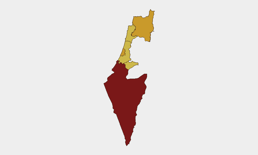
Highest-Risk Areas
South District (99.6) dominates the threat landscape, reflecting active ground and rocket threat from Gaza and southern border zones. North District (72) ranks second, driven by Lebanon border artillery, Hezbollah positioning, and potential Syrian instability. Tel-Aviv, Haifa, Center, and Jerusalem districts cluster at 69–71 risk, indicating threat diffusion across population centers and transportation hubs via rocket/missile reach and secondary attack vectors. The concentration of risk in border regions (South, North) and major urban centers reflects both direct kinetic threat (artillery, small arms, rockets) and second-order risks (civilian displacement, infrastructure disruption, supply-chain exposure).
How GeoBit Would Assist
Corporate security teams should deploy AOI Monitoring & Early Warning on South and North Districts with real-time alerting on artillery, drone, or cross-border activity. Intel Sweep and multi-language OSINT fusion (X, Telegram, Arabic media) will track Iranian and Lebanese actor statements, force movements, and ceasefire negotiations in near real-time. Routing & Network Analysis enables duty-of-care teams to model alternative travel and supply routes around active conflict zones and identify safe corridors for personnel and asset movement.
7-Day Outlook
Military signaling and diplomatic downgrade trajectory suggests sustained tension through mid-week with incremental risk of tactical escalation (cross-border fire, limited strikes). No imminent large-scale conventional operation is evident, but absence of de-escalation rhetoric or third-party mediation breakthroughs increases volatility. Teams should maintain heightened alert posture on South and North Districts and review contingency protocols for rapid personnel relocation and supply reroute.
Highest-Risk Areas — Ranked
| # | State / Region | Risk |
|---|---|---|
| 1 | South District | 99.6 |
| 2 | North District | 72 |
| 3 | Tel-Aviv District | 71.4 |
| 4 | Haifa District | 69.6 |
| 5 | Center District | 69.6 |
| 6 | Jerusalem District | 69.6 |
Previous Daily Briefs
A new Israel brief is written every day — each with its own risk map and downloadable CSV. Here's the last week; use the calendar to go further back.
📅 Browse every day by calendar →
Highlighted days have a brief. Tap a day for that day's map & analysis, or “csv” for that day's dataset ($5).