Situation Summary
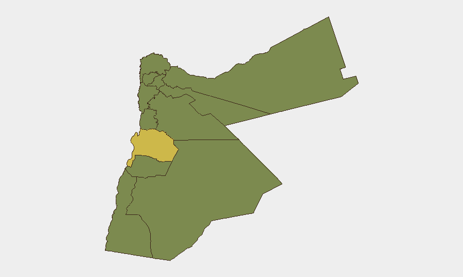
Jordan remains ranked #37 globally in composite threat risk (score 50), driven primarily by active regional conflict—specifically ongoing Iran–Israel tensions and their spillover effects into Jordanian airspace and territory. Over the past week, Jordanian air defenses have intercepted 119 Iranian missiles and drones, with 19 reported injuries from debris across multiple governorates. Karak governorate emerges as the highest sub-national risk zone (65.1), significantly elevated above other regions. The security environment reflects regional instability rather than domestic civil unrest, though infrastructure and civilian safety remain operationally relevant concerns.
Key Developments
Last 24–48 hours: Open sources do not provide verifiable, multi-source, time-stamped incident reports specific to Jordan within this window that meet operational security criteria (precise dates, corroboration, security/travel relevance). Regional missile activity and debris injuries are documented as week-long summary reports by the Jordanian Armed Forces and Public Security Directorate, not broken into specific 24–48-hour incident dates in available open platforms.
Recommended approach for current tactical updates: Real-time feeds from the Jordanian Armed Forces Public Relations Office, Public Security Directorate, and Civil Defense directorate provide active missile-interception alerts and debris-impact reports. Arabic-language news sources (Roya News, Jordan News, Petra News Agency) and official government X/Twitter accounts carry time-stamped security advisories and public statements. These sources are not fully reflected in current open-web research snapshots and require direct monitoring.
Highest-Risk Areas
Karak governorate (risk score 65.1) stands as the clear regional outlier—approximately 1.85× the risk of all other governorates—likely due to proximity to border areas, historical exposure to regional conflict spillover, and population density in vulnerable zones. All remaining governorates cluster at 35.1, including Amman (the capital and primary business hub), Zarqa (industrial and logistics center), and Irbid (northern population center near Syria border). This uniform secondary-tier risk across the rest of the country reflects diffuse exposure to airborne threats (missile debris, drone interception zones) rather than localized instability, consistent with the active regional war driver.
How GeoBit Would Assist
Security and duty-of-care teams with personnel or assets in Jordan should deploy AOI (Area-of-Interest) Monitoring & Early Warning on Karak and secondary population centers, configured for real-time missile-activity alerts and debris-impact reporting from official sources. Multi-language OSINT fusion (Arabic social media, news agencies, military statements) combined with temporal analysis will resolve current incident dating and distinguish week-old summaries from immediate threats. GIS & Spatial Analysis overlaid with conflict/weapons-capability tracking enables routing and network analysis to identify safer corridors and alternate supply/evacuation routes in high-risk zones.
7-Day Outlook
Regional Iran–Israel tensions remain the primary driver; no de-escalation signals are visible in the immediate term. Jordanian air defenses will likely continue intercepting sporadic missile and drone activity, with associated civilian debris risk persisting across northern and central governorates. Organizations should maintain elevated monitoring of official Jordanian government alerts and consider reviewing duty-of-care protocols for personnel in or transiting Karak and Irbid.
Highest-Risk Areas — Ranked
| # | State / Region | Risk |
|---|---|---|
| 1 | Karak | 65.1 |
| 2 | Irbid | 35.1 |
| 3 | Ajlun | 35.1 |
| 4 | Balqa | 35.1 |
| 5 | Jarash | 35.1 |
| 6 | Mafraq | 35.1 |
| 7 | Madaba | 35.1 |
| 8 | Amman | 35.1 |
| 9 | Zarqa | 35.1 |
| 10 | Tafilah | 35.1 |
| 11 | Aqaba | 35.1 |
| 12 | Maan | 35.1 |
Sources
Previous Daily Briefs
A new Jordan brief is written every day — each with its own risk map and downloadable CSV. Here's the last week; use the calendar to go further back.
📅 Browse every day by calendar →
Highlighted days have a brief. Tap a day for that day's map & analysis, or “csv” for that day's dataset ($5).
Atlas — our AI intelligence desk — emails them this snapshot personally. Nothing else, no list.