Situation Summary
Latvia remains in a low-incident security environment with no verified major security, civil unrest, crime, or infrastructure incidents in the last 24–48 hours. The country's overall threat profile is characterized by chronic, rather than acute, risk: an elevated border-security posture along the Belarus frontier (extended through 31 December 2026), persistent but undated concerns over regional drone incursions and cyber pressure in the Baltic airspace, and ongoing irregular migration activity in eastern municipalities. The trajectory is stable but operationally constrained in border regions.
Key Developments
- No new discrete security incidents reported in Latvia in the last 24–48 hours across verified news, OSINT feeds, and regional outlets.
- Enhanced border-security regime ongoing (eastern municipalities, decision 30 June 2026): Ludza, Krāslava, Augšdaugava, Daugavpils, and Kaunata Parish remain under heightened state controls due to irregular migration and national-security concerns; this structural measure shapes travel and operational security in those areas through end-year.
- Latvia–Ukraine defense cooperation (Riga, 30 July 2026): Security memorandum signed to develop competitive unmanned-systems and defense-innovation ecosystem. No direct incident, but reflects evolving regional security partnerships and strategic environment.
- Regional cyber and airspace threat environment (Baltic region, late July 2026): Ongoing reporting of drone incursions and heightened cyber risk along NATO's Baltic borders, including Latvia, but no clearly dated, Latvia-specific incident in the current 24–48 hour window; this is a chronic rather than acute concern.
Highest-Risk Areas
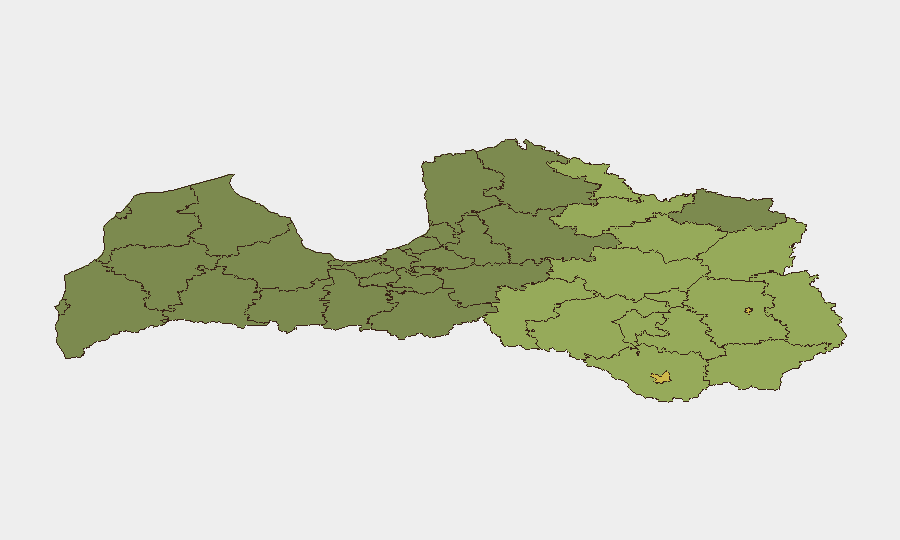
Rēzekne and Daugavpils dominate the sub-national risk ranking (68 and 65 respectively), followed by their surrounding novads (Rēzeknes, Ludzas, Balvu, Preiļu). The concentration of risk in eastern border municipalities reflects the structural drivers: irregular migration pressure, enhanced state-security operations, and proximity to Belarus. The gradient from east (highest risk) to west and central regions reflects the geography of migration routes and border operations; Riga and central Latvian cities show materially lower risk scores. Risk in these eastern areas is not acute-incident-based but rather operational-environment-based—travel restrictions, police presence, and border procedures are the primary security considerations for personnel and asset movement.
How GeoBit Would Assist
Security teams with personnel or assets in Latvia's eastern border regions would benefit from AOI Monitoring & Early Warning capabilities focused on Rēzekne, Daugavpils, and surrounding novads to detect any escalation in irregular migration, unrest, or cross-border incidents. Intel Sweep and OSINT Fusion capabilities (X/Twitter, Telegram, regional news, multi-language search) would provide 24–48 hour situational updates and early warning of any discrete incidents or unrest, particularly in high-risk municipalities. Routing & Network Analysis would support security and duty-of-care teams in planning alternative travel routes or identifying operational constraints imposed by enhanced border-security regimes.
7-Day Outlook
No significant near-term escalation is anticipated in Latvia's security environment. The border regime, drone/cyber concerns, and eastern municipal risk posture are expected to remain stable and structural through the forecast window. Continued monitoring of irregular migration flows and any spillover from regional cyber or airspace incidents remains prudent.
Highest-Risk Areas — Ranked
| # | State / Region | Risk |
|---|---|---|
| 1 | Rēzekne | 68 |
| 2 | Daugavpils | 65 |
| 3 | Rēzeknes novads | 58 |
| 4 | Ludzas novads | 55 |
| 5 | Balvu novads | 52 |
| 6 | Preiļu novads | 50 |
| 7 | Krāslavas novads | 48 |
| 8 | Jēkabpils novads | 47 |
| 9 | Augšdaugavas novads | 46 |
| 10 | Aizkraukles novads | 45 |
| 11 | Varakļānu novads | 44 |
| 12 | Līvānu novads | 43 |
Sources
Previous Daily Briefs
A new Latvia brief is written every day — each with its own risk map and downloadable CSV. Here's the last week; use the calendar to go further back.
📅 Browse every day by calendar →
Highlighted days have a brief. Tap a day for that day's map & analysis, or “csv” for that day's dataset ($5).
Atlas — our AI intelligence desk — emails them this snapshot personally. Nothing else, no list.