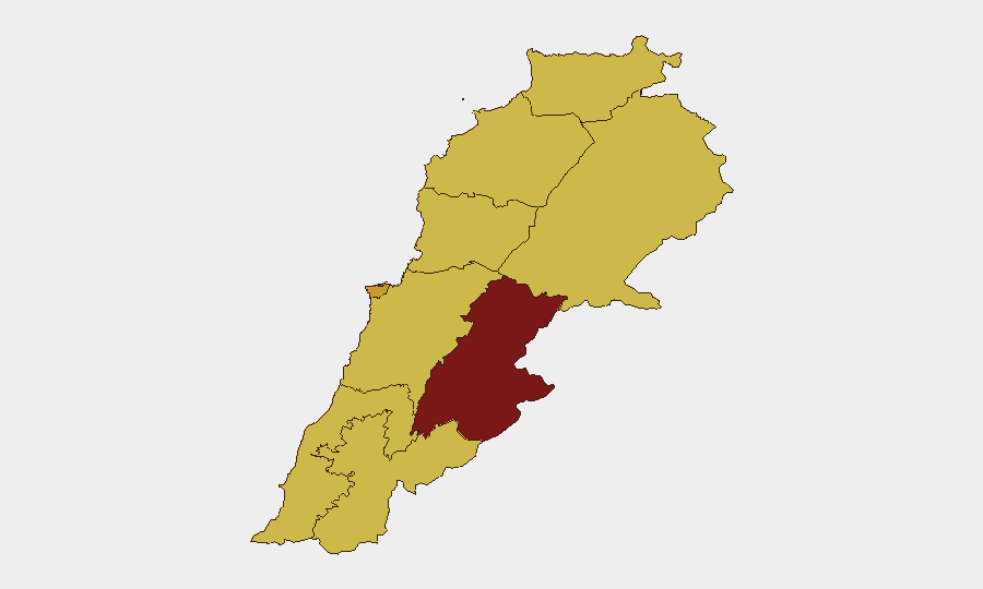
Situation Summary
Lebanon faces acute military escalation along its southern border and internal political fracture, with Israeli forces conducting sustained ground operations against Hezbollah infrastructure while Lebanese state institutions remain weakened. The 24-hour event signal shows cross-border threats, internal armed clashes, and aerial weapons deployment alongside diplomatic appeals from Tehran and UNESCO concerns. The country ranks #12 globally for composite threat (score 87; 158 tracked events), with trajectory trending toward deeper Israeli-Hezbollah confrontation and potential state instability.
Key Developments
- Nabatieh Governorate, southern Lebanon — 2026-06-11 — IDF forces advanced toward a major offensive posture against Hezbollah, while Hezbollah drones inflicted moderate injuries on Israeli troops; concurrent small-arms combat reported between Lebanese actors and civilian populations.
- Wadi Saluki stream area, southern Lebanon — 2026-06-11 — IDF conducted a raid achieving reported "operational control" and clearing Hezbollah infrastructure; artillery and conventional military force deployed.
- Tyre vicinity, southern Lebanon — 2026-06-11 — A strike impacted 15 meters from Hiram hospital, wounding 10 hospital staff; civilian infrastructure exposure underscores escalation pattern.
- Baalbek region, eastern Lebanon — 2026-06-11 — Israeli airstrikes confirmed on southern areas and Baalbek village; signals show aerial weapons employment expanding northward.
- Beaufort Castle area, southern Lebanon — 2026-06-11 — Multiple Hezbollah operatives killed after extraction from tunnel system; indicates sustained Israeli air-ground coordination.
- South Lebanon border, multiple firing incidents — 2026-06-11 — Two Hezbollah rocket strikes near Israeli operating positions; ongoing cross-border indirect fire.
- Pentagon, Washington — 2026-06-12 — Lebanese and Israeli military delegations scheduled for US-brokered security talks; Lebanese delegation prioritizing ceasefire framework, signaling state-level attempt to constrain escalation.
Highest-Risk Areas
Beqaa Governorate (90.9) dominates sub-national risk, driven by Iranian logistics networks, Hezbollah military infrastructure, and exposure to Israeli deep-strike capability. Beirut Governorate (71.9) ranks second due to state fragility, political paralysis on security decisions, and civilian density in contested urban terrain. South Governorate (61.6) and Nabatieh (62.4) jointly constitute the active kinetic front, where Israeli ground operations, Hezbollah retaliation, and civilian exposure create immediate casualty risk. Northern and eastern governorates (Akkar, Baalbek-Hermel, North) score similarly elevated (60.9) due to Iranian presence, cross-border weapons flows, and indirect-fire employment.
How GeoBit Would Assist
Battle mapping and force-structure tracking enable real-time monitoring of Israeli and Hezbollah unit dispositions, positioning, and redeployment patterns—critical for duty-of-care teams predicting movement corridors and escalation vectors. AOI monitoring with alerting on Beqaa, Nabatieh, and South governorates provides persistent watch for new strikes, weapons employment, or humanitarian emergencies, with automated trigger notification to corporate security. Conflict and weapons-capability tracking, paired with satellite and imagery analysis, identify new Israeli staging areas, Hezbollah tunnel networks, and infrastructure damage—enabling teams to assess access denial and route viability for personnel or supply chains.
7-Day Outlook
Pentagon talks (2026-06-12) offer a narrow diplomatic window, but Israeli military posture suggests continued ground operations in South Governorate irrespective of ceasefire messaging. Beqaa and Baalbek remain exposed to deeper Israeli strikes if Iranian or Hezbollah logistics are targeted. Civilian displacement, hospital impacts, and Lebanese state inability to enforce ceasefires will likely persist, elevating humanitarian and duty-of-care risks across Beirut and southern border zones through mid-June.
Highest-Risk Areas — Ranked
| # | State / Region | Risk |
|---|---|---|
| 1 | Beqaa Governorate | 90.9 |
| 2 | Beirut Governorate | 71.9 |
| 3 | Nabatieh Governorate | 62.4 |
| 4 | South Governorate | 61.6 |
| 5 | North Governorate | 60.9 |
| 6 | Akkar Governorate | 60.9 |
| 7 | Keserwan-Jbeil Governorate | 60.9 |
| 8 | Mount Lebanon Governorate | 60.9 |
| 9 | Baalbek-Hermel Governorate | 60.9 |
Sources
Previous Daily Briefs
A new Lebanon brief is written every day — each with its own risk map and downloadable CSV. Here's the last week; use the calendar to go further back.
📅 Browse every day by calendar →
Highlighted days have a brief. Tap a day for that day's map & analysis, or “csv” for that day's dataset ($5).