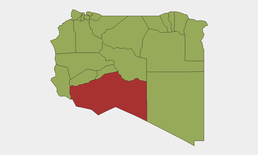
Situation Summary
Libya remains at elevated risk (#27 globally, composite threat score 69) with 42 tracked security events. The security environment is characterized by localized armed clashes, critical infrastructure disruptions, and ongoing political friction with international actors. Current indicators suggest persistent instability concentrated in southwestern and central regions, though open-source reporting for the last 24–48 hours is fragmentary and poorly time-stamped, limiting real-time situational clarity.
Key Developments
- Zawiya refinery shutdown (timing recent, not confirmed within 48h). Libya's National Oil Corporation confirmed closure of the Zawiya oil refinery—the country's largest facility—following armed clashes in the vicinity. The facility is located west of Tripoli in Az Zawiya District (risk score 48.5) and serves critical national energy production. Travel and operations near the refinery face elevated risk of crossfire and sudden closures.
- Multiple arrest/detention events (2026-06-11 to 2026-06-12). Law enforcement actions recorded against migrants, citizens, and a lawyer within the last two days signal tightened police/security operations. Specific locations and scale remain unclear from available reporting; recommend direct embassy/UN OCHA contact for detail.
- Public statements and rejections by state/constituent actors (2026-06-12). Multiple public statements and formal rejections issued by Libyan political actors and constituent groups relative to UN engagement and sovereignty questions indicate ongoing governance friction. Content and specific demands are not clarified in current feeds; monitoring of Libyan political media and UN correspondence is advised.
- Tobruk security cooperation agreement discussion (timing uncertain, likely pre-2026-06-12). Libyan and Chinese officials discussed expanded security cooperation, training, and infrastructure projects (refinery, rail link) in eastern Libya. While not an acute incident, this signals medium-term strategic alignment and potential for increased foreign military/security presence in Tobruk region.
- Sparse, fragmented open reporting. Critical reporting gaps exist: event dating is inconsistent, geographic specificity is often absent, and most situational intelligence relies on social media and local outlets rather than confirmed news wires. Organizations operating in Libya should not rely on open-source feeds alone for operational decisions.
Highest-Risk Areas
Murzuq (risk 78.5) in the Fezzan southwest dominates the threat profile, likely reflecting ongoing militia activity, trafficking, and resource competition in that remote region. The second tier—Sirte (50.7) and Tripoli (49.0)—indicates risk concentrated in Libya's central and northern coastal belt, where state authority is contested and criminal/militant networks operate. The remaining high-risk areas (Nalut, Ghat, Az Zawiya, and nine others at 48.5) reflect a broad underlying fragility across the country rather than isolated hotspots; this suggests risks are geographically dispersed and that no region can be treated as secure baseline.
How GeoBit Would Assist
Intel Sweep and OSINT fusion across X/Telegram, local Arabic media, and event feeds provide near-real-time signal correlation to distinguish confirmed incidents from rumor. AOI Monitoring and Early Warning on Murzuq, Zawiya, Tripoli, and Tobruk—with persistent watch and alerting—would flag clashes, arrests, and infrastructure disruptions before they impact travel or operations. Routing and Network Analysis would enable rapid identification of alternative routes and safe corridors when primary infrastructure (roads, ports, refinery access) becomes compromised.
7-Day Outlook
Armed clashes and police operations are expected to persist at current low-to-moderate frequency in high-risk zones, with sporadic disruptions to energy, transport, and commerce. Governance friction over UN engagement and sovereignty issues is likely to generate additional public statements but carries lower immediate operational risk unless linked to localized armed conflict. Organizations should assume information asymmetry (poor real-time reporting) will persist and plan contingencies for rapid asset relocation or supply-chain rerouting in southwestern and central regions.
Highest-Risk Areas — Ranked
| # | State / Region | Risk |
|---|---|---|
| 1 | Murzuq | 78.5 |
| 2 | Sirte | 50.7 |
| 3 | Tripoli | 49 |
| 4 | Nalut | 48.5 |
| 5 | Ghat | 48.5 |
| 6 | Baladiyah Surman | 48.5 |
| 7 | Az Zawiya District | 48.5 |
| 8 | Wadi al Shatii | 48.5 |
| 9 | Wadi al Hayaa | 48.5 |
| 10 | Kufra | 48.5 |
| 11 | Nuqat al Khams | 48.5 |
| 12 | Jafara | 48.5 |
Sources
Previous Daily Briefs
A new Libya brief is written every day — each with its own risk map and downloadable CSV. Here's the last week; use the calendar to go further back.
📅 Browse every day by calendar →
Highlighted days have a brief. Tap a day for that day's map & analysis, or “csv” for that day's dataset ($5).