Situation Summary
Mali remains at elevated composite threat level (rank #19 globally, score 73.2), driven primarily by active insurgency across the Sahel and central regions. Recent diplomatic and political signaling—spanning government, opposition, media, and international actors (UEMOA, France)—indicates fluid tensions alongside sustained military operations against designated terrorist organizations. The security environment remains volatile with asymmetric threats dispersed across 11 high-risk administrative zones; no significant de-escalation is evident.
Key Developments
- 2026-06-11 · Conventional Military Operations. Malian armed forces engaged in active military action against terrorist-designated groups. Specific location(s) and casualty figures not yet multi-source confirmed in open reporting.
- 2026-06-11 · Government–Opposition Political Signal. Mali government issued public statement; opposition separately signaled disapproval (2026-06-10). Nature of dispute and location of any related civil unrest not yet clearly specified in available open sources.
- 2026-06-11 · International Diplomatic Signal. Mali government issued public statement regarding France; UEMOA (West African monetary union) also issued statement 2026-06-09. Substance of statements and operational implications for security posture remain unclear from headline-level reporting.
- 2026-06-11 · Criminal Activity Signal. Criminal actor(s) issued public statement. Geographic scope and nature of activity not yet detailed in confirmed reporting.
- 2026-06-11 · Resident Grievance. Residents issued rejection statement against Mali authorities. Location and underlying cause not yet specified in multi-source confirmation.
- 2026-06-09–10 · Media and International Statements. Media outlets issued statement regarding Mali; REPRESENTATIVES and GOVERNMENT both issued public statements. Full context and any civil-unrest or security implications remain unclear.
- 2026-06-10 · External Threat Signal. Somalia-linked actor issued threat statement. No confirmed operational incidents or territorial claims yet reported.
Note: Open-source reporting in the last 24–48 hours does not yet contain clearly time-stamped, multi-source-confirmed incident detail (location, casualty count, or organizational attribution) for most signals listed above. Security and risk teams should cross-reference dedicated real-time incident platforms and embassy advisories for operational detail.
Highest-Risk Areas
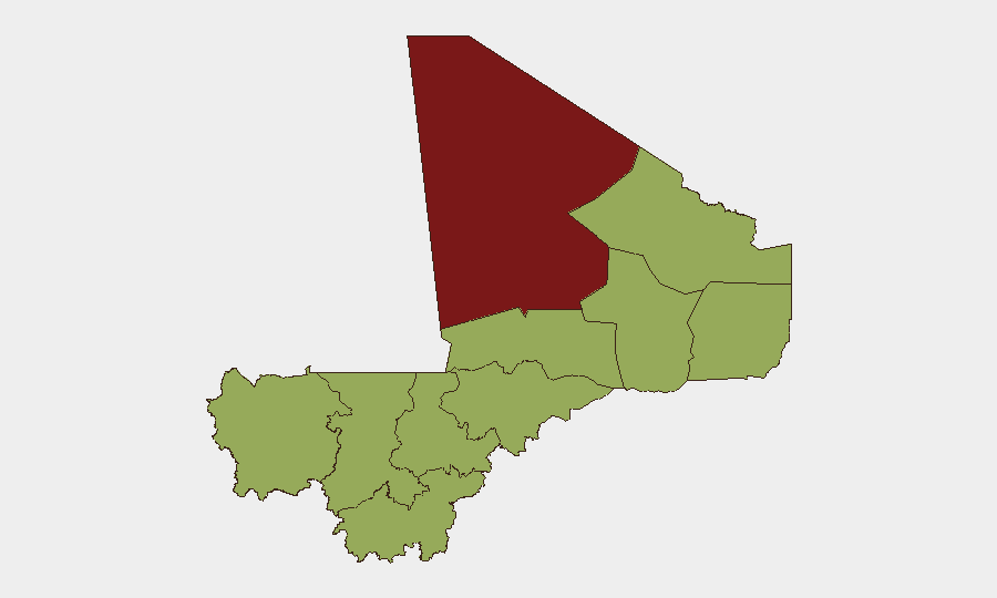
Taoudénit Region dominates the sub-national risk ranking (81.2), reflecting sustained insurgent presence and limited state control. Timbuktu (59.1), Bamako (52.8), and Mopti (52.8) follow; nine additional regions score at 51.2, indicating dispersed and persistent threat across the country's northern, central, and western territories. Bamako's inclusion in the top tier underscores urban security concerns alongside rural insurgency. The broad geographic spread of moderate-to-high risk suggests that no region is currently assessed as secure, and that supply lines, personnel movement, and asset locations across all 11 flagged zones warrant continuous monitoring.
How GeoBit Would Assist
Intel Sweep and global event feeds combined with X/Twitter & Telegram OSINT and multi-language search enable real-time tracking of government, opposition, and militant actor statements—critical for early warning of political rupture or military escalation. AOI Monitoring & Early Warning with persistent watch on Taoudénit, Timbuktu, Mopti, and Bamako provides 24/7 alert coverage for incident confirmation, allowing duty-of-care teams to react before events spread. Battle mapping and force-structure analysis clarify military-vs.-insurgent positions and movement, informing safe-passage routing and asset-relocation decisions.
7-Day Outlook
Diplomatic and political signaling is expected to continue; military operations against designated groups will likely persist, particularly in the north and center. Risk of rapid localized escalation remains elevated, especially in Taoudénit and Timbuktu. Organizations should maintain heightened readiness for personnel evacuation or asset re-positioning if civil unrest or military activity intensifies near populated or operational areas.
Highest-Risk Areas — Ranked
| # | State / Region | Risk |
|---|---|---|
| 1 | Taoudénit Region | 81.2 |
| 2 | Timbuktu | 59.1 |
| 3 | Bamako | 52.8 |
| 4 | Mopti | 52.8 |
| 5 | Ménaka | 51.2 |
| 6 | Kayes | 51.2 |
| 7 | Kidal | 51.2 |
| 8 | Gao | 51.2 |
| 9 | Koulikoro | 51.2 |
| 10 | Ségou Region | 51.2 |
| 11 | Sikasso Region | 51.2 |
Sources
Previous Daily Briefs
A new Mali brief is written every day — each with its own risk map and downloadable CSV. Here's the last week; use the calendar to go further back.
📅 Browse every day by calendar →
Highlighted days have a brief. Tap a day for that day's map & analysis, or “csv” for that day's dataset ($5).