Situation Summary
Malta remains a low-threat environment (global composite score 5; no tracked discrete events in current window), but localized public-order incidents and police operational tempo have elevated real-time risk in central urban zones, particularly St Julian's and Valletta. Two serious assaults on police officers within 48 hours, combined with ongoing routine drug, weapons, and public-safety enforcement, signal persistent street-level disorder in nightlife and commercial districts. The trajectory is stable but tactically volatile in specific corridors.
Key Developments
- Ta' Giorni, St Julian's (Friday, late July): Police sergeant Johann Vella shot in face and neck during 90-minute standoff at construction site on Triq Joseph Carbone following suspect-initiated fire and gunfire; second officer Omar Sharif sustained minor injuries. Both suspects (pensioner John Agius and brother) arrested. Vella now stable in intensive care; magisterial inquiry ongoing. Union renewed demands for officer health insurance.
- Triq San Ġorġ, St Julian's (early morning, within last 24–48h): Police sergeant sustained head injuries after repeated punching while intervening in street altercation involving four Maltese nationals. Assailant hospitalized; investigation continuing. Second officer assault in same locality in 48 hours.
- Paceville, St Julian's (Saturday court hearing, late July): Two French nationals (19 years old) pleaded guilty to public urination fine escalation, police evasion, and disorderly conduct outside Sky Club. Case reflects persistent public-order demand in nightlife precinct.
- Nationwide preventive operations (last 24–48h round-up): Nine arrests reported for weapon carrying (cutlery), illegal drug possession, GBH, unlicensed stay, and drink-driving; indicates active street-level enforcement across multiple crime categories.
Highest-Risk Areas
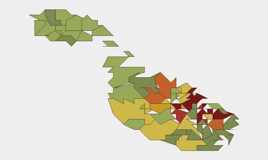
Valletta (95), Sliema (92), and St Julian's (90) dominate the sub-national ranking and collectively represent the primary exposure zones for corporate teams. St Julian's—encompassing Ta' Giorni and Paceville—has generated the highest volume of recent incident activity: two police assaults, a shooting standoff, and public-order cases all within 48 hours. Valletta and Sliema reflect baseline urban density, nightlife concentration, and transient populations. These three localities account for the majority of reported enforcement action and pedestrian-facing risk; peripheral localities (Żabbar 80, Cospicua 81) carry lower operational tempo.
How GeoBit Would Assist
AOI Monitoring & Early Warning would enable continuous watch over Valletta, St Julian's, and Sliema nightlife corridors and construction zones, flagging police incidents, gathering activity, or public-order escalation in real time. OSINT Fusion & Corroboration (X, Telegram, local news feeds, multi-language search) would surface emerging street-level unrest, officer safety alerts, or organized activity before escalation. Routing & Network Analysis would allow security teams to model alternative routes around high-incident zones (Ta' Giorni, Paceville) for personnel and asset movement, with dynamic re-routing as conditions evolve.
7-Day Outlook
Police operational intensity in central urban zones will likely remain elevated as inquiries into the Ta' Giorni shooting and St Julian's assaults proceed; court appearances and union advocacy may drive further public attention. Routine enforcement (weapons, drugs, public order) is expected to continue at current levels. No systemic destabilization is indicated, but localized street-level friction in nightlife and commercial districts should be factored into duty-of-care planning for personnel working or transiting Valletta, Sliema, and St Julian's during evening and early-morning hours.
Highest-Risk Areas — Ranked
| # | State / Region | Risk |
|---|---|---|
| 1 | Valletta | 95 |
| 2 | Sliema | 92 |
| 3 | Saint Julian's | 90 |
| 4 | Gżira | 88 |
| 5 | Hamrun | 87 |
| 6 | Paola | 86 |
| 7 | Msida | 85 |
| 8 | Birkirkara | 84 |
| 9 | Birgu | 83 |
| 10 | Senglea | 82 |
| 11 | Cospicua | 81 |
| 12 | Żabbar | 80 |
Sources
Previous Daily Briefs
A new Malta brief is written every day — each with its own risk map and downloadable CSV. Here's the last week; use the calendar to go further back.
📅 Browse every day by calendar →
Highlighted days have a brief. Tap a day for that day's map & analysis, or “csv” for that day's dataset ($5).
Atlas — our AI intelligence desk — emails them this snapshot personally. Nothing else, no list.