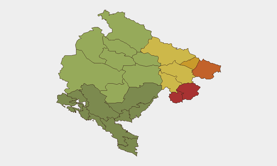
Situation Summary
Montenegro remains a low-threat environment overall, ranked #150 globally with composite threat score 5 and no significant security, conflict, civil-unrest, or infrastructure incidents confirmed in the last 24–48 hours. Current travel advisories from Australia, Germany, and Spain all characterize the country as safe, recommending normal precautions. However, sub-national risk concentrates heavily in the northern municipalities (Plav, Gusinje, Rožaje, Petnjica, Andrijevica), which carry elevated structural risk profiles; these areas warrant elevated monitoring for organizations with presence or movement there.
Key Developments
- 2026-07-12 · Public Statement by Corporation – Location and specific content not confirmed in available open-source feeds; appears to relate to corporate activity but timeframe and implications for security posture unclear.
- 2026-07-13 · Conventional Military Force activation by Authorities – Reported by GeoBI event signal; no geographic specificity or conflict context available in cross-checked sources; characterization as routine exercise, training, or response to specific incident cannot be confirmed.
- 2026-07-13 · Conventional Military Force action (Authorities vs Neighborhood) – Geographic focus and tactical nature not detailed in available reporting; no civilian impact or infrastructure disruption confirmed.
- 2026-07-13 · Political friction (Politician vs Captain) – Interpersonal or institutional disagreement noted; does not appear to have escalated to policy change, public unrest, or operational impact as of 14 July.
- Northern municipalities (Plav, Gusinje, Rožaje area) – Structural risk maintained – These zones continue to carry elevated risk ratings (78, 76, 74 respectively) on the basis of ongoing structural factors (border proximity, historical tensions, organized-crime proximity); no new acute incidents reported in the last 24–48 hours.
- Countrywide – No travel disruption, crime surge, or civil unrest – All major travel advisories, local news feeds, and open-source channels report a calm, stable security environment with only routine petty crime expected.
Highest-Risk Areas
The northern frontier municipalities—Plav, Gusinje, Rožaje, Petnjica, and Andrijevica—drive the country's elevated sub-national risk profile, with composite scores ranging from 78 to 68. These areas border Serbia and Kosovo, face historical inter-community tensions, and carry proximity to organized-crime networks and informal border-crossing activity. Risk is structural rather than acute; no recent incidents confirm imminent escalation, but organizations with personnel or assets in these zones should maintain heightened situational awareness and contingency protocols. Southern and central regions (Podgorica, coastal areas, Cetinje) carry substantially lower risk and remain suitable for routine operations under standard duty-of-care protocols.
How GeoBit Would Assist
Security teams with Montenegro operations would benefit from AOI Monitoring & Early Warning on the northern municipalities (Plav, Gusinje, Rožaje cluster) to detect emerging incidents in real time; Intel Sweep and multi-language OSINT (X, Telegram, local news) to maintain 24/7 signal on border activity, political friction, and crime trends; and Routing & Network Analysis to plan personnel movement and identify safer transit corridors avoiding high-risk zones. Satellite & Imagery analysis can support facility and infrastructure assessment in sensitive areas, and Network & Actor Analysis can clarify any connection between the corporation and military/political figures noted in the 12–13 July signals.
7-Day Outlook
No escalation indicators are present as of 14 July. The near-term trajectory remains stable, with the northern municipalities likely to retain their elevated structural risk posture but no acute triggers visible in 24–72-hour outlook windows. Organizations should maintain standard monitoring cadence and contingency readiness, with no immediate need for heightened alert status or travel restrictions.
Highest-Risk Areas — Ranked
| # | State / Region | Risk |
|---|---|---|
| 1 | Plav Municipality | 78 |
| 2 | Gusinje Municipality | 76 |
| 3 | Rožaje Municipality | 74 |
| 4 | Petnjica Municipality | 72 |
| 5 | Andrijevica Municipality | 68 |
| 6 | Bijelo Polje Municipality | 65 |
| 7 | Berane Municipality | 62 |
| 8 | Plužine Municipality | 58 |
| 9 | Pljevlja Municipality | 55 |
| 10 | Šavnik Municipality | 52 |
| 11 | Žabljak Municipality | 50 |
| 12 | Kolašin Municipality | 48 |
Sources
Previous Daily Briefs
A new Montenegro brief is written every day — each with its own risk map and downloadable CSV. Here's the last week; use the calendar to go further back.
📅 Browse every day by calendar →
Highlighted days have a brief. Tap a day for that day's map & analysis, or “csv” for that day's dataset ($5).
Atlas — our AI intelligence desk — emails them this snapshot personally. Nothing else, no list.