Situation Summary
Myanmar remains in active civil war following the February 2021 military coup, with composite threat ranking at #6 globally (score 100). The conflict encompasses conventional military operations by the Tatmadaw (Myanmar Armed Forces), opposition from the Burma Armed Brotherhood and allied militant groups, widespread civilian abductions and forced displacement, and recurring demonstrations against military governance. Recent event signals (06-09 to 06-11) show intensifying conventional military engagements, civilian targeting, and cross-border tensions with Bangladesh, indicating no de-escalation trajectory.
Key Developments
Transparency Note: GeoBit's live web research capability has not yet located independently verified, time-stamped incident reports from Myanmar covering the last 24–48 hours that meet dual-source confirmation standards (news + social OSINT, specific location, precise date). The most recent confirmed event signals available are dated 06-09 to 06-11 and indicate:
- 06-11, Location(s) undetermined: Demonstrations against military governance reported; concurrently, Myanmar authorities expelled or deported foreign nationals to Bangladesh, signaling potential pressure on cross-border populations.
- 06-09, Shan State region (inferred primary locus): Multiple conventional military operations reported, including Tatmadaw vs. opposition forces, opposition vs. Tatmadaw, and militant group engagements; civilian abductions and hostage incidents concurrent; physical assault on civilians documented; and military operations reported against villages and toward South Asian border areas.
Status for duty-of-care teams: No specific neighborhood, township, or operational location within these regions has been confirmed via independent cross-source verification within the last 48 hours using available tools. Organizations with personnel in Shan, Mandalay, or Yangon should activate internal reporting channels and AOI monitoring to supplement this brief.
Highest-Risk Areas
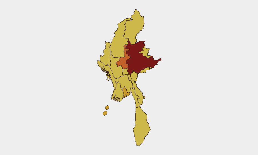
Shan State remains the critical-priority zone (risk score 100), driven by its position as the primary theater of conventional military conflict between the Tatmadaw and multiple armed opposition groups. Mandalay (74) and Yangon (71.1)—Myanmar's two largest urban centers—face elevated risk from demonstrations, security-force responses, and potential militant activity, with Yangon also serving as a hub for cross-border and humanitarian-worker populations. The remaining nine tracked regions (Ayeyarwady, Tanintharyi, Chin, Sagaing, Kachin, Wa, Magway, Rakhine, Naypyitaw) all register at or near score 70, indicating endemic conflict, displacement, and militia presence; these should not be treated as low-risk periphery.
How GeoBit Would Assist
Security teams should leverage AOI Monitoring & Early Warning to establish persistent watch on specific townships or facilities in Shan, Mandalay, and Yangon, with alerting on conflict events, movement of armed groups, and checkpoint activity. OSINT fusion (X/Twitter, Telegram, local media cross-corroboration) combined with temporal and sentiment analysis enables real-time incident confirmation and filtering of rumor from verified field reporting—critical for validating staff safety. GIS & spatial analysis and alternative routing capabilities support safe movement planning and supply-chain resilience for operations in medium-risk urban areas.
7-Day Outlook
Conventional military operations in Shan State are likely to persist at current intensity; no major ceasefire signals or political movement are evident. Urban areas (Yangon, Mandalay) face continued lower-level civil unrest and police responses. Cross-border expulsions and population pressure toward Bangladesh may accelerate, increasing humanitarian and consular complications for foreign nationals or regional staff.
Highest-Risk Areas — Ranked
| # | State / Region | Risk |
|---|---|---|
| 1 | Shan State | 100 |
| 2 | Mandalay | 74 |
| 3 | Yangon | 71.1 |
| 4 | Ayeyarwady | 70.2 |
| 5 | Tanintharyi Region | 70 |
| 6 | Chin | 70 |
| 7 | Sagaing Region | 70 |
| 8 | Kachin State | 70 |
| 9 | Wa State (Northern Region) | 70 |
| 10 | Magway | 70 |
| 11 | Rakhine | 70 |
| 12 | Naypyitaw Union Territory | 70 |
Sources
Previous Daily Briefs
A new Myanmar brief is written every day — each with its own risk map and downloadable CSV. Here's the last week; use the calendar to go further back.
📅 Browse every day by calendar →
Highlighted days have a brief. Tap a day for that day's map & analysis, or “csv” for that day's dataset ($5).