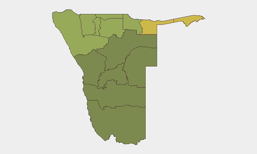
Situation Summary
Namibia remains a low-threat environment globally (rank #110, composite score 14) with no tracked major security incidents in the past 24–48 hours. Recent open-source reporting confirms localized violent crime in urban centers (Windhoek, Walvis Bay, Grootfontein) and a fatal road-traffic collision on the B1 trunk corridor, but no large-scale civil unrest, militant activity, or infrastructure attacks. The northern border regions (Zambezi, Kavango East/West) continue to carry elevated risk profiles relative to the national baseline, driven by cross-border movement and resource-competition pressures.
Key Developments
- Fatal minibus–bakkie collision, B1 road south of Otjiwarongo (Otjozondjupa Region), 31 August 2026: Four fatalities reported in head-on crash on main north–south trunk route; ongoing police investigation and potential temporary road congestion.
- Three weekend murders reported across Windhoek, Grootfontein, and Walvis Bay (29–31 August 2026): NamPol crime digest (31 August) documents murder cases including a 22-year-old fatality on Willie Gulubane Street, Katutura, Windhoek; investigations ongoing in all three locations.
- Three suspected suicides reported across ||Kharas, Kavango East, and Kunene regions (weekend prior to 31 August 2026): Police report (31 August) includes death of 14-year-old at Otjivatwa village, Kunene; localized incident but indicative of community stress.
- Junior National Council session, Windhoek (31 August–1 September 2026): Routine civic event with 42 high-school delegates; absence of reported disruption or protest is a weak indicator against acute political tension in the capital during this period.
- No confirmed reports of large-scale protests, riots, or coordinated militant activity in the 24–48 hour window: Limited open-source visibility makes absence of major incidents a qualified assessment only; minor local incidents may remain unreported.
Highest-Risk Areas
Zambezi Region (risk 62–68) and Kavango East/West (risk 58–62) drive the national sub-national risk profile and merit focused duty-of-care attention. These northern and northeastern jurisdictions experience higher rates of cross-border movement, illicit resource trafficking, and localized armed-group activity linked to regional spillover from Angola and the Democratic Republic of Congo. Kunene Region (risk 52) similarly reflects border-proximity vulnerabilities. In contrast, southern and coastal regions (Hardap, Omaheke, Erongo at risk 25–32) present materially lower threat surfaces and are suitable for standard travel and operational protocols.
How GeoBit Would Assist
Corporate security teams should deploy AOI Monitoring & Early Warning on Zambezi, Kavango East/West, and Kunene regions to detect cross-border movement, civil unrest, or resource-related violence before impact on staff or assets. Conflict & Military mapping and Network & Actor Analysis capabilities enable tracking of armed-group presence and trafficking networks in border zones. Routing & Network Analysis supports real-time rerouting of personnel and supply chains away from high-incident corridors (e.g., B1 trunk road during investigations) and identifies safer alternative transit routes, while Intel Sweep and X/Twitter OSINT maintain continuous horizon scanning for emerging local incidents not yet reflected in formal crime reporting.
7-Day Outlook
No major security escalation is forecast for the next seven days based on current open-source signals. Localized violent crime and road-safety incidents are likely to continue at baseline levels; police investigations into the weekend murders and the B1 collision may generate intermittent traffic delays. Northern border regions should remain under persistent monitoring for any uptick in cross-border activity or spillover from regional tensions.
Highest-Risk Areas — Ranked
| # | State / Region | Risk |
|---|---|---|
| 1 | Zambezi | 68 |
| 2 | Kavango East | 62 |
| 3 | Kavango West | 58 |
| 4 | Kunene Region | 52 |
| 5 | Oshikoto | 48 |
| 6 | Ohangwena | 45 |
| 7 | Omusati | 42 |
| 8 | Oshana | 40 |
| 9 | Otjozondjupa | 35 |
| 10 | Erongo Region | 32 |
| 11 | Hardap | 28 |
| 12 | Omaheke | 25 |
Sources
Previous Daily Briefs
A new Namibia brief is written every day — each with its own risk map and downloadable CSV. Here's the last week; use the calendar to go further back.
- August 30, 2026
- August 28, 2026
- August 25, 2026
- August 23, 2026
- August 21, 2026
- August 19, 2026
- August 17, 2026
📅 Browse every day by calendar →
Highlighted days have a brief. Tap a day for that day's map & analysis, or “csv” for that day's dataset ($5).
Atlas — our AI intelligence desk — emails them this snapshot personally. Nothing else, no list.