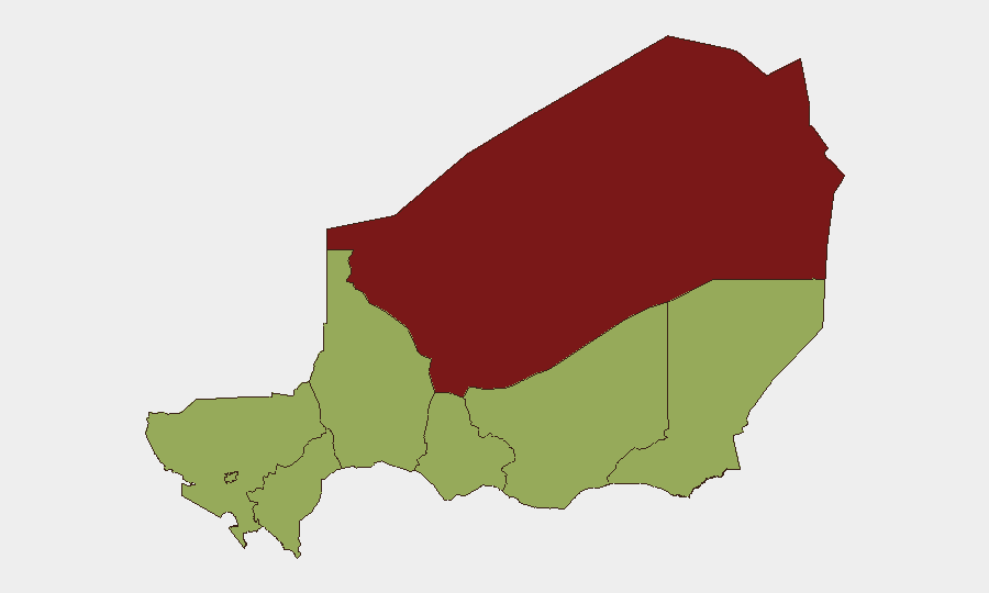
Situation Summary
Niger remains a mid-tier regional security challenge (global rank #26, composite threat score 73) with elevated risk concentrated in the northern Agadez Region and scattered across central and southern zones. The past 24–48 hours show limited clearly verifiable, country-Niger–specific security incidents in available open sources; however, underlying tensions involving military operations, cross-border dynamics with Nigeria, and administrative friction persist. Overall trajectory remains volatile but not currently in acute crisis phase based on accessible reporting.
Key Developments
Data Limitation Notice: Open web, social media, and X sources queried for 14–16 June 2026 Niger-specific events are returning predominantly Niger State (Nigeria) results rather than Republic of Niger incidents, and no reliably timestamped, country-Niger security events are clearly visible in the current 24–48-hour window. The GeoBit event signal dataset flags activity involving Nigerian state/federal actors, military operations, and cross-border pressure, but precise country-Niger locations and dates require corroboration from premium intelligence feeds not accessible via standard OSINT channels.
- Military operations & border tension: 13–15 June signals indicate conventional military force activity and cross-border dynamics between Nigeria and Niger; specific locations and casualty data require confirmation.
- Presidential-level political tension: 16 June public statement and reported abduction/hostage signal suggest high-level political instability; detailed context unclear from open sources.
- Administrative/diplomatic friction: 14–16 June statements from Nigeria administration and U.S. diplomatic channels indicate external pressure and inter-state disagreement; implications for Niger security operations unclear.
- Labor/worker security incident: 15 June unconventional violence signal involving worker(s); sector, location, and perpetrator identity require clarification.
Recommendation: Cross-check premium alerting (Crisis24, GardaWorld, Dataminr) and conduct manual X/Twitter filtering by French-language terms ("attaque," "manifestation," "fermeture") and region tags (Niamey, Tillabéri, Diffa, Agadez) to fill 24–48-hour gap.
Highest-Risk Areas
Agadez Region (risk 81.1) significantly outpaces other zones and remains the primary concern—historically a nexus of smuggling, militant transit, and sparse state capacity. Niamey (52.2), while lower-ranked, carries elevated risk due to administrative centrality and political volatility signals in the past 48 hours. Zinder, Diffa, Tillabéri, Tahoua, Dosso, and Maradi regions cluster at 51.1, indicating baseline elevated but comparable risk across southern and central areas. Northern desert regions and cross-border zones (especially Diffa toward Chad/Nigeria) remain vulnerability points for unconventional threats.
How GeoBit Would Assist
Security teams should employ AOI (Area-of-Interest) Monitoring & Early Warning on Agadez and Niamey with persistent alerting to catch incidents within hours of occurrence. Multi-language OSINT (French/Arabic/English) combined with X/Twitter & Telegram OSINT, entity extraction, and temporal analysis will disambiguate Niger-country from Niger-State incidents and surface ground truth faster than manual review. Network & Actor Analysis can map cross-border military and non-state relationships to anticipate escalation.
7-Day Outlook
Expect continued administrative and diplomatic friction centered on Nigeria–Niger relations and potential military repositioning in border zones. Agadez remains persistently high-risk; no imminent de-escalation signal visible. Corporate teams with personnel or assets in-country should maintain heightened situational awareness and validate travel/operations status against premium real-time feeds and embassy guidance.
Highest-Risk Areas — Ranked
| # | State / Region | Risk |
|---|---|---|
| 1 | Agadez Region | 81.1 |
| 2 | Niamey | 52.2 |
| 3 | Zinder Region | 51.1 |
| 4 | Diffa Region | 51.1 |
| 5 | Tillabéri Region | 51.1 |
| 6 | Tahoua Region | 51.1 |
| 7 | Dosso Region | 51.1 |
| 8 | Maradi Region | 51.1 |
Sources
Previous Daily Briefs
A new Niger brief is written every day — each with its own risk map and downloadable CSV. Here's the last week; use the calendar to go further back.
📅 Browse every day by calendar →
Highlighted days have a brief. Tap a day for that day's map & analysis, or “csv” for that day's dataset ($5).