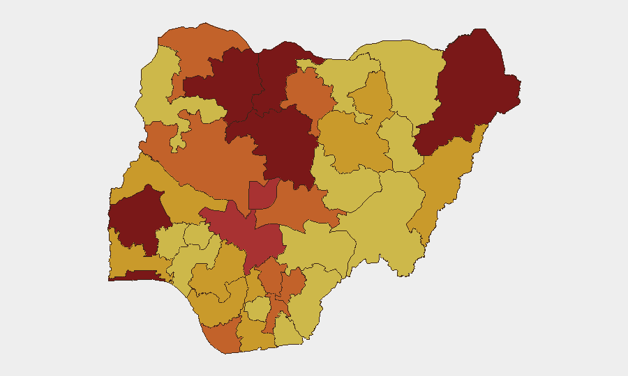
Situation Summary
Nigeria remains the third-highest-threat country globally, driven by sustained insurgent and bandit operations across northern and central states, with 479 tracked security events recorded. The last 48 hours have seen a marked uptick in incident density—11+ confirmed kidnappings, armed clashes, and military operations—alongside emerging civil unrest triggered by a nationwide #EndBadGovernance strike call. The operational tempo and breadth of actor groups (Boko Haram, armed bandits, criminal networks) indicate no near-term de-escalation; corporate and institutional assets remain exposed across multiple threat vectors.
Key Developments
- Mandara Mountains, Borno State (June 13–14): Nigerian military conducted a large-scale hostage-rescue operation, freeing approximately 360 Boko Haram abductees; two children reported deceased in captivity prior to rescue, confirming active detention infrastructure and intensive military pressure in this key insurgency zone.
- Kogi State (June 13–14): Armed bandit clashes with security forces resulted in four deaths; incident confirms sustained bandit operational presence and elevated risk for transit and logistics along affected routes.
- Plateau State (June 13–14): Military interdicted an attempted abduction of a pastor and spouse, signaling continued targeting of religious and community leaders despite ongoing security operations.
- Nationwide strike call (June 13–14, announced Abuja): The #EndBadGovernance Movement issued a 48-hour nationwide strike and protest demand over insecurity, kidnappings, and security-sector accountability; organizers are seeking labour-union participation, with significant disruption risk to commerce, travel, and service continuity.
- Ogun State student communities (June 13–14): The National Association of Nigerian Students (NANS) issued a 48-hour ultimatum to state authorities following multiple robbery attacks on student areas; escalatory action warning raises risk around tertiary-institution clusters.
- Cyber campaign (June 13, unconfirmed): Threat actor "infernaliis" reported data-exfiltration activity targeting Mustard.ng (FinTech), MCCHST Funtua (Katsina State, health college), and FGGC Owerri (Imo State, federal girls' college); incidents remain unverified but flag education and financial-services sectors for heightened cyber vigilance.
- Multi-state incident surge (June 11–14): Security trackers documented 11+ kidnap-for-ransom and armed incidents across multiple northern and central states within a single 24-hour cycle, reflecting sustained high operational tempo.
Highest-Risk Areas
Borno, Katsina, and Oyo States (risk scores 100, 89.2, and 86.6 respectively) remain the primary drivers of national threat, with Borno dominated by Boko Haram and military counter-operations, Katsina by bandit-kidnapping networks, and Oyo by urban crime and trafficking. Lagos, Kaduna, and the Federal Capital Territory (scores 85.2–78.1) present secondary but significant risk tied to armed robbery, pipeline vandalism, and governance instability. The clustering of risk in the North West and North Central zones reflects the geographic concentration of insurgent and criminal-network activity; southern states (Bayelsa, Imo) carry secondary cyber and maritime risk.
How GeoBit Would Assist
Security teams should deploy AOI Monitoring & Early Warning on Borno, Katsina, and Oyo States to receive real-time alerts on new kidnap, military, or protest activity. Routing & Network Analysis enables identification of safe corridors and alternate logistics routes avoiding high-incident zones. Intel Sweep and multi-language OSINT (X, Telegram, YouTube) provide continuous monitoring of strike-movement coordination, bandit communications, and cyber-threat-actor claims, supporting decision-making on facility lockdown, staff movement, and supply-chain adjustments.
7-Day Outlook
The 48-hour strike window (mid-June 16 onward) is likely to disrupt transport, banking, and fuel distribution, compounding kidnap-for-ransom risk on intercity routes. Boko Haram and bandit groups historically exploit strike-driven security-force redeployment; expect elevated incident probability in Borno, Katsina, and Kaduna through mid-week. Civil unrest and security operations may persist beyond the formal strike period if demands remain unaddressed.
Highest-Risk Areas — Ranked
| # | State / Region | Risk |
|---|---|---|
| 1 | Borno State | 100 |
| 2 | Katsina State | 89.2 |
| 3 | Oyo State | 86.6 |
| 4 | Lagos State | 85.2 |
| 5 | Kaduna State | 84.4 |
| 6 | Zamfara State | 80.5 |
| 7 | Federal Capital Territory | 78.1 |
| 8 | Kogi State | 76.2 |
| 9 | Bayelsa State | 75.4 |
| 10 | Sokoto State | 74.9 |
| 11 | Nasarawa State | 74.9 |
| 12 | Kano State | 74.5 |
Sources
Previous Daily Briefs
A new Nigeria brief is written every day — each with its own risk map and downloadable CSV. Here's the last week; use the calendar to go further back.
📅 Browse every day by calendar →
Highlighted days have a brief. Tap a day for that day's map & analysis, or “csv” for that day's dataset ($5).