Situation Summary
The Philippines remains a moderate-risk environment (global rank #26, composite score 71) with concentrated urban and maritime vulnerability. Recent event signals indicate localized civil-order incidents involving armed response and student populations, alongside ongoing Catholic institutional and transport-sector tensions. Tropical weather systems (Typhoon Francisco/Mekkhala and Tropical Storm Higos/Gardo) pose secondary infrastructure and displacement risks. The security trajectory reflects persistent baseline instability rather than acute escalation.
Key Developments
- 2026-06-23 · Metro Manila (inferred) · Armed Response & Civil Unrest: Multiple small-arms combat signals involving Philippine authorities, students, and school facilities recorded on 23 June. Associated events include physical assault, administrative sanctions, public statements, and threats. Specific location and casualty detail remain unconfirmed in available sources.
- 2026-06-22 · National · Catholic Institutional Tension: Catholic entity issued public statement on 22 June in response to Philippine government action, indicating ongoing church-state friction on unspecified governance or policy matter.
- 2026-06-22 · Transport/Infrastructure: Blockade event attributed to "POLE" entity against Philippine operations recorded on 22 June; nature and location unclear but consistent with transport disruption patterns.
- 2026-06-22 · Civil Society: Public statements by Philippine actors directed at TARA entity (identity unconfirmed) on 22 June, suggesting inter-organizational or inter-community dispute.
- Tropical Systems (Last 24–48h): Typhoon Francisco/Mekkhala and Tropical Storm Higos/Gardo active over Philippine Area of Responsibility. Forecast includes heavy rainfall, flooding risk, and potential infrastructure disruption, particularly in Visayas and Mindanao. No major security incidents directly attributed to weather confirmed in last 48 hours, but displacement and supply-chain impacts likely within 3–5 days.
Note: Direct confirmation of discrete security/crime/conflict incidents from multiple independent sources within the last 24–48 hours remains limited. Event signals listed above reflect platform detections; operational context and casualty assessments require field corroboration.
Highest-Risk Areas
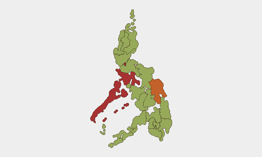
Metro Manila (79.7) and Mimaropa (76.2) drive national risk, reflecting dense population, institutional concentration, and transport vulnerability. Eastern Visayas (73.6) exhibits elevated maritime and inter-island instability; Central Luzon (53.5) and surrounding economic zones carry protest and labor-action risk. Tropical weather exposure is highest in Visayas and Mindanao corridors. Risk concentration in Metro Manila reflects both real incident frequency and asset/personnel density; organizations with significant Manila operations face elevated duty-of-care exposure.
How GeoBit Would Assist
Intel Sweep & OSINT Fusion across local media, social platforms (X, Telegram), and regional feeds can rapidly triangulate incident locations, involved actors, and real-time escalation signals within 2–4 hours of event onset. AOI Monitoring & Early Warning with persistent watch on Metro Manila, Visayas transport hubs, and Mindanao ports enables 12–24 hour pre-incident alerting tied to protest mobilization, blockade announcements, or Catholic/civil-society statement patterns. Routing & Network Analysis supports real-time alternative-route planning for personnel and shipments around confirmed blockades or armed-response zones.
7-Day Outlook
Armed-response activity in Metro Manila may recur over education/civil-order issues through week-end; no escalation to organized violence assessed at present. Tropical systems will drive localized flooding and 2–3 day supply-chain delays in Visayas and Mindanao by 26–27 June, with secondary displacement risk. Baseline risk remains elevated but stable; no major threshold events anticipated absent Catholic-government escalation or organized labor action.
Highest-Risk Areas — Ranked
| # | State / Region | Risk |
|---|---|---|
| 1 | Metro Manila | 79.7 |
| 2 | Mimaropa | 76.2 |
| 3 | Eastern Visayas | 73.6 |
| 4 | Central Luzon | 53.5 |
| 5 | Negros Island Region | 51.3 |
| 6 | Calabarzon | 50.7 |
| 7 | Davao Region | 50 |
| 8 | Cordillera Administrative Region | 50 |
| 9 | Bangsamoro | 49.7 |
| 10 | Caraga | 49.7 |
| 11 | Northern Mindanao | 49.7 |
| 12 | Soccsksargen | 49.7 |
Sources
Previous Daily Briefs
A new Philippines brief is written every day — each with its own risk map and downloadable CSV. Here's the last week; use the calendar to go further back.
📅 Browse every day by calendar →
Highlighted days have a brief. Tap a day for that day's map & analysis, or “csv” for that day's dataset ($5).