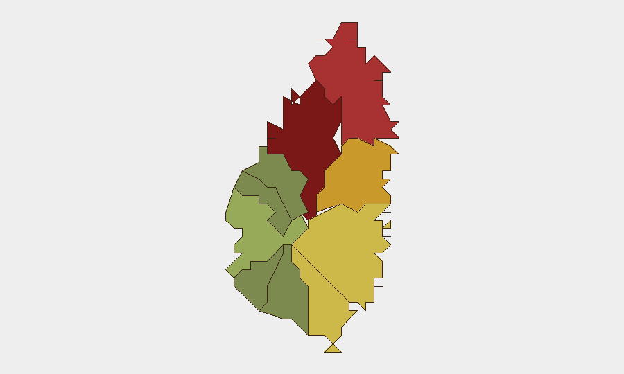
Situation Summary
Saint Lucia remains at composite threat level #83 globally with a relatively low tracked-event count, but faces persistent crime-driven security challenges concentrated in the capital and northern coastal zones. A July 10 U.S. State Department travel advisory upgrade to Level 2 ("Exercise Increased Caution") has intensified focus on armed robbery, assault, and violent incidents affecting both tourists and residents, creating a current political and economic-stability concern. Despite police reporting a decline in major crimes through early July 2026, a high-profile homicide on July 13 in Castries and ongoing investigative operations have sustained elevated threat perception and media coverage in the last 48 hours.
Key Developments
- Castries, Marigot (China Town) – July 13, 2026 (night), homicide investigation ongoing through July 16–17. A 33-year-old Saudi Arabian national was shot multiple times in a vehicle around 21:10 and pronounced dead on scene; this is the island's 42nd homicide of 2026 and has prompted formal Major Crimes Unit investigation with public appeals for information. The incident remains a primary local security concern and is actively shaping resident and business-owner perception of safety in Marigot.
- Saint Lucia nationwide – July 10, 2026 (advisory issued, implications discussed in last 48h). The U.S. Department of State upgraded travel advisory to Level 2 due to crime (armed robbery, assault, burglary, rape, violent incidents in tourist zones and resorts). This advisory remains in force and is being actively circulated by local travel-risk commentators and media as a current advisability concern.
- Castries – July 15–17, 2026 (political reaction, ongoing). Opposition parties and local media have been amplifying concerns about the U.S. advisory's economic and tourism impact, framing it as a governance and public-safety failure. This political contention over security policy is a secondary instability signal tied to the advisory and recent homicide.
- Saint Lucia (national) – data through July 10, 2026 (referenced in current debate). Royal Saint Lucia Police Force briefing indicates decline in major crimes (burglary, robbery, drug offenses, theft, sexual offenses) in H1 2026 through July 10, partially offsetting the negative travel-risk narrative but not overriding recent violent-incident concerns.
Highest-Risk Areas
Castries (risk 95) and Gros Islet (risk 78) drive the majority of national threat exposure, with Castries—particularly the Marigot district—serving as the epicenter of recent violent crime and ongoing investigative activity. Dennery (72), Vieux Fort (68), and Micoud (65) represent secondary concentration zones where armed robbery and assault remain elevated. Northern and central coastal areas account for the bulk of tourism and business activity, making crime in these zones directly relevant to duty-of-care exposure for corporate personnel and visitors; southern and inland districts (Laborie, Choiseul, Canaries) show significantly lower composite risk.
How GeoBit Would Assist
Security teams would employ AOI Monitoring & Early Warning to track Castries, Gros Islet, and Marigot for emerging violent-crime clusters and police activity; Intel Sweep and OSINT fusion to correlate local media, police bulletins, and social-media signals to identify emerging threats before they affect personnel; and Routing & Network Analysis to develop alternative safe routes and zone avoidance for staff movement in high-risk districts. Real-time sentiment and temporal analysis of local news and social channels would provide early signals of political instability or public-order deterioration.
7-Day Outlook
The homicide investigation and U.S. travel advisory are likely to remain active media and political focal points through early August, sustaining heightened perception of risk even as underlying crime statistics may show modest improvement. Carnival preparations and holiday-season foot traffic may increase both opportunity for petty crime and police presence; no major escalation in violence or political instability is indicated in the current trajectory, but monitoring of Marigot-area crime and political messaging remains essential.
Highest-Risk Areas — Ranked
| # | State / Region | Risk |
|---|---|---|
| 1 | Castries | 95 |
| 2 | Gros Islet | 78 |
| 3 | Dennery | 72 |
| 4 | Vieux Fort | 68 |
| 5 | Micoud | 65 |
| 6 | Soufrière | 42 |
| 7 | Laborie | 38 |
| 8 | Choiseul | 35 |
| 9 | Anse La Raye | 28 |
| 10 | Canaries | 12 |
Sources
Previous Daily Briefs
A new Saint Lucia brief is written every day — each with its own risk map and downloadable CSV. Here's the last week; use the calendar to go further back.
📅 Browse every day by calendar →
Highlighted days have a brief. Tap a day for that day's map & analysis, or “csv” for that day's dataset ($5).
Atlas — our AI intelligence desk — emails them this snapshot personally. Nothing else, no list.