Situation Summary
Samoa remains a low-threat environment with no acute security incidents detected in the last 24–48 hours. The principal near-term risks are health-related (dengue outbreak straining healthcare capacity), climate-related (El Niño onset reducing water and power availability), and baseline crime exposure in urban centres, particularly Apia. Regional diplomatic attention is focused on China's 6 July missile test in the Pacific, though no direct territorial threat to Samoa has been identified.
Key Developments
- Samoa Islands Region, 11 July 2026 – Magnitude 4.8 offshore earthquake recorded with no reported damage, casualties, or tsunami threat to populated areas.
- Nationwide, 11–13 July 2026 – Open-source monitoring confirms no verifiable crime, civil-order, or public-safety incidents affecting corporate or expatriate operations in the last 48 hours.
- Nationwide, current as of 13 July 2026 – Samoa's Ministry of Health has declared a dengue outbreak; Australian Smartraveller advisory notes healthcare system capacity constraints and increased risk to travelers, requiring mosquito precautions and awareness of limited emergency-response resources.
- Nationwide, 9 July 2026 – Samoa Meteorology Division confirmed El Niño conditions have developed, warning of below-normal rainfall, elevated temperatures, drought risk, reduced hydropower generation, and increased wildfire risk over coming months.
- Apia, ongoing – U.S. travel advisories (reviewed 11–13 July 2026) reiterate persistent baseline crime exposure: petty theft, robbery, and occasional violent assault, including sexual assault, particularly in downtown bars and restaurants; emergency services remain under-resourced.
- Government statement, Apia, current in regional discourse – Samoa's government noted concern over China's 6 July intercontinental ballistic missile test into the Pacific, while affirming the test was conducted in line with international law and not directed at any specific country.
Highest-Risk Areas
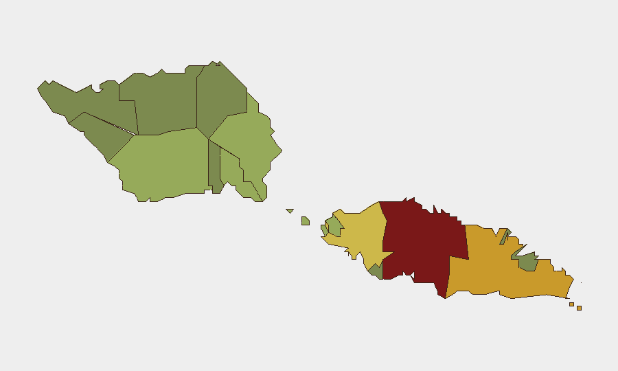
Tuamasaga (risk 85) and Ātua (risk 71) drive the majority of tracked risk events and account for the steepest composite scores. Tuamasaga encompasses Apia and surrounding urban zones, where baseline crime concentration (theft, assault, under-resourced policing) and health-system vulnerability (dengue caseload) are most acute. Ātua's elevated score reflects secondary urban density and infrastructure interdependencies. The remaining nine districts show progressively lower risk; outer and rural regions pose negligible security exposure to corporate operations.
How GeoBit Would Assist
Security teams should deploy AOI Monitoring & Early Warning on Tuamasaga and Ātua to detect spikes in crime-related incident reporting, social-media signals of unrest, or health-system failures. Intel Sweep and multi-language OSINT (including regional news feeds and local social channels) enable continuous detection of emerging public-order, health, or infrastructure events that could affect duty-of-care or business continuity. Environmental & Health intelligence combined with Routing & Network Analysis allows rapid assessment of dengue and El Niño impacts on staff mobility, healthcare access, and supply-chain resilience, with alternative-route planning for critical operations.
7-Day Outlook
No acute security deterioration is anticipated over the next seven days. Health and climate risks will remain the primary drivers of operational friction: dengue caseloads may continue to rise, and El Niño-related water and power constraints may begin to affect infrastructure. Diplomatic attention on the China missile test is unlikely to translate into direct security incidents in Samoa, though regional strategic monitoring remains warranted.
Highest-Risk Areas — Ranked
| # | State / Region | Risk |
|---|---|---|
| 1 | Tuamasaga | 85 |
| 2 | Ātua | 71 |
| 3 | Aʻana | 62 |
| 4 | Aiga-i-le-Tai | 55 |
| 5 | Faʻasaleleaga | 48 |
| 6 | Palauli | 42 |
| 7 | Satupaʻitea | 38 |
| 8 | Gagaʻemauga | 35 |
| 9 | Gagaʻifomauga | 32 |
| 10 | Vaisigano | 28 |
| 11 | Vaʻa-o-Fonoti | 23 |
Sources
Previous Daily Briefs
A new Samoa brief is written every day — each with its own risk map and downloadable CSV. Here's the last week; use the calendar to go further back.
📅 Browse every day by calendar →
Highlighted days have a brief. Tap a day for that day's map & analysis, or “csv” for that day's dataset ($5).
Atlas — our AI intelligence desk — emails them this snapshot personally. Nothing else, no list.