Situation Summary
San Marino remains a low-threat jurisdiction with a composite threat score of 3 and no tracked security events in the current assessment window. The only active security-relevant development in the last 24–48 hours is a yellow-level meteorological alert (17 Aug) for thunderstorms across the territory, which poses limited disruption risk. No civil unrest, political instability, organized crime escalation, or infrastructure failures are evident within San Marino's borders as of 18 August 2026.
Key Developments
- Meteorological Alert – San Marino (17 Aug 2026, 00:00–00:00 on 18 Aug). Unione Volontariato Protezione Civile San Marino issued a yellow-code weather alert for strong thunderstorms, with risk of localized landslides, stream overflow, and urban flooding. No casualties or significant damage reported; standard seasonal weather event with potential for minor road and travel disruption.
- San Marino–Flagged Vessel Strike – Black Sea, off Novorossiysk (14–15 Aug 2026, reported 15–16 Aug). A bulk carrier registered under San Marino's flag sustained hits from two unmanned aerial systems near Novorossiysk port; two Syrian crew members were hospitalized with non-life-threatening injuries. Incident reflects broader Black Sea maritime conflict risk but occurs outside San Marino's territory and does not indicate terrestrial threat escalation.
- Routine Traffic and Narcotics Report – San Marino (15 Aug 2026). A 23-year-old failed to stop at a police checkpoint, subsequently tested positive for alcohol and narcotics, with a small quantity of hashish discovered during a home search. Individual was reported to judicial authorities without arrest; classified as routine policing with no indication of organized crime activity or civil unrest.
Highest-Risk Areas
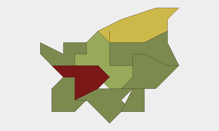
Città di San Marino (risk score 85) and Serravalle (68) account for the majority of the country's composite risk and merit proportional monitoring focus, though both scores reflect normal urban density and transient populations rather than acute threats. Borgo Maggiore (52), Fiorentino (32), and Domagnano (28) represent secondary risk nodes; the remaining five micro-districts fall below 25 and are categorized as minimal-risk. Risk concentration in the two largest settlements is typical for a 61-square-kilometre microstate with ~34,000 inhabitants and reflects population distribution, not instability.
How GeoBit Would Assist
Organizations with personnel or assets in San Marino should employ AOI Monitoring & Early Warning to track Città di San Marino and Serravalle for any departure from routine civil or commercial activity, and multi-language web search and social-media OSINT (X/Twitter, Telegram) to detect civil unrest or protest activity at earliest formation. For those with maritime or supply-chain exposure via San Marino flag registry, Maritime & Aviation tracking and conflict-zone routing analysis provide real-time visibility into vessel positions, incident patterns in the Black Sea, and alternative routing options to mitigate maritime risk.
7-Day Outlook
The yellow weather alert is expected to clear by 18 August; no weather or civil escalation is forecast for the week ahead. San Marino's threat posture is expected to remain stable and low, barring unforeseen regional developments (e.g., spillover from Mediterranean or Central European instability). Duty-of-care teams should maintain baseline monitoring but require no elevated alert posture.
Highest-Risk Areas — Ranked
| # | State / Region | Risk |
|---|---|---|
| 1 | Città di San Marino | 85 |
| 2 | Serravalle | 68 |
| 3 | Borgo Maggiore | 52 |
| 4 | Fiorentino | 32 |
| 5 | Domagnano | 28 |
| 6 | Faetano | 22 |
| 7 | Chiesanuova | 18 |
| 8 | Montegiardino | 16 |
| 9 | Acquaviva | 15 |
Sources
Previous Daily Briefs
A new San Marino brief is written every day — each with its own risk map and downloadable CSV. Here's the last week; use the calendar to go further back.
- August 16, 2026
- August 13, 2026
- August 11, 2026
- August 9, 2026
- August 7, 2026
- August 5, 2026
- August 4, 2026
📅 Browse every day by calendar →
Highlighted days have a brief. Tap a day for that day's map & analysis, or “csv” for that day's dataset ($5).
Atlas — our AI intelligence desk — emails them this snapshot personally. Nothing else, no list.