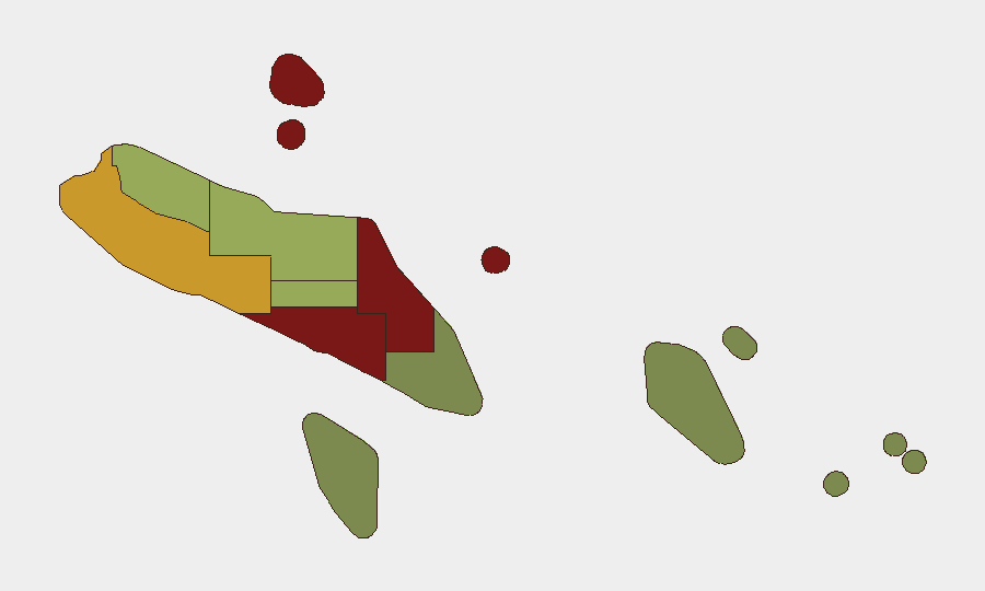
Situation Summary
Solomon Islands remains a low-intensity threat environment with a composite global threat ranking of #133 and no tracked security events in the current reporting window. However, significant sub-national variance exists: Honiara and Guadalcanal provinces carry elevated risk scores (92 and 88 respectively), driven by historical gang violence, property crime, and infrastructure vulnerabilities in the capital region. The broader security picture is stable but fragile, with governance transitions and uneven institutional capacity creating pockets of elevated concern.
Key Developments
No discrete security, conflict, civil-unrest, crime, or infrastructure incidents were verified in Solomon Islands during the 24–48 hour window ending 2 July 2026.
Background context (outside current window):
- May 2026: Prime Minister Jeremiah Manele was removed by parliamentary no-confidence vote, creating a period of political uncertainty. No follow-on instability or civil unrest was reported.
- 1 July 2026: Auditor General's office launched a Community Participatory Audit programme in Honiara—a governance initiative to improve public oversight, not a security event.
- Regional: Solomon Islands and Fiji reportedly signed a bilateral security pact (reported 1 July), but no incident or disruption within Solomon Islands territory was indicated.
Highest-Risk Areas
Honiara (risk 92) and Guadalcanal (risk 88) together account for the majority of measurable security risk in the country. Both provinces are characterized by concentrated population density, competition for informal employment, limited police presence outside the capital, and episodic gang-related property crime and interpersonal violence. Malaita (risk 85) and Western Province (risk 72) represent secondary risk zones, reflecting historical communal tensions and maritime crime exposure. Outer provinces (Temotu, Rennell and Bellona, Makira-Ulawa) carry substantially lower risk scores and remain relatively stable.
How GeoBit Would Assist
A corporate security team with personnel or assets in Solomon Islands should deploy AOI Monitoring & Early Warning on Honiara and Guadalcanal to detect emerging civil unrest, gang activity, or infrastructure disruption before operational impact. Intel Sweep and OSINT fusion (combining X/Telegram OSINT, local news feeds, and multi-language search) would provide continuous visibility of political developments, shipping/aviation delays, and law-enforcement operations that affect movement and asset security. Risk & Threat Assessment capabilities would enable quarterly re-baselining of provincial risk profiles as political transitions settle and community stability indicators shift.
7-Day Outlook
No acute security deterioration is forecast for the next seven days. The political transition following the May no-confidence vote appears to have stabilized without triggering widespread unrest. Routine crime and property-security risks in Honiara will persist; teams should maintain standard duty-of-care protocols (awareness briefings, secure accommodation, verified transport). The Fiji–Solomon Islands security pact may enhance regional maritime and counter-terrorism coordination over coming weeks, but no immediate operational impact on commercial or corporate activity is anticipated.
Highest-Risk Areas — Ranked
| # | State / Region | Risk |
|---|---|---|
| 1 | Honiara | 92 |
| 2 | Guadalcanal | 88 |
| 3 | Malaita | 85 |
| 4 | Western | 72 |
| 5 | Choiseul | 58 |
| 6 | Isabel | 52 |
| 7 | Central Province | 48 |
| 8 | Makira-Ulawa | 38 |
| 9 | Rennell and Bellona | 22 |
| 10 | Temotu | 18 |
Sources
Previous Daily Briefs
A new Solomon Islands brief is written every day — each with its own risk map and downloadable CSV. Here's the last week; use the calendar to go further back.
📅 Browse every day by calendar →
Highlighted days have a brief. Tap a day for that day's map & analysis, or “csv” for that day's dataset ($5).