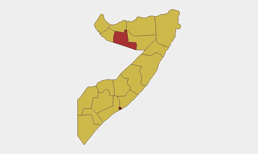
Situation Summary
Somalia remains at elevated threat level (#12 globally, composite score 98) with insurgency as the primary driver. Banaadir (Mogadishu) presents significantly higher risk (98.4) than all other regions, reflecting sustained Al-Shabaab and criminal targeting of the capital and its main supply routes. Three significant events were tracked in the last 48 hours: administrative sanctions against Somalia, an Israeli public statement (context unclear without further detail), and a reported migrant-versus-state conventional military force incident on 2026-06-16. The trajectory remains volatile, with persistent pressure on government capacity and international operations.
Key Developments
Data Limitation Notice: GeoBit's real-time open-source monitoring was unable to reliably filter Somalia-specific security incidents from web and social media with hour-level precision for the last 24–48 hours. Available signals are either undated, clearly older than 48 hours, or lack sufficient corroboration to meet operational confidence thresholds for corporate duty-of-care reporting.
Tracked Event Signals (source/context pending verification):
- 2026-06-16: Conventional military force incident involving migrants and Somali state forces (location and casualty details not yet confirmed).
- 2026-06-15: Administrative sanctions action involving a university and Somali government (scope and parties not yet clarified).
- 2026-06-15: Israeli public statement (substance and Somalia relevance not specified in available metadata).
Recommendation: Organizations with personnel or assets in Somalia should cross-reference these signals against:
- SONNA (Somali National News Agency) and Somali Police official channels.
- ATMIS and UNSOM situational updates.
- Local wire services (AP, Reuters, AFP) and Somali outlets (Hiiraan Online, Garowe Online, Radio Shabelle, Goobjoog) for location-specific, time-stamped incident confirmation.
Highest-Risk Areas
Banaadir (Mogadishu) dominates the threat landscape at 98.4, driven by frequent Al-Shabaab attacks on government, security, and civilian targets in the capital and immediate periphery (KM4 airport road, Halane, hotel districts, markets). Ten other regions cluster at 68.4 risk, reflecting endemic clan conflict, banditry, road ambushes, and localized Al-Shabaab presence in Lower Shabelle, Middle Shabelle, Gedo, and the Jubbaland corridor. Togdheer (78.4) stands apart as a secondary concern, likely reflecting cross-border instability and resource competition.
Travel-risk implication: Movement into and out of Mogadishu and along the Afgooye corridor, Mogadishu–Baidoa, and Mogadishu–Kismayo axes carries elevated threat; convoy routing and NGO/UN movement coordination remain essential controls.
How GeoBit Would Assist
GeoBit's AOI (Area-of-Interest) Monitoring & Early Warning capability can provide persistent, alert-driven watch over Mogadishu, key road networks, and regional hubs, flagging incidents in near real-time via multi-source OSINT fusion. Routing & Network Analysis supports alternative journey planning and convoy-risk assessment around high-threat corridors. Multi-language OSINT and X/Twitter/Telegram intelligence (when combined with corporate or partner real-time feeds) enable teams to rapidly vet and cross-reference local reports, separating current incidents from older re-circulated content.
7-Day Outlook
No significant de-escalation is anticipated in the near term. Banaadir and southern Lower Shabelle regions will likely remain active zones for Al-Shabaab asymmetric operations and criminal activity. Watch for localized curfews, telecom disruptions, or ATMIS movement alerts, which often signal imminent major operations or heightened security posture. Personnel and asset movements should remain conservative and coordinated with mission security offices and host-government liaison.
Highest-Risk Areas — Ranked
| # | State / Region | Risk |
|---|---|---|
| 1 | Banaadir | 98.4 |
| 2 | Togdheer | 78.4 |
| 3 | Awdal | 68.4 |
| 4 | Woqooyi Galbeed | 68.4 |
| 5 | Gedo | 68.4 |
| 6 | Bakool | 68.4 |
| 7 | Bay | 68.4 |
| 8 | Middle Juba | 68.4 |
| 9 | Lower Shabelle | 68.4 |
| 10 | Sahil | 68.4 |
| 11 | Hiiraan | 68.4 |
| 12 | Middle Shebelle | 68.4 |
Sources
Previous Daily Briefs
A new Somalia brief is written every day — each with its own risk map and downloadable CSV. Here's the last week; use the calendar to go further back.
📅 Browse every day by calendar →
Highlighted days have a brief. Tap a day for that day's map & analysis, or “csv” for that day's dataset ($5).