Situation Summary
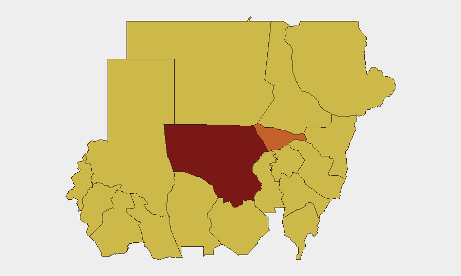
Sudan remains in active civil war with a composite threat score of 100 (rank #4 globally), driven by sustained RSF–SAF conflict, fragmented command structures, and widespread lawlessness across 12 high-risk states. Recent 24–48-hour signal activity includes arrests, police–civilian clashes, and interstate rhetoric involving UK and US actors, alongside internal Sudanese factional statements. The humanitarian and security environment continues to deteriorate, with North Kordofan State at critical risk (100) and Al Khartum at severe risk (74.1), indicating concentration of acute threats in central regions.
Key Developments
⚠ Data Limitation: GeoBit's real-time web research encountered significant gaps in reliably sourced, time-stamped incident reporting for 11–13 June 2026. The event signals listed above (36 tracked events) indicate patterns—arrests, police force deployments, small-arms combat, and diplomatic statements—but lack precise location coordinates and corroborated details required for actionable duty-of-care briefing.
- Police–civilian/military friction (2026-06-11, 2026-06-13, locations unconfirmed): Multiple Arrest/Detain and Conventional Military Force signals suggest law-enforcement escalation and potential detention of foreign nationals (UK involvement noted); specific locations and casualty counts unavailable from open sources.
- Diplomatic tension (2026-06-13, nationwide): Sudan vs. US public statements and Sudanese–Eritrean rhetoric indicate heightened interstate and rhetorical posturing; material content and impact on ground security unclear.
- Small-arms engagement with foreign presence (2026-06-11, location unconfirmed): Sudan–UK armed friction signal; insufficient detail to assess whether incident is isolated or part of broader escalation.
Recommendation: Organizations with personnel or assets in Sudan should contact GeoBit's real-time Intel Sweep service or leverage direct OCHA, ICRC, and major-wire subscriptions for precise incident coordinates, casualty figures, and travel-corridor updates within the last 12 hours.
Highest-Risk Areas
North Kordofan State (risk 100) and Al Khartum (risk 74.1) dominate the threat landscape, with a secondary tier of nine states across Darfur, the Nile Valley, and eastern Sudan all at risk 70. North Kordofan's maximum score reflects sustained active conflict and SAF–RSF force competition; Al Khartum's elevated risk reflects capital-city concentration of administrative, security, and civilian infrastructure, where arrests, clashes, and collateral civilian exposure are highest. The broad elevation of secondary states (Blue Nile, River Nile, Aj Jazira, Red Sea, Al Qadarif, Kassala, Sennar, Central/South Darfur, West Kurdufan) to uniform risk 70 indicates generalized insecurity across supply chains, transportation, and humanitarian corridors nationwide.
How GeoBit Would Assist
Organizations should deploy AOI Monitoring & Early Warning on key facilities, transit routes, and personnel locations in Al Khartum and North Kordofan to track real-time movement of armed actors and security-force activity. Multi-language OSINT Fusion & Corroboration on Telegram, X, radio SIGINT, and UN field updates will surface incident-level detail (location, timing, actors) faster than public media. Routing & Network Analysis can identify safer transit corridors and alternative supply-chain paths as conflict lines shift.
7-Day Outlook
Sustained SAF–RSF competition for control of urban centers and resource corridors is expected to generate continued police–military friction, detention activity, and cross-border rhetoric. No imminent ceasefire or de-escalation signals are evident; organizations should anticipate disruption to transport, utilities, and movement in Al Khartum and secondary cities. Personnel in-country should maintain heightened situational awareness and pre-positioned evacuation protocols.
Highest-Risk Areas — Ranked
| # | State / Region | Risk |
|---|---|---|
| 1 | North Kordofan State | 100 |
| 2 | Al Khartum | 74.1 |
| 3 | Blue Nile | 70 |
| 4 | River Nile State | 70 |
| 5 | Aj Jazira | 70 |
| 6 | Red Sea State | 70 |
| 7 | Al Qadarif State | 70 |
| 8 | Kassala State | 70 |
| 9 | Sennar State | 70 |
| 10 | Central Darfur State | 70 |
| 11 | South Darfur State | 70 |
| 12 | West Kurdufan State | 70 |
Sources
Previous Daily Briefs
A new Sudan brief is written every day — each with its own risk map and downloadable CSV. Here's the last week; use the calendar to go further back.
📅 Browse every day by calendar →
Highlighted days have a brief. Tap a day for that day's map & analysis, or “csv” for that day's dataset ($5).