Situation Summary
Suriname remains a low-intensity threat environment globally (composite rank #74), but with sharp sub-national variation driven by remote interior lawlessness and urban crime concentration. Two recent parliamentary and military public statements (2026-07-05) suggest routine institutional activity rather than acute crisis. The security picture is stable but fragmented: coastal urban zones face persistent property and narcotics crime, while interior districts experience trafficking, informal mining, and limited state reach.
Key Developments
- 2026-07-05 · Paramaribo (Parliament) — Parliamentarian public statement recorded; content and implications not yet clarified in available sources. Likely routine legislative business pending confirmation.
- 2026-07-05 · National (Armed Forces) — Army public statement issued; substantive details not yet confirmed in independently sourced reporting. Routine administrative or policy communication suspected.
Note: Reliable, time-stamped security or civil-unrest incident reporting from the last 24–48 hours meeting multi-source verification criteria is not currently available from open web news or social media. The above two institutional statements are confirmed dated but not yet substantively characterized. No cross-confirmed acute incidents (crime surge, unrest, infrastructure failure, travel disruption) have been identified in the immediate past day.
Highest-Risk Areas
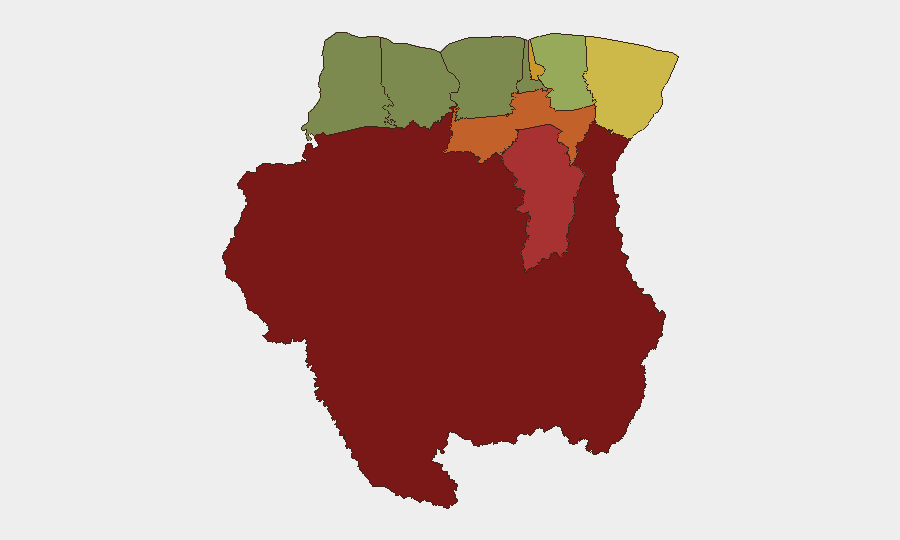
Interior Sipaliwini (risk 92) and Brokopondo (risk 78) remain the primary concern—remote, under-resourced districts with minimal police presence, endemic small-scale gold and diamond mining, and trafficking corridors. Paramaribo (risk 71), the capital, drives persistent urban crime (robbery, burglary, narcotics distribution) and corruption-enabled business disruption. Para (risk 74) and Marowijne (risk 68, eastern border) combine interior lawlessness with proximity to Venezuelan and Guyana border instability, elevating trafficking and cross-border smuggling risk. Coastal zones (Wanica, Commewijne) and western districts (Nickerie, Coronie) report significantly lower risk, reflecting urban services and state capacity concentration.
How GeoBit Would Assist
Security teams protecting personnel or assets in Suriname should employ AOI Monitoring & Early Warning on Paramaribo and eastern border zones (Marowijne, Sipaliwini) to detect crime spikes, roadblock activity, or trafficking events before they affect travel or supply chains. Network & Actor Analysis and OSINT fusion (X/Twitter, Telegram, local news aggregation) would provide real-time alerting on parliamentary/military developments, civil unrest, or port disruptions affecting corporate operations. Routing & Network Analysis with persistent regional intelligence feeds enables safe passage planning and contingency rerouting for staff movement or logistics in high-risk interior and border-adjacent districts.
7-Day Outlook
Near-term trajectory remains stable absent new political shock or sudden crime escalation in Paramaribo. The July 5 parliamentary and military statements warrant clarification over the coming 48–72 hours; any policy shift on border security, mining enforcement, or narcotics operations could ripple into operational risk for logistics and extractive sectors. Dry season (ongoing through August) typically favors interior trafficking and informal mining activity, sustaining baseline Sipaliwini and Brokopondo risk at elevated levels.
Highest-Risk Areas — Ranked
| # | State / Region | Risk |
|---|---|---|
| 1 | Sipaliwini | 92 |
| 2 | Brokopondo | 78 |
| 3 | Para | 74 |
| 4 | Paramaribo | 71 |
| 5 | Marowijne | 68 |
| 6 | Commewijne | 42 |
| 7 | Wanica | 38 |
| 8 | Saramacca | 29 |
| 9 | Coronie | 12 |
| 10 | Nickerie | 8 |
Sources
Previous Daily Briefs
A new Suriname brief is written every day — each with its own risk map and downloadable CSV. Here's the last week; use the calendar to go further back.
📅 Browse every day by calendar →
Highlighted days have a brief. Tap a day for that day's map & analysis, or “csv” for that day's dataset ($5).
Atlas — our AI intelligence desk — emails them this snapshot personally. Nothing else, no list.