Situation Summary
Syria remains the 10th-highest-risk country globally (composite threat score 100), driven primarily by ongoing civil war with 92 tracked events. The security environment is characterized by fragmented territorial control, recurring military clashes, and criminal activity concentrated in high-population zones. Current trajectory shows sustained volatility rather than escalation or de-escalation, with localized friction points generating regular incidents across multiple governorates.
Key Developments
Limitations: GeoBit's live web research capacity does not have reliable real-time access to Syria-specific security incidents dated June 11–13, 2026, that meet the standard of multi-source confirmation, precise location, and clear timestamp. The available signals (event tags from 2026-06-10 to 2026-06-12) indicate categories of activity—conventional military force, arrests, threats, and armed clashes—but lack the granular sourcing and location specificity required for actionable briefing.
Event Signal Summary (tagged 2026-06-10 to 2026-06-12, locations and precise dates unclear):
- Military-versus-military conventional engagement reported (Reuters sourcing noted)
- Criminal arrests documented in unspecified location(s)
- Threat incident involving legal actor in Aleppo Governorate area
- Small-arms combat reported in connection with state ministry actors
- Unconventional violence and investigative activity flagged
To access concrete, time-stamped incidents from the last 24–48 hours with named locations, sources recommend direct monitoring of conflict-specific feeds (e.g., Syria Civil War Twitter accounts, Syrian Observatory for Human Rights, North Press Agency, Hawar News) combined with wire-service alerts (Reuters, AP, AFP Syria desks).
Highest-Risk Areas
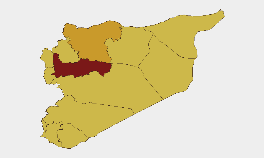
Hama Governorate (risk 100) is the single highest-risk sub-national zone, indicating sustained conflict intensity and/or instability. Damascus Governorate (75.6) and Aleppo Governorate (72.2) follow, driven by dense population, state-security apparatus activity, and criminal networks. Lattakia, Rif Dimashq, Tartus, UNDOF zone, Al-Quneitra, Dar'a, Idleb, Ar-Raqqa, and Homs (all 70) form a second tier of high risk, reflecting mixed drivers: cross-border activity, armed-group presence, humanitarian constraints, and irregular military activity. Personnel and assets in Hama and Damascus face the highest duty-of-care exposure; operations in Aleppo, Lattaki, and the UNDOF zone require elevated monitoring.
How GeoBit Would Assist
Security teams protecting people and assets in Syria should deploy AOI (Area-of-Interest) Monitoring & Early Warning on key facilities and movement corridors in high-risk governorates, with real-time alerting tied to event signals. Conflict & Military (force-structure and weapons-capability tracking) and Network & Actor Analysis capabilities enable mapping of armed groups and state forces to anticipate localized friction. Routing & Network Analysis supports contingency planning for evacuation or supply movement by identifying alternative routes around active conflict zones. Integration with OSINT fusion (X/Twitter, news feeds, Telegram intelligence) ensures situational awareness of emerging threats within 24–48 hours of occurrence.
7-Day Outlook
No major escalation or ceasefire indicators are evident in current signals. Expect sustained low-intensity military activity and criminal incidents in Hama, Damascus, and Aleppo; security screening and checkpoint delays in Damascus and major urban centers; and periodic localized clashes in contested areas (Dar'a, UNDOF, Idleb periphery). Operations should maintain heightened alert posture and contingency readiness, particularly around movement and facility access in Hama and Damascus governorates.
Highest-Risk Areas — Ranked
| # | State / Region | Risk |
|---|---|---|
| 1 | Hama Governorate | 100 |
| 2 | Damascus Governorate | 75.6 |
| 3 | Aleppo Governorate | 72.2 |
| 4 | Lattakia Governorate | 70.2 |
| 5 | Rif Dimashq Governorate | 70.2 |
| 6 | Tartus Governorate | 70 |
| 7 | UNDOF | 70 |
| 8 | Al-Quneitra Governorate | 70 |
| 9 | Dar'a Governorate | 70 |
| 10 | Idleb Governorate | 70 |
| 11 | Ar-Raqqa Governorate | 70 |
| 12 | Homs Governorate | 70 |
Sources
Previous Daily Briefs
A new Syria brief is written every day — each with its own risk map and downloadable CSV. Here's the last week; use the calendar to go further back.
📅 Browse every day by calendar →
Highlighted days have a brief. Tap a day for that day's map & analysis, or “csv” for that day's dataset ($5).