Situation Summary
Togo remains a low-to-moderate global threat environment (rank #61, composite score 21) with no verified security incidents reported in the last 24–48 hours. However, elevated structural risks persist in the north due to cross-border militant activity from Burkina Faso, and intermittent civil unrest has been documented in Lomé since early June 2025. The overall security picture is stable but regionally fragmented, with significant disparity between the low-risk maritime south and the high-threat Savanes region.
Key Developments
- No new verified security, conflict, or civil-unrest incidents confirmed in Togo during the 24–48 hours preceding 2026-07-16. Current open-source feeds, country security briefs, and official travel advisories do not record discrete dated events in this window.
- Historical backdrop (for context): Small arms combat attributed to JUNTA actors was tracked on 2026-07-16; a demonstration/rally linked to United States interests was logged on 2026-07-14. Neither has been independently confirmed as a current, active threat by corroborating open sources as of this brief.
- Savanes region remains under state of emergency (pre-dating this reporting period) due to persistent cross-border militant incursions from Burkina Faso, particularly in Kpendjal, Kpendjal Ouest, Cinkassé, and Oti prefectures. This status is structural, not incident-driven.
- Intermittent civil unrest and road blockages in Lomé continue (ongoing since early June 2025), with occasional social-media restrictions reported; no new blockade or protest event is documented in the last 24–48 hours.
- Data gaps noted in the north. Open-source coverage in remote Savanes and Kara regions remains sparse; events may occur and not be immediately visible to civilian intelligence feeds.
Highest-Risk Areas
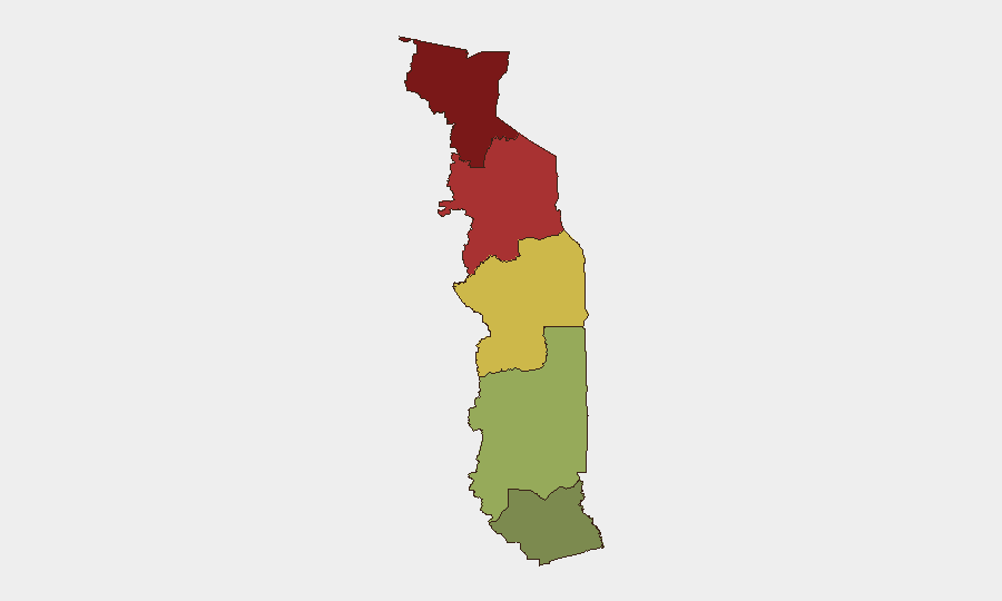
Savanes Region (risk score 92) dominates the threat landscape, driven by active cross-border militant operations from Burkina Faso and a declared state of emergency affecting six prefectures. Kara Region (score 78) faces similar but slightly lower secondary risk from the same drivers. These two regions account for the majority of Togo's security burden; by contrast, Maritime Region (score 28) and Plateaux Region (score 45) present significantly lower risk profiles. Corporate and NGO operations in Savanes should assume elevated baseline threat; those in Maritime and Plateaux can apply standard urban/rural security protocols.
How GeoBit Would Assist
Security teams monitoring Togo should employ AOI Monitoring & Early Warning with persistent watch on Savanes and Kara prefectures to detect cross-border activity or state-of-emergency escalation before it affects operations. Intel Sweep and OSINT fusion (including X/Twitter and Telegram monitoring, multi-language search, and radio SIGINT) are essential to close data gaps in remote northern zones and corroborate rumors circulating in isolated areas. Routing & Network Analysis can identify secure alternate routes if primary roads become blocked by unrest or militant activity.
7-Day Outlook
No imminent escalation is anticipated in the near term; conditions are expected to remain consistent with the current regional bifurcation (stable south, elevated-risk north). However, monitoring should intensify if cross-border Burkina Faso activity increases or if Lomé protests move beyond intermittent blockages into sustained civil unrest. Data refresh cycles of 12–24 hours are recommended for organizations with personnel or assets north of Kara.
Highest-Risk Areas — Ranked
| # | State / Region | Risk |
|---|---|---|
| 1 | Savanes Region | 92 |
| 2 | Kara Region | 78 |
| 3 | Centrale Region | 65 |
| 4 | Plateaux Region | 45 |
| 5 | Maritime Region | 28 |
Sources
Previous Daily Briefs
A new Togo brief is written every day — each with its own risk map and downloadable CSV. Here's the last week; use the calendar to go further back.
📅 Browse every day by calendar →
Highlighted days have a brief. Tap a day for that day's map & analysis, or “csv” for that day's dataset ($5).
Atlas — our AI intelligence desk — emails them this snapshot personally. Nothing else, no list.