Situation Summary
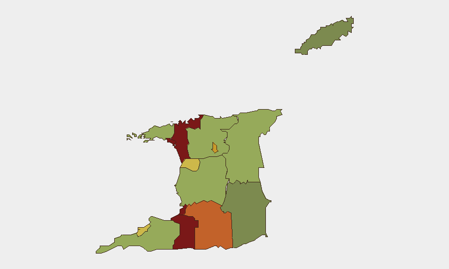
Trinidad and Tobago remains a low-threat environment globally (rank #80, composite score 15), with no tracked security incidents recorded in GeoBit's system as of 2026-06-25. However, sub-national risk is concentrated sharply in the western and central urban corridors—San Juan-Laventille, Port of Spain, and Penal-Debe—where organized crime, gang activity, and violent property crime persist. A national state of emergency remains in effect, and recent petty-to-mid-level crime (including an ATM theft attempt on 2026-06-24) continues to generate public concern despite low fatality counts.
Key Developments
- Scarborough, Tobago – 2026-06-24 (early morning): Police responded to a theft attempt targeting an ATM using a stolen backhoe. Suspects damaged the equipment and failed to breach the vault; the ATM was left detached on a public sidewalk. Security footage circulated widely on local media and social platforms, drawing public ridicule. The incident occurred during the ongoing national state of emergency. Investigation ongoing; perpetrators remain at large.
- Legal/Institutional signals (2026-06-23 to 2026-06-25): Multiple attorney-related public statements, rejections, and investigation notices populated open reporting. Signals include disputes between attorneys and police, state attorney general communications, and out-of-jurisdiction references (California, New York). Context and operational impact remain unclear from open sources; likely reflect domestic legal proceedings unrelated to physical security threats.
Highest-Risk Areas
San Juan-Laventille (risk 95), Port of Spain (88), and Penal-Debe (82) account for the bulk of sub-national threat concentration—all in the western metropolitan and central zones. Gang-affiliated violence, armed robbery, and organized property crime drive rankings in these areas; Princes Town, Arima, and Chaguanas (risks 75, 72, 68 respectively) extend the high-risk corridor southward and eastward. Eastern and southern rural areas (Sangre Grande, Couva-Tabaquite-Talparo, Siparia) show materially lower risk. Corporate assets, staff, and supply routes in or transiting the top five risk zones warrant elevated situational awareness and access controls.
How GeoBit Would Assist
Organizations with personnel or assets in Trinidad and Tobago should employ AOI Monitoring & Early Warning on high-risk zones (San Juan-Laventille, Port of Spain) to detect emerging violence, roadblocks, or protest activity in real time. Intel Sweep and X/Twitter & Telegram OSINT capabilities provide continuous local-language monitoring of gang communications, police alerts, and civil unrest signals; sentiment & temporal analysis flags escalation patterns. GIS & Spatial Analysis combined with alternative route/journey planning allows security teams to map safe transit corridors and identify choke points during state-of-emergency conditions.
7-Day Outlook
The state of emergency and concentrated gang activity in western urban zones are likely to persist without significant policy change. Petty-to-organized crime (ATM theft, armed robbery, vehicle theft) will remain the primary physical-security threat to corporate operations; political or civil unrest signals do not currently suggest imminent mass protests or destabilization. Risk posture should remain elevated in top-five risk zones; routine monitoring and standard duty-of-care protocols are sufficient for eastern and southern regions.
Highest-Risk Areas — Ranked
| # | State / Region | Risk |
|---|---|---|
| 1 | San Juan-Laventille | 95 |
| 2 | Port of Spain | 88 |
| 3 | Penal-Debe | 82 |
| 4 | San Fernando | 80 |
| 5 | Princes Town | 75 |
| 6 | Arima | 72 |
| 7 | Chaguanas | 68 |
| 8 | Point Fortin | 65 |
| 9 | Diego Martin | 58 |
| 10 | Siparia | 55 |
| 11 | Couva-Tabaquite-Talparo | 52 |
| 12 | Sangre Grande | 48 |
Sources
Previous Daily Briefs
A new Trinidad and Tobago brief is written every day — each with its own risk map and downloadable CSV. Here's the last week; use the calendar to go further back.
📅 Browse every day by calendar →
Highlighted days have a brief. Tap a day for that day's map & analysis, or “csv” for that day's dataset ($5).