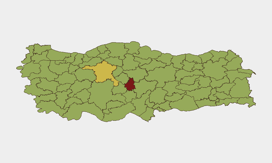
Situation Summary
Turkey remains at moderate-elevated global risk (rank #21, composite score 74), driven by a mixture of diplomatic tensions, domestic political dynamics, and regional instability. Event signals over the last 72 hours show elevated diplomatic friction, including rejection statements, disapprovals involving regional and international actors (Hyundai, Cyprus, Moscow, Israel, Iran), and multiple public statements. Web-based open-source reporting has not yielded sufficient corroborated incident detail for the last 24–48 hours to confirm specific security events, crime, infrastructure disruptions, or travel incidents; operational teams should rely on sub-national risk rankings and OSINT feeds rather than headline coverage for near-term situational awareness.
Key Developments
- Diplomatic signaling (2026-06-15 to 2026-06-18, nationwide). Multiple rejection and disapproval statements involving Turkey and international/regional counterparts (Cyprus, Moscow, Israel, Iran) alongside public statements on 15th, 16th, and 18th indicate heightened diplomatic posture; no specific security incident correlated to these statements in available reporting.
- Commercial dispute escalation (2026-06-16, Hyundai–Turkey). Hyundai disapproval and public statement signals suggest commercial or regulatory friction; operational impact on foreign-invested firms and supply chains not yet confirmed in corroborated open-source reporting.
- Persistent web-reporting gap. Live research did not surface timestamped, corroborated incident reports (unrest, crime, infrastructure, travel disruption) for the last 24–48 hours; teams should upgrade collection to Turkish-language news, municipal alerts, and real-time OSINT feeds rather than relying on aggregated English-language commentary.
Highest-Risk Areas
Nevşehir (82.1), Ankara (64.2), and Istanbul (59.2) are the three highest-risk sub-national zones and merit priority monitoring. Nevşehir's elevated score warrants investigation into its specific threat drivers (historical unrest, infrastructure, political activity, or tourism-related incidents); Ankara's score reflects the capital's concentration of political, diplomatic, and administrative activity, increasing exposure to protest, labor action, or security incidents tied to policy cycles. Istanbul's rank reflects its role as a major commercial and tourism hub, multiplying exposure to petty crime, crowd incidents, and transnational activity. Mid-tier zones (Bursa, Antalya, Izmir, Denizli, Kocaeli, Gaziantep, Adana) show clustered moderate risk (52.6–58.3), suggesting broad national-level drivers rather than isolated hot spots.
How GeoBit Would Assist
AOI Monitoring & Early Warning with persistent watch on Nevşehir, Ankara, and Istanbul would flag emerging unrest, security incidents, or crowd events in real time. Intel Sweep and multi-language OSINT fusion (Turkish-language news, Telegram, X, municipal sources) would surface corroborated incident detail and close the current reporting gap. Network & Actor Analysis would map protest organizers, labor unions, and opposition networks to anticipate flashpoints; Routing & Network Analysis would generate alternative mobility plans for personnel in high-risk zones during escalations.
7-Day Outlook
Diplomatic tension signals are likely to persist; no near-term de-escalation indicators visible in current statements. Sub-national risk rankings suggest operational focus should remain on major urban centers (Ankara, Istanbul, Bursa) and Nevşehir; absent new corroborated incident reporting, the trajectory is one of elevated background risk rather than acute crisis. Duty-of-care teams should upgrade collection cadence and activate contingency mobility plans for high-risk zones if diplomatic signaling intensifies or crowd-event OSINT surfaces.
Highest-Risk Areas — Ranked
| # | State / Region | Risk |
|---|---|---|
| 1 | Nevşehir | 82.1 |
| 2 | Ankara | 64.2 |
| 3 | Istanbul | 59.2 |
| 4 | Bursa | 58.3 |
| 5 | Antalya | 58.3 |
| 6 | Izmir | 54.9 |
| 7 | Denizli | 54 |
| 8 | Kocaeli | 53.5 |
| 9 | Gaziantep | 53 |
| 10 | Adana | 52.6 |
| 11 | Bayburt | 52.6 |
| 12 | Samsun | 52.6 |
Sources
Previous Daily Briefs
A new Turkey brief is written every day — each with its own risk map and downloadable CSV. Here's the last week; use the calendar to go further back.
📅 Browse every day by calendar →
Highlighted days have a brief. Tap a day for that day's map & analysis, or “csv” for that day's dataset ($5).